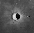
Lansberg (crater)
 Lunar Orbiter 4 image | |
| Coordinates | 0°18′S 26°36′W / 0.3°S 26.6°WCoordinates: 0°18′S 26°36′W / 0.3°S 26.6°W |
|---|---|
| Diameter | 39 km |
| Depth | 3.1 km |
| Colongitude | 26° at sunrise |
| Eponym | Philippe van Lansberge |


Lansberg is a lunar impact crater on the Mare Insularum. It can be located by following a line south-southwest from Copernicus to Reinhold, then southwest to Lansberg. The crater has a high rim and a central mountain. There are terraces along the inner walls, and the tops have slumped to produce a sharp edge. This formation is not noticeably eroded, and there are no significant impact craters within the interior.
The crater is correctly spelled "Lansberg", but has sometimes been written "Landsberg" instead. It is named for the Belgian/Dutch astronomer Philippe van Lansberge.[1]
Approximately 40 km to the southeast of Lansberg is the landing site of the Luna 5 probe, and a further 60 km in the same direction is the landing site of Surveyor 3 and Apollo 12.[2]

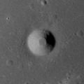
Satellite craters[]
By convention these features are identified on lunar maps by placing the letter on the side of the crater midpoint that is closest to Lansberg.
| Lansberg | Latitude | Longitude | Diameter |
|---|---|---|---|
| A | 0.2° N | 31.1° W | 9 km |
| B | 2.5° S | 28.1° W | 9 km |
| C | 1.5° S | 29.2° W | 17 km |
| D | 3.0° S | 30.6° W | 11 km |
| E | 1.8° S | 30.3° W | 6 km |
| F | 2.2° S | 30.7° W | 9 km |
| G | 0.6° S | 29.4° W | 10 km |
| L | 3.5° S | 26.4° W | 5 km |
| N | 1.9° S | 26.4° W | 4 km |
| P | 2.3° S | 23.0° W | 2 km |
| X | 1.2° N | 27.8° W | 3 km |
| Y | 0.7° N | 28.2° W | 4 km |
Lunar Orbiter 4 image of Lansberg A

Lunar Orbiter 4 image of Lansberg C (larger, bottom) and Lansberg G (top)

Oblique view of Lansberg B (lower right), Lansberg D (upper left), and Lansberg F (upper right) from Apollo 14

Closeup of Lansberg B from Apollo 14
Apollo 12 view of Lansberg P, 2 km diameter, and only 23 km northeast of Apollo 12 landing site


References[]
| Wikimedia Commons has media related to Lansberg (crater). |
- ^ "Lansberg (crater)". Gazetteer of Planetary Nomenclature. USGS Astrogeology Research Program.
- ^ Lunar and Planetary Institute, Digital Lunar Orbiter Photographic Atlas of the Moon, Photo Number IV-125-H3 (Annotated Lunar Orbiter 4 image)
- Andersson, L. E.; Whitaker, E. A. (1982). NASA Catalogue of Lunar Nomenclature. NASA RP-1097.
- Bussey, B.; Spudis, P. (2004). The Clementine Atlas of the Moon. New York: Cambridge University Press. ISBN 978-0-521-81528-4.
- Cocks, Elijah E.; Cocks, Josiah C. (1995). Who's Who on the Moon: A Biographical Dictionary of Lunar Nomenclature. Tudor Publishers. ISBN 978-0-936389-27-1.
- McDowell, Jonathan (July 15, 2007). "Lunar Nomenclature". Jonathan's Space Report. Retrieved 2007-10-24.
- Menzel, D. H.; Minnaert, M.; Levin, B.; Dollfus, A.; Bell, B. (1971). "Report on Lunar Nomenclature by the Working Group of Commission 17 of the IAU". Space Science Reviews. 12 (2): 136–186. Bibcode:1971SSRv...12..136M. doi:10.1007/BF00171763. S2CID 122125855.
- Moore, Patrick (2001). On the Moon. Sterling Publishing Co. ISBN 978-0-304-35469-6.
- Price, Fred W. (1988). The Moon Observer's Handbook. Cambridge University Press. ISBN 978-0-521-33500-3.
- Rükl, Antonín (1990). Atlas of the Moon. Kalmbach Books. ISBN 978-0-913135-17-4.
- Webb, Rev. T. W. (1962). Celestial Objects for Common Telescopes (6th revised ed.). Dover. ISBN 978-0-486-20917-3.
- Whitaker, Ewen A. (1999). Mapping and Naming the Moon. Cambridge University Press. ISBN 978-0-521-62248-6.
- Wlasuk, Peter T. (2000). Observing the Moon. Springer. ISBN 978-1-85233-193-1.
External links[]
- Oblique view of Lansberg at high sun angle from Apollo 12: AS12-51-7538
- LQ19 quadrangle
- Impact craters on the Moon