Latino Peak
This article needs additional citations for verification. (June 2013) |
 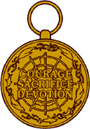 Antarctica Service Medal with "Wintered Over" device Reverse Side: A polar projection with the geodesic lines of the continent of Antarctica across which appear the words: COURAGE • SACRIFICE • DEVOTION | |
accompanying ribbon with wintered over clasp this medal is ranked higher than the Armed Forces Expeditionary Medal |


Latino Peak (72°9′S 167°33′E / 72.150°S 167.550°ECoordinates: 72°9′S 167°33′E / 72.150°S 167.550°E) is peak 2,290 metres (7,500 ft) high situated 4 nautical miles (7 km) south-southwest of Mount Hazlett in the Victory Mountains of Victoria Land, Antarctica.[1] It is the highest peak in the vicinity of the bifurcation where Tucker Glacier and Pearl Harbor Glacier converge. Its western slope is drained by Summers Glacier.
 WikiMiniAtlas
The peak was mapped by the United States Geological Survey from surveys and U.S. Navy aerial photos, 1960–64, and was named by the Advisory Committee on Antarctic Names for , a U.S. Navy SeaBee who camped at McMurdo Station on Ross Island as a member the U.S. Navy Antarctic Support summer expeditions of 1965, 1966.[1] He also wintered there as a member of the Operation Deep Freeze Winter-Over party of 1967 and also served in the Vietnam War in 1968–69.
References[]
- ^ a b "Latino Peak". Geographic Names Information System. United States Geological Survey. Retrieved 2013-06-04.
![]() This article incorporates public domain material from the United States Geological Survey document: "Latino Peak". (content from the Geographic Names Information System)
This article incorporates public domain material from the United States Geological Survey document: "Latino Peak". (content from the Geographic Names Information System)
This Borchgrevink Coast location article is a stub. You can help Wikipedia by . |
- Mountains of Victoria Land
- Borchgrevink Coast
- Borchgrevink Coast geography stubs