Le Margnès
Le Margnès | |
|---|---|
Part of Fontrieu | |
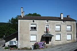 The town hall in Le Margnès | |
Location of Le Margnès  | |
 Le Margnès | |
| Coordinates: 43°38′31″N 2°36′07″E / 43.6419°N 2.6019°ECoordinates: 43°38′31″N 2°36′07″E / 43.6419°N 2.6019°E | |
| Country | France |
| Region | Occitanie |
| Department | Tarn |
| Arrondissement | Castres |
| Canton | Les Hautes Terres d'Oc |
| Commune | Fontrieu |
| Area 1 | 17.89 km2 (6.91 sq mi) |
| Population (2018)[1] | 50 |
| • Density | 2.8/km2 (7.2/sq mi) |
| Time zone | UTC+01:00 (CET) |
| • Summer (DST) | UTC+02:00 (CEST) |
| Postal code | 81260 |
| Elevation | 736–1,070 m (2,415–3,510 ft) (avg. 900 m or 3,000 ft) |
| 1 French Land Register data, which excludes lakes, ponds, glaciers > 1 km2 (0.386 sq mi or 247 acres) and river estuaries. | |


Le Margnès (French pronunciation: [lə maʁɲɛs]; Languedocien: Lo Marnhès) is a former commune in the Tarn department in southern France. On 1 January 2016, it was merged into the new commune of Fontrieu.[2]
See also[]
- Communes of the Tarn department
References[]
| Wikimedia Commons has media related to Le Margnès. |
This Tarn geographical article is a stub. You can help Wikipedia by . |
Categories:
- Former communes of Tarn (department)
- Populated places disestablished in 2016
- Tarn (department) geography stubs