Lemina
| Lemina | |
|---|---|
 Lemina after Talucco. | |
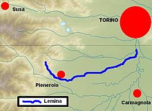 Location within the province of Turin | |
| Location | |
| Country | Italy |
| Physical characteristics | |
| Source | |
| • location | Monte Faiè |
| • elevation | about 1,300 m (4,300 ft) |
| Mouth | Chisola |
• coordinates | 44°57′44″N 7°39′19″E / 44.96222°N 7.65528°ECoordinates: 44°57′44″N 7°39′19″E / 44.96222°N 7.65528°E |
| Length | 46.1 km (28.6 mi)[1] |
| Basin size | 192.88 km2 (74.47 sq mi)[1] |
| Discharge | |
| • average | 3.2 m3/s (110 cu ft/s) |
| Basin features | |
| Progression | Chisola→ Po→ Adriatic Sea |

Lemina is a torrent in Piedmont, north-western Italy.
Geography[]

Metal plaque at the source of the Lemina
Lemina source is at 1,382 m above sea level at Monte Faiè, a peak of Monte Freidour in the central Cottian Alps, at the boundary between the communal territories of Pinerolo and San Pietro Val Lemina. It flows for some 46 km, until entering the Chisola near the communes of La Loggia and Vinovo, some kilometers east to Turin.
References[]
- ^ a b AA.VV. (2004-07-01). "Elaborato I.c/5". Piano di Tutela delle Acque - Revisione del 1º luglio 2004; Caratterizzazione bacini idrografici (PDF). Regione Piemonte. Archived from the original (pdf) on 2012-02-25. Retrieved 2017-01-26.
![]() Media related to Lemina at Wikimedia Commons
Media related to Lemina at Wikimedia Commons
Categories:
- Tributaries of the Po (river)
- Rivers of Italy
- Rivers of the Province of Turin
- Rivers of the Alps