Leninsky Avenue, Moscow
 | |||
| Native name | Ленинский проспект (Russian) | ||
|---|---|---|---|
| Length | 16 km (10 mi) | ||
| Location | Moscow | ||
| Nearest metro station |
| ||
| Coordinates | 55°41′04″N 37°32′23″E / 55.68444°N 37.53972°E | ||

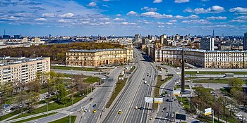
Leninsky Avenue (Russian: Ле́нинский проспе́кт) is a major avenue in Moscow, Russia, that runs in the south-western direction between in the central part of the city through to the Moscow Ring Road. It is a part of the M3 highway which continues from Moscow to Kaluga and Bryansk to the border with Ukraine, and provides connections with Kyiv and Odessa. It is also a part of the European route E101 connecting Moscow and Kyiv.
It is the second-widest street in Moscow after Leningradsky Avenue. Its width varies between 108 and 120 metres.[1]
Location[]
Leninsky Avenue continues north beyond as and southwest beyond the Ring Road as . Oktyabrskaya, Leninsky Prospekt, and Troparyovo are the only three metro stations located at the avenue, the second one being named after the avenue itself. Troparyovo is located at the southern end of the avenue, at the intersection with .
The major intersections are with the /Krymsky Val (Kaluzhskaya Square), and (Gagarin Square, where the avenue also crosses the Moscow Little Ring Railway and the Third Ring Road), , , /, as well as .
In terms of the administrative division, Leninsky Avenue runs through Yakimanka, Gagarinsky, Lomonosovsky, Obruchevsky, Prospekt Vernadskogo, Tyoply Stan, and Troparyovo-Nikulino Districts.
History[]
The location of the current avenue has been a road since before the 18th century. Only the area between Kaluzhskaya Square and Kaluzhskaya Zastava Square (currently Gagarin Square) was then included into Moscow, and the name of this stretch was Bolshaya Kaluzhskaya Street. Construction was active in that area between the 18th century and the 1940s. The road continued further as Kaluzhskoye Highway, and then as the highway from Moscow to Kyiv. The three stretches were merged in 1957, and the street was given the name of Vladimir Lenin. In the 1940s and the 1950s construction took place along the stretch between Gagarin Square and .[1]
Notable landmarks[]
In the vicinity of the avenue there are landmarks as such as Palace of Pioneers[2] and Lebedev Physical Institute.
Public transportation[]
The stretch between Kaluzhskaya Square and was covered by trolleybus traffic.[3] The whole avenue is covered by public bus traffic, though the routes typically take short stretches of the avenue, and there is no single route which travels through the whole length of the avenue.[4]
References[]
- ^ a b Ленинский просп. (in Russian). Intomoscow.ru. Retrieved 16 April 2014.
- ^ Shevchenko, Olga (17 December 2008). Crisis and the Everyday in Postsocialist Moscow. Indiana University Press. p. 54. ISBN 978-0-253-00257-0.
- ^ Маршруты Московского троллейбуса (in Russian). Ruzayn. Retrieved 15 April 2014.
- ^ Список маршрутов (in Russian). Ruzayn. Retrieved 15 April 2014.
- Streets in Moscow
- Roads in Moscow