Lepe, Hampshire
| Lepe | |
|---|---|
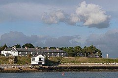 View towards the Coastguard cottages, Lepe | |
 Lepe Location within Hampshire | |
| OS grid reference | SZ450986 |
| Civil parish | |
| District |
|
| Shire county | |
| Region | |
| Country | England |
| Sovereign state | United Kingdom |
| Post town | SOUTHAMPTON |
| Postcode district | SO45 |
| Dialling code | 023[1] |
| Police | Hampshire |
| Fire | Hampshire and Isle of Wight |
| Ambulance | South Central |
| UK Parliament | |


Lepe is a linear hamlet on the Solent in south-west Hampshire, England. In the civil parish of Exbury and Lepe, It is beside the Dark Water, and has Lepe Country Park, which runs from Stanswood Bay to the mouth of the Beaulieu River.
Overview[]
Lepe is a hamlet on north-west shore of the Solent. It is part of the civil parish of Exbury and Lepe, which in turn is part of the New Forest district of Hampshire.[2] That parish (with minor powers) is emulated in the Church of England which maintains one church, as since early medieval times, at Exbury.[3] The east side is Lepe Country Park, with a mile of beach, pine-fringed cliffs, Operation Overlord remains (see below), year-round café-and-shop, and wild flower meadows;[4][5]
From the cliffs above the beach, part of the view of the Western Solent is used by Solent Rescue Independent Lifeboat station. Inchmery Quay lies to the west.
History[]
Lepe may have been a port of Roman times due to an apparent route of a Roman road, down the eastern side of the New Forest, from Shorn Hill, Totton to Lepe.[6]
Lepe is first recorded in the 13th century.[7] The name may refer to a human leap over the Dark Water.[7] For the centuries when manorial rights were the parent form of estate in most land, it was long part of Exbury manor, which in latter decades was frequently called the "manor of Exbury and Lepe."[8]
Oral history ascribes a populous seaside hamlet to Lepe washed away by a great storm before the early 1700s; a ruined harbour, Stone Point, is spoken of.[9] Old maps shows the Dark Water mouth was more easterly, near Stone Point.[10] An estate map of 1640 shows a tidal mill there, and the tidal pond is still identifiable.[11] The change may have been from the Great Storm of 1703 when the south coast of England was ravaged for five days.[10]
Lepe harbour survived, and in 1744 shipbuilder Moody Janverin was asked by the Admiralty to create a shipyard there.[12] Among ships built there were:
It had silted up by 1825.[13]
Around this time Lepe was involved in the oyster trade, large heaps being stacked here to purify.[8] A wooden quay was built at Lepe to serve the local brickyards until the coastal trade dropped given the advent of railways.[14] A Lepe coastguard station to combat west Solent smuggling.[12] Completed in 1828, the Coastguard Cottages and the Watch House remain largely unchanged today.[12]
In the 18th century, Lepe House was an inn, The Ship Inn.[12] It was later enlarged and beautified to become a grand country house.[8] In 1943, it was requisitioned by the Royal Navy, hosting the J.1 Assault Group for the D-Day landings to restore Normandy to free French rule in June 1944.[15]
Localised flooding has occurred in 2004, 2005 and in 2014.
Lepe and D-Day, 1944[]

Lepe was used as a secret manufacturing site. Six massive concrete caissons (type B2 Phoenix breakwaters) were built here then towed across the Channel where they formed part of the Mulberry harbours used after D-Day. Lepe was also one of the many places of embarkation of troops and equipment. Concrete mats shaped like big chocolate blocks reinforced the shingle beach for heavy vehicles. Some remain, as do pier remnants and concrete and brick structures.
Lepe beach was where PLUTO (Pipelines Under The Ocean) left the mainland: carrying fuel across to the Isle of Wight and under the English Channel to the Allied forces in Normandy and beyond.[16]
Notes[]
- ^ "Telecoms numbering". 23 March 2021.
- ^ "Election Maps". Ordnance Survey. Retrieved 2 February 2010.
- ^ https://www.achurchnearyou.com/search/?lat=50.785&lon=-1.361 Church of England – Ecclesiastical parish by coordinates
- ^ Visitor information Archived 2011-10-28 at the Wayback Machine, Lepe Country Park
- ^ Lepe Beach Café and Shop Archived 2011-10-22 at the Wayback Machine, Lepe Country Park
- ^ Arthur Clarke, (2003), The Roman road on the eastern fringe of the New Forest, from Shorn Hill to Lepe. Proceedings of Hampshire Field Club and Archaeological Society, 58, 33-58.
- ^ a b Lepe, Old Hampshire Gazetteer Archived 2012-04-04 at the Wayback Machine
- ^ a b c Victoria County History of Hampshire: Exbury
- ^ History of Lepe Archived 2011-11-07 at the Wayback Machine, Hantsweb
- ^ a b Lepe Beach and Stone Point, Hampshire, Geology of the Wessex Coast by Ian West
- ^ Hampshire County Council, (2005), Archaeology and Historic Buildings Record
- ^ a b c d e Lepe Estate - History
- ^ Timeline, Coastal Communities, Hantsweb
- ^ Hampshire Treasures Volume 5 (New Forest) Page 118 Archived 2012-06-09 at the Wayback Machine
- ^ Lepe House, Pastscape
- ^ Knight, Smith & Barnett 1998, p. 21.
References[]
- "D-Day at Lepe" - Pamphlet. Hampshire County Council.
- Knight, Bob; Smith, Harry; Barnett, Barry (1998). Pluto – World War II's Best-Kept Secret. Bexley Council's Local Studies Centre et al.
External links[]
| Wikimedia Commons has media related to Lepe, Hampshire. |

- Hamlets in Hampshire
- New Forest
- Operation Overlord
- Populated coastal places in Hampshire
- Beaches of Hampshire