Les Moëres, Nord
Les Moëres | |
|---|---|
Part of Ghyvelde | |
show Location of Les Moëres | |
 Les Moëres | |
| Coordinates: 51°01′01″N 2°33′00″E / 51.017°N 2.550°ECoordinates: 51°01′01″N 2°33′00″E / 51.017°N 2.550°E | |
| Country | France |
| Region | Hauts-de-France |
| Department | Nord |
| Arrondissement | Dunkerque |
| Canton | Dunkerque-2 |
| Commune | Ghyvelde |
| Area 1 | 19.46 km2 (7.51 sq mi) |
| Population (2017)[1] | 997 |
| • Density | 51/km2 (130/sq mi) |
| Demonym(s) | Morins |
| Time zone | UTC+01:00 (CET) |
| • Summer (DST) | UTC+02:00 (CEST) |
| Postal code | 59122 |
| Elevation | −4–2 m (−13.1–6.6 ft) (avg. 1 m or 3.3 ft) |
| 1 French Land Register data, which excludes lakes, ponds, glaciers > 1 km2 (0.386 sq mi or 247 acres) and river estuaries. | |


Les Moëres (West Flemish: De Moern) is a former commune in the Nord department in northern France. On 1 January 2016, it was merged into the commune Ghyvelde.[2]
Heraldry[]
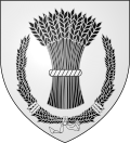 |
The arms of Les Moëres are blazoned : Argent, a garb of wheat sable tied argent, within a wreath of wheat sable, tied argent.
|
Population[]
| Year | Pop. | ±% |
|---|---|---|
| 2006 | 724 | — |
| 2007 | 732 | +1.1% |
| 2008 | 738 | +0.8% |
| 2009 | 753 | +2.0% |
| 2010 | 808 | +7.3% |
| 2011 | 862 | +6.7% |
| 2012 | 917 | +6.4% |
| 2013 | 945 | +3.1% |
See also[]
References[]
- ^ Téléchargement du fichier d'ensemble des populations légales en 2017, INSEE
- ^ Arrêté préfectoral 30 November 2015 (in French)
| Wikimedia Commons has media related to Les Moëres. |
| Authority control |
|
|---|
This Nord geographical article is a stub. You can help Wikipedia by . |
Categories:
- Former communes of Nord (French department)
- Nord (French department) geography stubs