Lewis and Clark Bridge (Columbia River)
Lewis and Clark Bridge | |
|---|---|
 | |
| Coordinates | 46°06′17″N 122°57′42″W / 46.1047°N 122.9618°W |
| Carries | |
| Crosses | Columbia River |
| Locale | Longview, Washington, to Rainier, Oregon |
| Maintained by | Washington State DOT |
| Characteristics | |
| Design | Cantilever through-truss |
| Total length | 2,722 feet (830 m)[1] |
| Longest span | 1,200 ft (366 m)[1] |
| History | |
| Designer | Joseph Strauss |
| Opened | March 29, 1930 |
Longview Bridge | |
 | |
| Location | Spans Columbia River, Longview, Washington |
| Coordinates | 46°6′16.8″N 122°57′42.6″W / 46.104667°N 122.961833°WCoordinates: 46°6′16.8″N 122°57′42.6″W / 46.104667°N 122.961833°W |
| Area | 7.2 acres (2.9 ha) |
| Built | 1929–30 |
| Built by | J.H. Pomeroy & Co. |
| Architect | Strauss Engineering Corp. |
| Architectural style | cantilever bridge |
| MPS | Historic Bridges/Tunnels in Washington State TR |
| NRHP reference No. | 82004208[2] |
| Added to NRHP | July 16, 1982 |
| Location | |
 | |

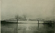
The Lewis and Clark Bridge is a cantilever bridge that spans the Columbia River between Longview, Washington, and Rainier, Oregon. At the time of completion, it had the longest cantilever span in the United States.[1]
The bridge was opened on March 29, 1930, as a privately owned bridge named the Longview Bridge. The $5.8 million cost (equivalent to $72 million in 2019 dollars) was recovered by tolls, $1.00 for cars and $.10 for pedestrians (equivalent to $12.37 for cars and $1.24 for pedestrians in 2019 dollars). At the time it was the longest and highest cantilever bridge in the United States. The state of Washington purchased the bridge in 1947 and the tolls were removed in 1965 after the bridge was paid for. In 1980, the bridge was rededicated as the Lewis and Clark Bridge in honor of the Lewis and Clark Expedition. The deck was replaced in 2003–04 at a cost of $29.2 million.
The bridge is 8,288 ft (2.5 km) long with 210 ft (64 m) of vertical clearance. The main span is 1,200 ft (366 m) long and the top of the bridge is 340 ft (104 m) above the river. It was designed by Joseph Strauss, the engineer of the Golden Gate Bridge.
In 1982, the bridge was entered on the National Register of Historic Places, as the Longview Bridge.[3] A feasibility study commissioned by the Washington State Legislature in 1990 recommended the construction of a second bridge to handle future traffic volumes.[4]
See also[]
- Lewis and Clark River Bridge
- List of bridges on the National Register of Historic Places in Oregon
- List of bridges in the United States by height
References[]
- ^ a b c d Jackson, Donald C. (1988). Great American Bridges and Dams. Wiley. p. 313. ISBN 0-471-14385-5.
- ^ "National Register Information System". National Register of Historic Places. National Park Service. July 9, 2010.
- ^ Washington - Cowlitz County at nationalregisterofhistoricplaces.com (non-government site). Retrieved June 8, 2013.
- ^ Lopez, Cindy (June 20, 1991). "State study: Second Longview-Rainier bridge needed". The Daily News. p. A1. Retrieved October 10, 2021 – via Newspapers.com.
External links[]
![]() Media related to Lewis and Clark Bridge at Wikimedia Commons
Media related to Lewis and Clark Bridge at Wikimedia Commons
- Bridge chronology – The Columbia County Historian
- Bridge story on HistoryLink.org
- Historic American Engineering Record (HAER) No. OR-127, "Lewis & Clark Bridge, Spanning Lewis & Clark River at Milepoint 4.78, on Warrenton Highway (Highway No. 9), Astoria, Clatsop County, OR", 16 photos, 6 data pages, 2 photo caption pages
- Lewis and Clark Bridge at Structurae
- Second Longview–Rainier Bridge Feasibility Study (1990) via WSDOT Library Digital Collections
Crossings of the Columbia River | ||||
|---|---|---|---|---|
| ||||
- Bridges over the Columbia River
- Longview, Washington
- Bridges completed in 1930
- Road bridges on the National Register of Historic Places in Washington (state)
- National Register of Historic Places in Columbia County, Oregon
- Transportation buildings and structures in Columbia County, Oregon
- Road bridges on the National Register of Historic Places in Oregon
- Transportation buildings and structures in Cowlitz County, Washington
- Road bridges in Washington (state)
- Road bridges in Oregon
- Bridges by Joseph Strauss (engineer)
- 1930 establishments in Oregon
- 1930 establishments in Washington (state)
- Historic American Engineering Record in Oregon
- Former toll bridges in Oregon
- Former toll bridges in Washington (state)
- Cantilever bridges in the United States
- Interstate vehicle bridges in the United States