Lichtenstein, Saxony
Lichtenstein | |
|---|---|
 The rear façade of the palace in Lichtenstein. | |
 Coat of arms | |
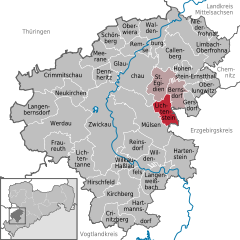
show Location of Lichtenstein within Zwickau district | |
 Lichtenstein | |
| Coordinates: 50°45′23″N 12°37′54″E / 50.75639°N 12.63167°ECoordinates: 50°45′23″N 12°37′54″E / 50.75639°N 12.63167°E | |
| Country | Germany |
| State | Saxony |
| District | Zwickau |
| Municipal assoc. | Rund um den Auersberg |
| Subdivisions | 3 |
| Government | |
| • Mayor (2015–22) | Thomas Nordheim[1] (FW) |
| Area | |
| • Total | 15.48 km2 (5.98 sq mi) |
| Elevation | 336 m (1,102 ft) |
| Population (2020-12-31)[2] | |
| • Total | 11,087 |
| • Density | 720/km2 (1,900/sq mi) |
| Time zone | UTC+01:00 (CET) |
| • Summer (DST) | UTC+02:00 (CEST) |
| Postal codes | 09350 |
| Dialling codes | 037204 |
| Vehicle registration | Z |
| Website | www.lichtenstein-sachsen.de |


Lichtenstein is a town in the Zwickau district, in Saxony, Germany. It is situated 11 km northeast of Zwickau, and 22 km southwest of Chemnitz. It was owned by the House of Schönburg from 1286 until 1945.
See also[]
 Media related to Lichtenstein/Sa. at Wikimedia Commons


The Old Castle at Lichtenstein
References[]
- ^ Bürgermeisterwahlen 2015, Freistaat Sachsen, accessed 13 July 2021.
- ^ "Bevölkerung des Freistaates Sachsen nach Gemeinden am 31. Dezember 2020". Statistisches Landesamt des Freistaates Sachsen (in German). June 2021.
| show Towns and municipalities in Zwickau (district) |
|---|
| show Authority control |
|---|
This Zwickau location article is a stub. You can help Wikipedia by . |
Categories:
- Towns in Saxony
- Zwickau (district)
- Kingdom of Saxony
- Bezirk Karl-Marx-Stadt
- Saxony geography stubs