Life zones of central Europe
Central Europe contains several life zones, depending on location and elevation.
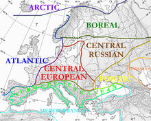
Geographically, Central Europe lies between the Baltic Sea and the Apennine and Balkan peninsulas. It includes the plains of Germany and Poland; the Alps; and the Carpathian Mountains. The Central European Flora region stretches from Central France to Central Romania and Southern Scandinavia.[1] The lowlands of Central Europe contain the Central European mixed forests ecoregion,[2] while the mountains host the Alps conifer and mixed forests[3] and Carpathian montane conifer forests ecoregions.[4]
An important factor in the local climate and ecology of Central Europe is the elevation: an increase of elevation by 1,000 metres (3,300 ft) causes the average air temperature to drop by 5 °C (9 °F) and decreases the amount of water that can be held by the atmosphere by 30%. This decrease in temperature and increase in rainfall result in altitudinal zonation, where the land can be divided into life zones of similar climate and ecology, depending on elevation.
Life zones[]
This section needs additional citations for verification. (October 2021) |
The life zones of the Eastern and Central Alps are:[5][6][7][8][9][10]
- Planar zone, under 300 m (East Alps), under 150 m (Central German hills), agriculture.
- Foothill zone, 300 – 800 m (East Alps), 150 – 300 m (Central German hills), oak limit (Quercus spp.). European Beech (Fagus sylvatica), Sessile oak (Quercus petraea), Pedunculate oak or English oak (Quercus robur), European or common hornbeam (Carpinus betulus) and small-leaved Lime (Tilia cordata). Grape crop limit (Vitis spp.), around 600 m, Switzerland, North Side, South Slope, estimated 7.5 °C. Crops: maize for feed; sweet maize (Zea mays).
- Submontane zone, 700 - 1,000 m (East Alps), 300 – 450 m (Central German hills), European Beech (Fagus sylvatica), Silver Fir or European Silver Fir (Abies alba) and Norway Spruce (Picea abies). Coniferous forests by reforestation limit around 800 m, North Side.
- Montane zone, 800 – 1,200 m (East Alps), 450 – 650 m (Central German hills), rye (Secale cereale) and wheat (Triticum spp.) crop limit.
- Mid-montane zone, 1,000 – 1,400 m (East Alps), 650 – 800 m (Central German hills). Limit of the whole year populated areas. Limit of a growing season of more than 100 days.
- Altimontane zone, 1,300 – 1,850 m (East Alps), 800 – 1,500 m (Central German hills). Deciduous forests limit, Sycamore Maple (Acer pseudoplatanus) and European Beech (Fagus sylvatica).
- Subalpine zone, 1,500 – 2,500 m (East Alps), above 1,500 m (Central German hills), Scots Pine (Pinus sylvestris), Norway Spruce (Picea abies), Swiss Pine (Pinus cembra, Arve or Zirbel) limit and European Larch (Larix decidua) limit, 2,000 m, some specimens up to 2,850 m, South Slope. Tree line and Krummholz zone or ecotone (stunted subalpine bushes), Sub-alpine meadow and Alpine climate.
- Alpine zone, 2,000 - 3,000 m (East Alps), Montane grasslands and shrublands. Mountain Pine or Mugo Pine (Pinus mugo) limit. Alpine meadows just used in the warm season.
- Snow zone, above 3,000 m (East Alps), alpine desert, scree, permafrost and above snow line.
Roughly one quarter of the land lying between the summits of the Alps is available for cultivation. Of this low country, about one half may be vineyards and grain fields, while the remainder produces forage and grass. Of the high country, about half is utterly barren, consisting of snow fields, glaciers, bare rock, lakes and stream beds. The other half is divided between forest and pasture, and the product of this half largely supports the relatively large population. For a quarter of the year the flocks and herds are fed on the upper pastures, but the true limit of the wealth of a district is the number of animals that can be supported during the long winter, and while one part of the population is engaged in tending the beasts and in making cheese and butter, the remainder is busy cutting hay and storing up winter food for the cattle.
Subalpine zone[]
The larger villages are mostly in the montane zone, but in many parts of the Alps the villages lie in the subalpine zone, at elevations varying from 1,200 to 1,800 m (3,900 to 5,900 ft). The most characteristic feature of this region is the prevalence of coniferous trees that, where they have not been removed, form vast forests that cover a large part of the surface. These play an important part in the natural economy of the country. They retain the soil by their roots, protect the valleys from destructive avalanches and heavy rains. In valleys where the forests have been cut away, waters pour down the slopes unchecked; floods devastates the floor of the valley, covering the soil with gravel and debris.
In the conifer forests of the Alps, the prevailing species are the Norway spruce and the silver fir; on siliceous soil the European larch flourishes. The Scots pine is chiefly found at a lower level and rarely forms forests. The Swiss pine is found scattered at intervals throughout the Alps but is not common. The mountain pine is common at higher altitudes, often forming a distinct zone of Krummholz above the level of its congeners on the higher mountains. In the Northern Alps the pine forests rarely surpass 1,800 m (5,900 ft) elevation, but on the south side they commonly attain 2,100 m (6,900 ft), while European larch, Swiss pine and mountain pine often extend above that elevation.
Alpine zone[]

The Alps are eponymous of the Alpine climate typical of the Alps between the tree line up to the permanent snow line, roughly between 1,800 and 2,500 m (5,900 and 8,200 ft). This alpine region contains the full beauty and variety of characteristic vegetation of the Alps.
The region contains many shrubs:
- Three species of rhododendron have masses of red or pink flowers.[11]
- The common junipers grow at elevations above the rhododendrons.
- Three species of bilberry are associated with the junipers.
- Several dwarf willows grow near the snow line.
Glacial zone[]
On the higher parts of lofty mountains in the Alps, more snow falls in each year than melts. A portion of this is carried away by the wind before it is consolidated, but a large portion accumulates in hollows and depressions of the surface and is gradually converted into glacier ice which descends by slowly flowing into the deeper valleys where it help swell perennial streams.
Mountain snow does not lie in beds of uniform thickness and some parts are more exposed to the sun and warm air than others. Beds of snow commonly alternate with exposed slopes covered with brilliant vegetation without an obvious boundary of perpetual snow. A seemingly clear boundary seems visible when a high mountain chain is viewed from a distance: Similar conditions are repeated at many different points, so that the level at which large snow beds show themselves can be seen as approximately horizontal. But this is true only as far as the conditions are similar. On the opposite sides of the same chain the exposure to the sun or to warm winds may cause a wide difference in the level of permanent snow, though the increased fall of snow on the side exposed to moist winds may more than compensate for the sun's rays.

Still, the "line of perpetual snow" is not fixed. The occurrence of favorable meteorological conditions during several successive seasons may and does increase the extent of the snowfields and lower the limit of seemingly permanent snow, while the opposite may cause the limit to rise higher on the flanks of the mountains. Attempts to fix accurately the level of perpetual snow in the Alps are difficult. Local accuracy might be established for a particular district. In some parts of the Alps, the limit is about 2,400 m (7,900 ft) elevation, while in others it cannot be placed much below 2,900 m (9,500 ft). As very little snow remains on rocks angled more than 60°, this is soon removed by the wind, some steep masses of rock remain bare even near the summits of the highest peaks, but as almost every spot offering the least hold for vegetation is covered with snow, few flowering plants are seen above 3,550 m (11,650 ft).
There is reason to think, however, that it is the lack of soil rather than climatic conditions that checks the upward extension of the alpine flora. Increased direct effect of solar radiation compensates for the cold of the nights, and in the few spots where plants have been found flowering up to a height of 3,650 m (11,980 ft), nothing has indicated that the processes of vegetation were arrested by the severe cold which they must sometimes endure. The climate of the glacial region has often been compared to that of the polar regions, but they are very different. Here, intense solar radiation by day, which raises the surface when dry to a temperature approaching 27 °C (81 °F), alternates with severe frost by night. In the Arctic, the Sun never sets and is only able to send feeble rays that maintain a low temperature, rarely rising more than a few degrees above the freezing point. Hence the upper region of the Alps sustains a far more varied and brilliant vegetation.
Climate[]
The effect of elevation on climate is evident when comparing climate normals as a function of elevation in Switzerland:
| Approx. coordinates of the weather station |
Precipitation | Altitude | Temperature | |
|---|---|---|---|---|
| Weissfluhjoch[12] | 46°50.0′N 9°48.4′E / 46.8333°N 9.8067°E | 1,411 mm | 2,691 m | -1.9 °C |
| Pilatus[13] | 46°58.7′N 8°15.1′E / 46.9783°N 8.2517°E | 1,752 mm | 2,106 m | 1.8 °C |
| Napf[14] | 47°00.3′N 7°56.4′E / 47.0050°N 7.9400°E | 1,708 mm | 1,404 m | 5.3 °C |
| Engelberg[15] | 46°49.3′N 8°24.6′E / 46.8217°N 8.4100°E | 1,559 mm | 1,036 m | 6.3 °C |
| Buchs-Suhr[16] | 47°23.1′N 8°04.8′E / 47.3850°N 8.0800°E | 1,076 mm | 387 m | 9.6 °C |
See also[]
- Climate of the Alps
- Life zones of the Mediterranean region
References[]
- ^ Frey, Wolfgang; Lösch, Rainer (2004). "Pflanze und Vegetation in Raum und Zeit". Lehrbuch der Geobotanik. München: Spektrum Akademischer Verlag.
- ^ "Central European mixed forests". Terrestrial Ecoregions. World Wildlife Fund.
- ^ "Alps conifer and mixed forests". Terrestrial Ecoregions. World Wildlife Fund.
- ^ "Carpathian montane conifer forests". Terrestrial Ecoregions. World Wildlife Fund.
- ^ Ellenberg, Heinz (1996). Vegetation Mitteleuropas mit den Alpen in ökologischer, dynamischer und historischer Sicht. Stuttgart: Ulmer. ISBN 3-8252-8104-3.
- ^ Mayer, Hannes (1974). Wälder des Ostalpenraumes. Standort, Aufbau und waldbaulichen Bedeutung der wichtigsten Waldgesellschaften in den Ostalpen samt Vorland. Ökologie der Wälder und Landschaften vol. 3. Stuttgart, New York: Gustav Fischer Verlag. p. 344. ISBN 3-437-30166-7.
- ^ Mayer, Hannes (1984). Wälder Europas. Stuttgart, New York: Gustav Fischer Verlag. p. 691. ISBN 3-437-30441-0. Retrieved 2010-05-06.
- ^ Wittmann, O. (1983). Standortkundliche Landschaftsgliederung von Bayern. Materialien. Vol. 21. München: Bayerisches Staatsministerium für Landesentwicklung und Umweltfragen.
- ^ Kilian, W.; F. Müller; F. Starlinger (1993). Die forstlichen Wuchsgebiete Österreichs. Eine Naturraumgliederung nach waldökologischen Gesichtspunkten. Wien: Forstliche Bundesversuchsanstalt. p. 53. ISSN 0374-9037. (Webdokument, pdf; online: "Die forstlichen Wuchsgebiete Österreichs". Institut für Waldökologie und Boden, BfW. 2005-03-15. Archived from the original on 2008-04-11. Retrieved 2008-03-12.)
- ^ Härdtle, W.; Ewald, J.; Hölzel, N. (2004). Wälder des Tieflandes und der Mittelgebirge. Ökosysteme Mitteleuropas in geobotanischer Sicht. Stuttgart: Ulmer. p. 257.
- ^ Jenny, Jakob. "The Native Rhododendrons of Switzerland". J. American Rhododendron Society.
- ^ "Climate Norm Value Tables" (PDF). Climate diagrams and normals from Swiss measuring stations. Federal Office of Meteorology and Climatology (MeteoSwiss). Retrieved 15 October 2021.
- ^ "Climate Normals Pilatus, Reference Period 1981–2010" (PDF). Zurich Airport, Switzerland: Federal Office of Meteorology and Climatology – MeteoSwiss. Retrieved 2016-11-14.
- ^ "Climate Norm Value Tables" (PDF). Climate diagrams and normals from Swiss measuring stations. Federal Office of Meteorology and Climatology (MeteoSwiss). Retrieved 13 October 2021.
- ^ "Climate normals Engelberg" (PDF). Zurich Airport, Kloten, Switzerland: Federal Office of Meteorology and Climatology - MeteoSwiss. 26 April 2016. Retrieved 2019-07-07.
- ^ "Climate Norm Value Tables" (PDF). Climate diagrams and normals from Swiss measuring stations. Federal Office of Meteorology and Climatology (MeteoSwiss). Retrieved 15 October 2021.
- Climate of the Alps
- Ecology of the Alps
- Palearctic realm
- Ecoregions of Europe
- Montane ecology
- Geography of Central Europe