Lilienstein
show This article may be expanded with text translated from the corresponding article in German. (July 2010) Click [show] for important translation instructions. |
| Lilienstein | |
|---|---|
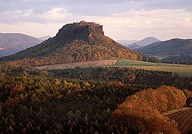 Lilienstein at sunset | |
| Highest point | |
| Elevation | 415.2 m (1,362 ft) |
| Coordinates | 50°55′52″N 14°05′05″E / 50.931111°N 14.084722°ECoordinates: 50°55′52″N 14°05′05″E / 50.931111°N 14.084722°E |
| Geography | |
| Geology | |
| Mountain type | Table |
| Type of rock | Sandstone |


Lilienstein is a highly distinctive mountain in Saxon Switzerland, in Saxony, southeastern Germany, and was once the site of a Bohemian castle. It is one of the few table mountains on the east of the river Elbe and constitutes the symbol of the Saxon Switzerland National Park.
Name[]
The name is not related to the flower lily (German: Lilie) but is probably derived from St. Gilgen or St. Ilgen (earlier names of the mountain were „Ylgenstein“ und „Illgenstein“). These names refer to Saint Giles.
Location[]
The Lilienstein is located 15 km east of Pirna and 5 km west of Bad Schandau. It overlooks the river Elbe, which forms an 180° loop around the mountain. The Königstein Fortress is located opposite on the left bank of the river.
| Authority control |
|---|
This Saxony location article is a stub. You can help Wikipedia by . |
This Sächsische Schweiz-Osterzgebirge location article is a stub. You can help Wikipedia by . |
- Mountains of Saxon Switzerland
- Elbe Sandstone Mountains
- Königstein, Saxony
- Rock formations of Saxon Switzerland
- Saxony geography stubs
- Sächsische Schweiz-Osterzgebirge district geography stubs