List of New York State Historic Markers in Chenango County, New York
This article may require cleanup to meet Wikipedia's quality standards. The specific problem is: <List needs more information, please fill out. Also, names should not be all caps>. (November 2015) |
Afton, New York "This is an incomplete list of New York State Historic Markers in Chenango County, New York.[1] Afton, New York
Listings county-wide[]
| City or Town | Marker name[1] | Image | Date designated | Location | City or Town | Coords | Marker text | |
|---|---|---|---|---|---|---|---|---|
| Afton, Town of, New York | HISTORIC NEW YORK |  Historic marker of Historic New York, Unadilla Region, Afton, NY. |
Education Department State of New York 1965 Department of Public Works | NYS Route 7 between Bainbridge and Afton, NY at traffic pull off | Afton, Town of, New York | N 42˚14’32.2”
W 75˚29’37.8” |
HISTORIC NEW YORK
UNADILLA REGION Indians living in the valleys of the Unadilla and Susquehanna Rivers played an important role in the region’s early history. | |
| Afton, Town of, New York | MORMON HOUSE | 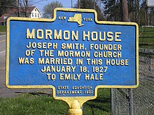 Historic marker of Mormon House, Afton, NY |
State Education Department 1932 | 20 feet east of NYS Route 41 in front of Afton Fair Grounds, Afton, NY | Afton, Town of, New York | N 42˚13'17.9"
W 75˚31'18.3" |
MORMON HOUSE
Joseph Smith, founder of the Mormon Church was married in this house to Emily Hale | |
| Bainbridge, Town of, New York | FIRST TOLL GATE | 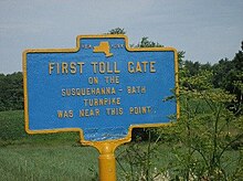 Historic marker of the first toll gate on the Susquehanna-Bath Turnpike was near this point in Bainbridge, NY. |
State Education Department | West Main Street, NYS Route 206. 3 miles northwest of Bainbridge, NY | Bainbridge, Town of, New York | N 42˚18'30.1"
W 75˚31'18.0" |
FIRST TOLL GATE
On the Susquehanna-Bath Turnpike was near this point | |
| Columbus, Town of, New York | ARROW (CARR FARM) |  Historic marker of the Carr farm, Brant's Indians and Tories meeting place, 1770-1778 in Columbus, NY. |
Erected 2002 | NYS Route 8 about six miles north of New Berlin, NY. In the town of Columbus, NY | Columbus, Town of, New York | N 42˚39'43.0”
W 75˚19'55.8” |
1/4 MILE
To Historic Carr Farm Meeting Place Of Brant's Indians And Tories 1770–1778 | |
| Lincklaen, Town Of, New York | JOHN B. FINCH | 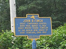 Historic marker of John B. Finch, Lincklaen, NY, Right Worthy Grand Templar of the World Wide Order of Good Templars. |
State Education Department 1938 | Chenango Co. Route 12.1½ miles north of Lincklaen, NY | Lincklaen, Town Of, New York | N 42˚41'44.7"
W 75˚52'24.1” |
JOHN B. FINCH
Great Temperance Orator, Born Here March 17, 1852 Right Worthy Grand Templar Of The World-wide Order Of Good Templars, 1884-1887 | |
| McDonough, Town Of, New York | DEACON TOWNE | 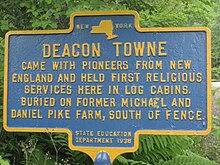 Historic marker of Deacon Towne, he held the first religious services in McDonough, NY. Buried on former Michael and Daniel Pike Farm. |
State Education Department 1938 | NYS Route 220 at village of McDonough, NY, north on Pike Road then right on Beckwith Road | McDonough, Town Of, New York | N 42˚31'16.7”
W 75˚44'44.6” |
DEACON TOWNE
Came With Pioneers From New England And Held First Religious Services Here In Log Cabins Buried On Former Michael And Daniel Pike Farm, South Of Fence. | |
| Columbus, Town of, New York | UNADILLA RIVER |  Historic marker of the Unadilla River, lands to the west ceded to New York State by the Iroquois via treaty of September 22, 1788. |
Erected 2002 | NYS Route 8, north of New Berlin, NY in the town of Columbus, NY on east side of road in row of trees overlooking the river | Columbus, Town of, New York | N 42˚39’43.0” W 75˚19’55.8” | UNADILLA RIVER
Lands west of river ceded to NY State by Iroquois in a Treaty made by Gov.George Clinton at Fort Schuyler, September 22, 1778 | |
| Greene, Town Of, New York | CHENANGO CANAL #16 |  Historic marker of Chenango Canal #16 Historic building was inn of canal travelers 1846-56. Canal boat repair station was east of road. |
Chenango Co. Bicentennial ‘82 | NYS Route 12 at Brisben, NY | Greene, Town Of, New York | N 42°21’54.7”
W 75°40’50.9” |
CHENANGO CANAL 1837-1878
Historic building was inn of canal travelers 1846-56. Canal boat repair station was east of road. | |
| Greene, Town Of, New York | CHENANGO CANAL #17 |  Historic marker of Chenango Canal tow path and bed. |
Chenango Co. Bicentennial ‘82 | NYS Route 12, 2.1 miles south of Oxford, NY | Greene, Town Of, New York | N 42˚21’08.7”
W 75˚43’30.2” |
CHENANGO CANAL 1837-1878
The canal bed and towpath curve around to make level route on the valley floor. | |
| Greene, Town Of, New York | CHENANGO CANAL #19 | 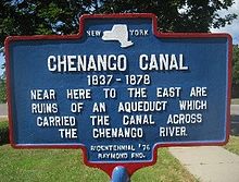 Historic marker, Chenango Canal #19. Ruins of Aqueduct over the Chenango River, Greene, NY |
Chenango Co. Bicentennial ‘82 | NYS Route 12, just south of Greene, NY | Greene, Town Of, New York | N 42˚19’24.6”
W 75˚46’34.5” |
CHENANGO CANAL 1837-1878
Near here to the east are ruins of an aqueduct which carried the canal across the Chenango River | |
| Greene, Town Of, New York | CHENANGO CANAL #20 | 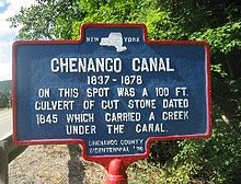 Historic maker, Chenango Canal # 20. 1845 culvert, Greene, NY. |
Chenango Co. Bicentennial ‘82 | NYS Rt. 12, south of the Village of Greene, NY | Greene, Town Of, New York | N 42˚18’31.1
W 75˚46’42.7” |
CHENANGO CANAL 1837-1878
On this spot was a 100 ft. culvert of cut stone dated 1845 which carried a creek under the canal. | |
| North Norwich, Town of, New York | CHENANGO CANAL #5 | 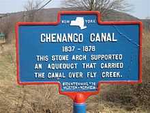 Historic marker of Chenango Canal #5: Aqueduct at North Norwich, NY |
Chenango Co. Bicentennial ‘82 | NYS Route. 12, just south of the village of North Norwich, NY | North Norwich, Town of, New York | N 42°36’35.0”
W 75°31’39.3” |
CHENANGO CANAL 1837-1878
This stone arch supported an aqueduct that carried the canal over Fly Creek. | |
| North Norwich, Town of, New York | CHENANGO CANAL #6 | 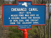 Historic marker of Chenango Canal #6: Meads Pond holding basin at North Norwich, NY |
Chenango Co. Bicentennial ‘82 | NYS Route 12, south of the village of North Norwich, NY at Meads Pond | North Norwich, Town of, New York | N 42°34'18.9"
W 75°31'41.4" |
CHENANGO CANAL 1837-1878
Meads Pond was used as a holding basin for barges of iron, coal and freight from the adjacent canal. | |
| North Norwich, Town of, New York | CHENANGO CANAL #7 | 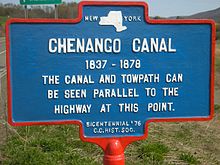 Historic marker of Chenango Canal #7: canal and towpath at North Norwich, NY |
Chenango Co. Bicentennial ‘82 | NYS Route 12 south of the village of North Norwich, NY by the Warren Eaton Airport runway | North Norwich, Town of, New York | N 42°33'58.4"
W 75°31'45.9" |
CHENANGO CANAL 1837-1878
The canal and towpath can be seen parallel to the highway at this point. | |
| Norwich, City of, New York | CHENANGO CANAL #10 | Chenango Co. Bicentennial ‘82 | On NYS Route 12, South Broad Street, Norwich, NY | Norwich, City of, New York | N 42°31’1.7”
W 75°31’22.6” |
CHENANGO CANAL 1837-1878
Just west a large wooden aqueduct spanned the creek.$2,500,000 canal linked area to Utica, Binghamton. | ||
| Norwich, City of, New York | CHENANGO CANAL #11 | Chenango Co. Bicentennial ‘82 | NYS Route 12 | Norwich, Town of, New York | CHENANGO CANAL 1837-1878
Here canal is visible south of old Lock House where packets stopped for passengers. | |||
| Norwich, City of, New York | CHENANGO CANAL #12 | Chenango Co. Bicentennial ‘82 | NYS Route 12 | Norwich, Town of, New York | CHENANGO CANAL 1837-1878
East of road are remains of a lock and feeder pond where canal passed through productive farm country. | |||
| Norwich, City of, New York | CHENANGO CANAL #9 |  Historic marker of Chenango Canal #9. Bridge, site of where 1,000 men of the 114th NY Regt. left for the Civil War by flotilla, Sept 6, 1862, Norwich, NY. |
Chenango Co. Bicentennial ‘82 | NYS Route 12 | Norwich, City of, New York | N 42°31'42.4
W 75°31'25.4" |
CHENANGO CANAL 1837-1878
Canal bridge site where 1000 men of 114th Regt. embarked by flotilla to Civil War, | |
| Oxford, Town of, New York | CHENANGO CANAL #15 |  Historic marker of Chenango Canal #15, Bowman Creek, north of Lock 99, Oxford, NY. |
Chenango Co. Bicentennial ‘82 | NYS Route 12 | Oxford, Town of, New York | N 42°24’13.6”
W 75°38’07.9” |
CHENANGO CANAL 1837-1878
Remains of the Aqueduct which carried the Canal across Bowman Creek, north of Lock 99 | |
| Oxford, Town of, New York | CHENANGO CANAL #13 |  Historic marker of Chenango Canal #13: original stone arch carrying canal over creek at Oxford, NY |
Chenango Co. Bicentennial ‘82 | NYS Route 12 | Oxford, Town of, New York | N 42°22’38.0”
W 75°39’15.7” |
CHENANGO CANAL 1837-1878
Original stone arch carrying canal over creek about 150 yds. due east. | |
| Oxford, Town of, New York | CHENANGO CANAL #14 |  Historic marker of the Chenango Canal #14, turning basin, Oxford, NY. |
Chenango Co. Bicentennial ‘82 | NYS Route.12 | Oxford, Town of, New York | N 42°26’38.0”
W 75°35’45.8” |
CHENANGO CANAL 1837-1878
1837-1878 The Oxford turning basin site of overnight tie up for canal boats. | |
| Oxford, Town of, New York | CHENANGO CANAL #15 |  Historic marker Chenango Canal #15 2 canal bed and towpath, Oxford, NY |
Chenango Co. Bicentennial ‘82 | NYS Route 12, Oxford, NY, to Chenango County Rd 3 | Oxford, Town of, New York | N 42°25’26.9”
W 75°38’00.2” |
CHENANGO CANAL 1837-1878
Canal bed and towpath wound its way through the valley following the foot of the hills. | |
| Sherburne, Town of, New York | CHENANGO CANAL #2 |  Historic marker of the Chenango Canal #2, Sherburne, NY |
Chenango Co. Bicentennial ‘82 | NYS Route 12, north of Sherburne, NY | Sherburne, Town of, New York | N 42°41’52.5”
W 75°30’49.1” |
CHENANGO CANAL 1837-1878
Just west can be seen the canal bed, towpath and site of woolen mill and other canal related industries | |
| Sherburne, Town of, New York | CHENANGO CANAL #3 | 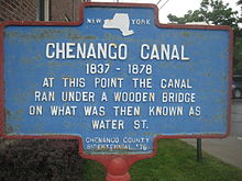 Historic marker of Chenango Canal # 3, canal under wooden bridge, Water Street, Sherburne, NY. |
Chenango Co. Bicentennial ‘82 | NYS Route 80, West State Street, Sherburne, NY | Sherburne, Town of, New York | N 42°40’41.9”
W 75°30’00.4” |
CHENANGO CANAL 1837-1878
At this point the canal ran under a wooden bridge on what was then known as Water St. | |
| Sherburne, Town of, New York | CHENANGO CANAL #4 |  Historic marker of Chenango Canal #4, barn for mules, Sherburne, NY. |
Chenango Co. Bicentennial ‘82 | NYS Route 12, South Main Street, Sherburne, NY | Sherburne, Town of, New York | N 42°40’30.2”
W 75°29’51.5” |
CHENANGO CANAL 1837-1878
In barn at the rear of this house, mules were kept to tow boats on the adjoining canal. | |
| Greene, Town of, New York | FIRST CHURCH IN VILLAGE OF GREENE |  Historic marker of the Congregational Church of Greene, NY. |
Chenango County Bicentennial '76 | North Chenango Street, Greene, NY, in front of First Congregational Church | Greene, Town of, New York | N 42˚19’55.0”
W 75˚46’04.1” |
FIRST CHURCH IN VILLAGE OF GREENE
This Congregational Church was organized in 1811. The first pastor was Rev. John B. Hoyt. | |
| Greene, Town of, New York | FIRST BAPTIST CHURCH |  Historic marker of first Baptist Church in Greene, NY |
State Education Department 1936 | South Chenango Street, Greene, NY | Greene, Town of, New York | N 42˚19’39.3”
W 75˚46’18.8” |
FIRST BAPTIST CHURCH
In Chenango County organized on this site by Elder Nathaniel Kellogg in 1795 | |
| Greene, Town of, New York | FIRST BRIDGE |  Historic marker of the first bridge over the Chenango River built 1807in Greene, NY. The Susquehanna and Bath Turnpike crossed here. |
State Education Department 1936 | Washington Street, Greene, NY, east side of the Chenango River | Greene, Town of, New York | N 42˚19’41.1”
W 75˚46’03.6” |
FIRST BRIDGE
Across the Chenango river was built on this site in 1807. Susquehanna and Bath Turnpike crossed here | |
| Greene, Town of, New York | FIRST REFRIGERATOR PLANT |  Historic marker of first Refrigeration Plant in the United States, 1875-1900, Greene, NY |
Greene Bicentennial Committee | North Genegantslet Road, north of intersection of Clark Road, Greene, NY | Greene, Town of, New York | N 42˚21’18.9”
W 75˚48’37.0” |
FIRST REFRIGERATOR PLANT
East of this spot believed to be the First Refrigeration Plant in United States 1875-1900 | |
| Greene, Town of, New York | GO-WON-GO MOHAWK |  Historic marker of Go-Won-Go Mohawk, home. Indian Princess from Greene, NY |
State Education Department 1936 | South Chenango and Page Street, Greene, NY | Greene, Town of, New York | N 42˚19’45.0”
W 75˚46’12.0” |
GO-WON-GO MOHAWK
An Indian princess lived in this house. | |
| Greene, Town of, New York | EARLY SETTLERS |  Historic maker of the early settlers of Greene, NY. |
North Chenango Street by Birdsall Brook, Greene, NY | Greene, Town of, New York | N 42˚19’59.5”
W 75˚46’00.6” |
EARLY SETTLERS
Included Joseph Juliand, Simon Barnett, and Stephen Ketchum. In 1795 Talleyrand visited early French settlement here. | ||
| Greene, Town of, New York | GREENE |  Historic marker of the village of Greene, NY. Laid out in 1806 by Elisha Smith. First called Hornby, renamed for General Nathaniel Greene. |
State Education Department 1936 | Park at Cutler Road, North Washington Street, and North Chenango Street, Greene, NY | Greene, Town of, New York | N 42˚20’12.3”
W 75˚45’57.1” |
GREENE
Village laid out in 1806 by Elisha Smith. Was first called Hornby, later named for Gen. Nathaniel Greene. Incorporated 1842. | |
| Greene, Town of, New York | FIRST HOTEL |  Historic marker of the first hotel in Greene, NY built 1803 by Thomas Wattles. |
South Chenango Street at intersection of Genesee Street, Greene, NY | Greene, Town of, New York | N 42˚19’45.1”
W 75˚46’12.4” |
FIRST HOTEL
In Greene Erected On This Site In 1803 By Thomas Wattles | ||
| Greene, Town of, New York | STEPHEN KETCHUM |  Historic marker of Stephen Ketchum's log cabin, built, 1792 in Greene, NY. |
Corner of South Chenango Street, Greene, NY | Greene, Town of, New York | N 42˚19’45.0”
W 75˚46’12.0” |
STEPHEN KETCHUM
Settled near this site in the Town of and built his log cabin in 1792 | ||
| Greene, Town of, New York | WILCOX HOMESTEAD | 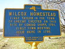 Historic marker of Wilcox Homestead, Greene, NY |
State Education Department 1938 | NYS Route 12 north of Greene, NY, between Elmer Smith Road and Chenango County. Route 3A | Greene, Town of, New York | N 42°20’59.2”
W 75°44’06.7” |
WILCOX HOMESTEAD
First tavern in the Town of erected on this site by Conrad Sharp, 1794. First Town Meeting Held Here in 1798 | |
| Guilford, Town of, New York | FIRST DOCTOR |  Historic marker of Dr. John Clark the first doctor in Guilford, NY. |
Guilford Bicentennial Historical Committee 1995 | Main Street, Guilford, NY | Guilford, Town of, New York | N 42°24’17.6”
W 75°29’25.3” |
FIRST DOCTOR
Site of First Office and Residence Dr. John Clark | |
| Guilford, Town of, New York | FIRST LOG CABIN | 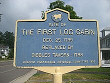 Historic marker of the first log cabin, Guilford, NY. |
Guilford Bicentennial Historical Committee 1995 | Main Street, Guilford, NY | Guilford, Town of, New York | N 42°24’22.9”
W 75°29’32.0” |
FIRST LOG CABIN
Site of The First Log Cabin Dec. 25, 1795 Replaced by Dibbles Tavern - 1798 | |
| McDonough, Town of, New York | EARLY INDUSTRY | 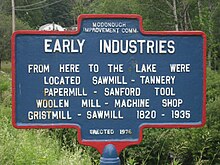 Historic marker of early industry of 1820-1935 in McDonough, NY |
Erected 1976 | NYS Route 220 by Creek Road, Pharsalia, NY | McDonough, Town of, New York | N 42°29’52.7”
W 75°45’26.5” |
EARLY INDUSTRY
From here to the lake were located Sawmill – Tannery - Papermill – Sanford Tool Woolen Mill – Machine Shop - Grist Mill - Sawmill 1820-1935 | |
| McDonough, Town of, New York | KELLY GRANGE | McDonough, Town of, New York | N 42˚29’34.3”
W 75˚44’33.3” |
KELLY GRANGE | ||||
| McDonough, Town of, New York | MCDONOUGH | 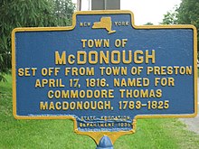 Historic marker of the Town of McDonough, NY. |
McDonough, Town of, New York | N 42°29’55.2”
W 75°46’03.6” |
TOWN OF MCDONOUGH
Set off from Town of Preston April 17, 1816. Named for Commodore Thomas MacDonough, 1783-1825 | |||
| New Berlin, Town of, New York | JOHN P. USHER |  Historic marker of John P. Usher, New Berlin, NY. Secretary of the Interior under President Lincoln. |
Erected 2002 | NYS Route 8 north of Village of New Berlin, NY, north end of park | New Berlin, Town of, New York | N 42°7’38.6”
W 75°19’56.1” |
JOHN P. USHER
Secretary of Interior under Abraham Lincoln Practiced law in New Berlin with John Hyde 1837-1839 | |
| New Berlin, Town of, New York | HISTORIC LAW OFFICE |  Historic marker of Law Office, 1830-1995, New Berlin, NY |
NYS Route 8, center of Village of New Berlin, NY | New Berlin, Town of, New York | N 42°7’24.7”
W 75°19’56.2” |
HISTORIC LAW OFFICE
Erected in the early 19th century and continuously occupied by local attorneys from CA. 1830-1995. Attorneys included: General A.C. Welch H.H. Harrington, A.C. Morse, and James Honeywell | ||
| New Berlin, Town of, New York | NEW BERLIN |  Historic marker of Anson Burlingame, New Berlin, NY |
State Ed. Dept. 1935 | NYS Route 8 south of Village of New Berlin, NY | New Berlin, Town of, New York | N 42°37’05.3”
W 75°19’58.7” |
NEW BERLIN
First settled about 1790 Anson Burlingame born here U.S. Minister to under President Lincoln | |
| New Berlin, Town of, New York | NYO&W Depot | 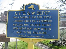 Historic marker of N.Y. O & W Depot, New Berlin, NY. |
Unadilla Valley Railway Soc. | Genesee Street (east) and Railroad Street, New Berlin, NY | New Berlin, Town of, New York | N 42°37’28.9”
W 75°19’43.3” |
N.Y.O.&.W. Depot
1869 Board & Batten Depot- Largest Built by N.Y. Oswego Midland and R.R. its size shows how important New Berlin was to the railroad. | |
| New Berlin, Town of, New York | SITE OF DANIEL SCRIBNER'S HOME | 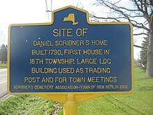 Historic marker of Daniel Scribner's home, built 1790, first in township, New Berlin, NY. |
Scribner's Cemetery Association-Town of New Berlin 2002 | NYS Route 8, 2 mile south of Village of New Berlin, NY | New Berlin, Town of, New York | N 42°35’29.5”
W 75°20’12.7” |
SITE OF DANIEL SCRIBNER'S HOME
Built 1790, First house in 16th Township. Large log building used as trading post and for town meetings | |
| New Berlin, Town of, New York | ST ANDREWS CHURCH AND CEMETERY |  Historic marker of St. Andrews Church and cemetery, New Berlin, NY. |
St. Andrews Church and Cemetery 2002 | NYS Route 8 in Village of New Berlin, NY, south of St. Andrews Church | New Berlin, Town of, New York | N42°37’18.0”
W 75°19’55.5” |
ST ANDREWS CHURCH AND CEMETERY
Worship began in 1808 led by Fr. Daniel Nash. First Episcopal Church in Chenango. Cemetery owned by church. | |
| North Norwich, Town of, New York | OBADIAH GERMAN |  Historic marker of 1798 North Norwich home of Obadiah German, first US Senator Chenango County, NY. |
Sesquicentennial 1849-1999 | Chenango County Road 23 & 23A in front of Town Hall, former schoolhouse in village of North Norwich, NY | North Norwich, Town of, New York | N 42°37'5.3"
W 75°31'38.5" |
OBADIAH GERMAN
On this site, 1798, stood the home of Obadiah German; Militia General - Land Agent - State Assemblyman - United States Senator 1809-1815 | |
| Norwich, Town of, New York | AVERY POWER |  Historic marker of Avery Power, Norwich, NY |
State Education Department 1936 | NYS Route 12, 1 mile south of City of Norwich, NY | Norwich, Town of, New York | N 42°30'37.2"
W 75°31'21.1" |
AVERY POWER
First settler in Norwich 1788, owned adjoining river flat. Lucy Power, first white native (born) of Chenango valley. | |
| Norwich, Town of, New York | CANASAWACTA CREEK |  Historic marker of Canasawacta Creek, Norwich, NY |
N.Y. State Highway | NYS Route 12, between the Canasawacta Creek and the entrance to Mt. Hope Cemetery, south of the City of Norwich, NY | Norwich, Town of, New York | N 42 31’09.4”
W 75 31’22.4” |
CANASAWACTA CREEK | |
| Norwich, City of, New York | 1789 | 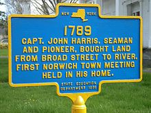 Historic marker of Captain John Harris, Norwich, NY |
State Education Department 1936 | NYS Route 12, north of NYS Route 23 intersection in Norwich, NY | Norwich, City of, New York | N 42°32’17.3”
W 75°31’27.4” |
1789
Capt. John Harris, seaman and pioneer, bought land from Broad Street to river. First town meeting held in his home. | |
| Norwich, City of, New York | FIRST LOG CABIN |  Historic marker of log cabin built by Colonel William Monroe. |
State Education Department 1936 | NYS Route 12, City of Norwich, NY, West Park in front of Chenango County Courthouse | Norwich, City of, New York | N 42 31’54.2” W 75 31’28.7” | FIRST LOG CABIN
In Norwich was built on this site about 1790 by Colonel William Monroe “Drummer Boy of the Revolutionary War.” | |
| Norwich, City of, New York | O&W RAILROAD YARDS |  Historic marker of the O & W Railroad yards of Norwich, NY |
Midland Drive, in front of Norwich High School, City of Norwich, NY | Norwich, City of, New York | N 42°31’40.1”
W 75°30’52.5” |
RAILROAD YARDS
On This Site Were Located Northern Division Offices, Yards, Repair Shops, of the New York, Ontario & Western Railway 1868-1957 | ||
| Norwich, Town of, New York | RUTH BENEDICT |  Historic marker of the childhood home of Dr. Ruth Benedict. A well known anthropologist and author of Patterns of Culture. |
NYS Route 12 south of the City of Norwich, NY and Unisom/GE Plant. Red house with white trim | Norwich, Town of, New York | N 42°29’36.5”
W 75°31’56.5” |
RUTH BENEDICT
1887-1948 Childhood Home of Dr. Ruth Benedict. First Well – Known Woman Anthropologist. Author, Patterns of Culture | ||
| Norwich, Town of, New York | THE CASTLE | 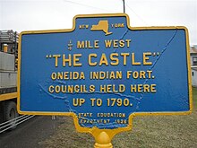 Historic marker of "The Castle" of Norwich, NY |
State Education Department 1936 | East River Road, south of Polkville, NY, 1/2 mile on west side of road | Norwich, Town of, New York | N 42°30’41.8”
W 75°30’32.1” |
¼ Mile West “THE CASTLE”
Oneida Indian Fort Councils held here up to 1790 | |
| Norwich, Town of, New York | WARNING CURVE |  Historic marker of the Warning curve, Norwich, NY. |
New York State Highway | NYS Route 12 south of the City of Norwich, NY, past the cemetery | Norwich, Town of, New York | N 42°30’30.0”
W 75°31’21.2” |
WARNING CURVE | |
| Norwich, Town of, New York | WHITE STORE CHURCH |  Historic marker of the White Store Church, Norwich, NY |
State Education Department 1935 | NYS Route 8 at White Store Cemetery, Norwich, NY | Norwich, Town of, New York | N 42°29'1.6"
W 75°24'18.4" |
WHITE STORE CHURCH
Built 1820 by Baptists, Methodists, and Universalists. Church in original form except pulpit lowered in 1863. | |
| Norwich, Town of, New York | WILLIAM MONOROE DRUMMER BOY | 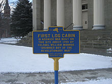 Historic marker of site of first log cabin built in Norwich, NY by Colonel William Monroe. |
NYS Route 12, center of the City of Norwich, NY, on West Side Park by the Chenango County Court House | Norwich, City of, New York | N 42°31’54.2”
W 75°31’28.7” |
FIRST LOG CABIN
Revolutionary Drummer Boy’s House – William Monroe | ||
| Norwich, Town of, New York | FLY MEADOW CREEK |  Historic marker of Fly Meadow Creek, Oxford, NY |
NY State Highway | NYS Route 12, at bridge, south of the City of Norwich, NY | Norwich, Town of, New York | N 42°27’38.9”
W 75°34”28.7” |
FLY MEADOW CREEK | |
| Otselic, Town of, New York | GRACE BROWN |  Historic marker of Grace Brown's family home, Otselic, NY |
Dedicated 2006 Town of Otselic | Stage Road by Brown Lane, Otselic, NY | Otselic, Town of, New York | N 42°39’29.5”
W 75°43’18.3” |
GRACE BROWN
Mar. 20, 1886-July 11, 1906 The family home her untimely death at Big Moose Lake & resulting trial captivated the nation | |
| Otselic, Town of, New York | GRACE BROWN |  Historic marker of Grace Brown, Otselic, NY. The inspiration for Theodore Dreiser's "An American Tragedy". |
Dedicated 2006 Town of Otselic | NYS Route 26, Otselic, NY. Below the junction with Gorge Road, by the steps to the cemetery | Otselic, Town of, New York | N 42°38’44.8”
W 75°46’57.9” |
GRACE BROWN
Whose Life & Death Inspired Theodore Dreiser's "An American Tragedy" Her Final Resting Place in the Valley She loved | |
| Oxford, Village of, New York | SITE OF ANCIENT INDIAN FORT |  Historic marker of Indian Fort found in 1791, Oxford, NY |
State Education Department 1938 | NYS Route 220, in front of Oxford Middle School, Oxford, NY | Oxford, Village of, New York | N 42°26'26.2"
W 26.2"75°35" |
SITE OF ANCIENT INDIAN FORT
In 1791 early settlers found evidence of this fort having been in use for many years. | |
| Oxford, Village of, New York | CONGREGATIONAL CHURCH |  Historic marker of the Congregational Church in the village of Oxford, NY. |
State Education Department 1938 | Fort Hill Park, east side, Oxford, NY | Oxford, Village of, New York | N 42°26'25.8
W 75°35' 45.2 |
CONGREGATIONAL CHURCH
Oldest church edifice standing in the Village. Dedicated July 31, 1823 | |
| Oxford, Village of, New York | FIRST SITE OF OXFORD ACADEMY |  Historic marker of the first site of the Oxford Academy, Oxford, NY. |
State
Education Department 1938 |
NYS Route 220 on Washington Park, Oxford, NY | Oxford, Village of, New York | N 42°39’43.0”
W 75°19’55.8” |
FIRST SITE OF OXFORD ACADEMY
Charted granted 1794. Uri Tracy, first principal. One of the first four charters granted west of Hudson River. | |
| Oxford, Village of, New York | BALDWIN HOME |  Historic marker of the Baldwin Home, Oxford, NY. |
Replaced by Co. Bicentennial “82 | West of Washington Ave. on West State Street, Oxford, NY | Oxford, Village of, New York | N 42°26’33.7”
W 75°35’56.5” |
BALDWIN HOME
Site of home built by Jonathan Baldwin in 1794. Builder 1st school, many houses & 2nd river bridge, moved west of P.O. in 1939. | |
| Oxford, Village of, New York | JUNCTION OF ITHACA-CATSKILL TURNPIKE |  Historic marker of the Ithaca Catskill Turnpike, Oxford, NY. |
State Education Department 1938 | Washington Avenue and Lafayette Park, Oxford, NY | Oxford, Village of, New York | N 42°26’33.2”
W 75°35’53.5” |
JUNCTION OF
Ithaca-Catskill turnpike and the Utica-Binghamton line of Post Coaches. Stage route and mail line formed in 1822 | |
| Oxford, Village of, New York | OXFORD FIRST TOWN MEETING |  Historical marker of Oxford, NY, first town meeting, April 1794, village incorporated April 6, 1806. |
State Education Department 1938 | NY State Route 12 and Lafayette Park, Oxford, NY | Oxford, Village of, New York | N 42°26’32.2”
W 75°35’51.5” |
OXFORD
First town meeting held in April 1794. Incorporated as village . | |
| Oxford, Village of, New York | SITE OF LOG HOUSE | 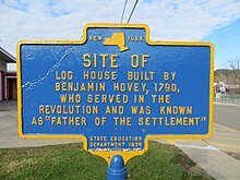 Historic marker at the site of Benjamin Hovey log house, Oxford, NY |
State Education Department 1938 | Park in front of Oxford High School, Oxford, NY | Oxford, Village of, New York | SITE OF LOG HOUSE
Built by Benjamin Hovey 1790, who served in the Revolution and was known as “Father of the Settlement” | ||
| Oxford, Village of, New York | SITE OF ST. PAUL'S EPISCOPAL CHURCH |  Historic marker of the site of St. Paul's Episcopal Church, first church edifice in village of Oxford, NY. |
State Education Department 1938 | Park in front of Oxford High School, Oxford, NY | Oxford, Village of, New York | SITE OF
St. Paul’s Episcopal church, erected in 1816. The first church edifice in the village of Oxford. . | ||
| Oxford, Town of, New York | LYON BROOK BRIDGE | 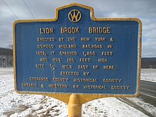 Historic marker of NY & Oswego Midland Railroad, Lyon Brook Bridge, Oxford, NY |
Chenango County Historical Society, Ontario & Western Railway Historical Society | Chenango County Highway 32 at Lyon Brook Road, between Norwich and Oxford, NY | Oxford, Town of, New York | N 42°27'44.7"
W 75°32'54.6" |
LYON BROOK BRIDGE
Erected by the New York & Oswego Midland Railroad in 1869, It spanned 1,200 feet & was 156 feet high. Site ½ mile east of here. | |
| Oxford, Town of, New York | LAKE WARN |  Historic maker of Lake Warn, Oxford, NY |
NYS ED Department 1938 | NYS Route 12 between Brisben and Oxford, NY | Oxford, Town of, New York | N 42°22'49.1
W 75°38'49.3" |
LAKE WARN
According to tradition burial place of Thick Neck, giant Chief of the Antones, a tribe of the Tuscaroras killed by the Oneidas. | |
| Pharsalia, Town of, New York | GAME REFUGE |  Historic marker of Game Refuge, Pharsalia, NY |
NYS Ed & Cons Dept
1955? |
NYS Route 23 at Benedict Hill Road, Pharsalia, NY | Pharsalia, Town of, New York | N 42°40'59"
W 75°31'1" |
1885-1935
GAME REFUGE Pharsalia Refuge 1 mile The first area acquired by New York State for wild life management purposes purchases begun in 1926. | |
| Plymouth, Town of, New York | DEPOT BUILT 1869 |  Historic marker of NY & OM Railroad, Auburn branch, operated by O & W Railroad. Restored in 1979 by the Plymouth Historical Society to use as Town Museum. |
Chenango County Route 16, east of Village of Plymouth, NY | Plymouth, Town of, New York | N 42°37’00.4”
W 75° 36’07.0” |
DEPOT BUILT 1869
by NY & OM RR Auburn Branch operated by O&W 1874-1879 Restored in 1979 by Plymouth Historical Society as a Town Museum | ||
| Preston, Town of, New York | SCHOOL HOUSE |  Historic marker on the site of one room schoolhouse, Ross School District 3, Preston, NY. 1850-1917. |
Chenango Co. Hist. Society | Chenango County Route 10, east of Village of Preston, NY | Preston, Town of, New York | N 42°32’26.2”
W 75°34’53.2” |
SCHOOL SITE
Site one room Ross School Dist 3 ca. 1850-1917 Moved by Kiwanis to Chen Co. Museum Grounds Norwich as Bicentennial Project | |
| Sherburne, Town of, New York | 1885 - 1935
GAME FARM |
 Historic marker of Game Farm in Sherburne, NY |
New York State Education and Conservation Departments, 1935 | NYS Route 80, west of Chenango County Route 23 and Cush Hill Road, Sherburne, NY | Sherburne, Town of, New York | N 42°40’58.0”
W 75°31’00.3” |
1885 - 1935
GAME FARM. Sherburne State Game Farm. Established in 1909. The first in and the oldest in continuous operation the | |
| Smyrna, Town of, New York | ALBANY-ITHACA TURNPIKE 100 |  Historic marker of Albany Ithaca Turnpike, Smyrna, NY |
State Education Department 1936 | NYS Route 80, east of Chenango County Route.14, Smyrna, NY | Smyrna, Town of, New York | N 42°41’36.0”
W 75°33’21.2” |
ALBANY-ITHACA TURNPIKE
A stake driven here marked 100 miles west from Albany on the Albany-Ithaca Turnpike built in 1805 | |
| Sherburne, Town of, New York | FOOTBRIDGE |  Historic marker of Rexford Falls, Sherburne, NY |
Town of Sherburne | NYS Route 80 at Rexford Falls, east of Sherburne, NY | Sherburne, Town of, New York | N 42°40’46.8”
W 75°28’15.9” |
2006
Rexford Falls Footbridge Restoration Herbert H. & Mariea L. Brown Foundation | |
| Sherburne, Town of, New York | WESTERN ORACLE |  Historic marker of the Western Oracle, the first newspaper in Chenango County, NY. |
Replaced by Co. Bicentennial "82 | Chenango County Route. 20, east of railroad track, at Sherburne Four Corners, Sherburne, NY | Sherburne, Town of, New York | N 42°39’03.5”
W 75°34’44.3” |
WESTERN ORACLE
The first newspaper in Chenango County, the Western Oracle published on this site in 1803, by Abraham and Nicholas Romeyn. | |
| Sherburne, Town of, New York | WEST HILL
1802 |
 Historic marker of burial of Colonel William S. Smith, Sherburne, NY |
State Education Department 1936 | NYS Route 80, two miles northwest of Sherburne, NY, at entrance to West Hill Cemetery, Sherburne, NY | Sherburne, Town of, New York | N 42°41’38.5”
W 75°31’59.1” |
West Hill-1802
Colonel William S. Smith. Aide to Washington, owned 150,000 acres hereabout in 1791, married Abigail Adams. Buried at rear, due north. | |
| Smithville, Town of, New York | TARBELL FARMS |  Historic marker of Tarbell Farms, Smithville, NY |
NYSDEC | NYS Route. 41 at Tarbell Road, Smithville, NY | Smithville, Town of, New York | N 42°25’00.9”
W 75°49’56.5” |
1875-1963
TARBELL FARMS Site of a Renowned Guernsey Dairy Farm Golden Guernsey milk was once shipped to New York Citys finest restaurants | |
| Smyrna, Town of, New York | BRIGHAM YOUNG |  Historic marker of the boyhood home of Brigham Young. Cole Road, Smyrna, NY |
Chenango Co. Bicentennial ‘82
(Replaced after 1981) |
Chenango County Route 21, at Cole Road, Smyrna, NY | Smyrna, Town of, New York | N 42°39’03.5”
W 75°34’44.3” |
BRIGHAM YOUNG
Site of boyhood home of Brigham Young, Mormon leader, is one-half mile no. on Cole Rd. the family went on to Western N.Y. | |
| Oxford, Town of, New York | FORT HILL MILL |  Historic marker of Fort Hill mill, Oxford, NY |
State Education Department 1938 | Chenango River bridge at the Oxford Fire Department, Main Street, Oxford, NY | Oxford, Town of, New York | N 42°26'28.6"
W 75°35'46.1" |
FORT HILL MILL
Built in 1794 by Theodore Burr and Jonathan Baldwin. |
See also[]
- List of New York State Historic Markers
- National Register of Historic Places listings in New York
- List of National Historic Landmarks in New York
References[]
- ^ a b "New York State Historic Markers". New York State Historic Markers. New York State Museum. 2009-07-15. Archived from the original on 2013-03-24.
- Chenango County, New York
- New York State Historic Markers