List of airports in Newfoundland and Labrador

Newfoundland and Labrador
This is a list of airports in Newfoundland and Labrador. It includes all Nav Canada certified and registered water and land airports, aerodromes and heliports in the Canadian province of Newfoundland and Labrador.[1][2] Airport names in italics are part of the National Airports System.[3]
List of airports and heliports[]

Wabush Airport

Stephenville International Airport

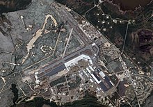
St. John's International Airport
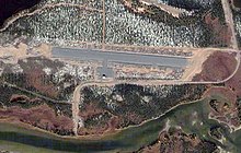
CFB Goose Bay

Gander International Airport
Natuashish Airport

Goose (Otter Creek) Water Aerodrome
The list is sorted by the name of the community served; click the sort buttons in the table header to switch listing order.

Defunct airports[]
References[]
- ^ Canada Flight Supplement. Effective 0901Z 16 July 2020 to 0901Z 10 September 2020.
- ^ Nav Canada's Water Aerodrome Supplement. Effective 0901Z 26 March 2020 to 0901Z 22 April 2021.
- ^ https://www.tc.gc.ca/en/services/aviation/operating-airports-aerodromes/list-tc-airports.html#National_Airports_System National Airports System
- ^ https://www.gov.nl.ca/eccm/files/env-assessment-projects-y2010-1516-1516-registration.pdf[bare URL PDF]
- ^ Davis Inlet at Great Circle Mapper
- ^ "GEOSCAN Search Results: Fastlink".
- ^ https://www.gov.nl.ca/eccm/files/089758-RPT9-FINAL-Border-Beacon-Site-212-Report.pdf[bare URL PDF]
- ^ "Ross Bay Junction - Canada".
| By name | |
|---|---|
| By location indicator | |
| By province/territory | |
| By area | |
| National Airports System | |
| Related | |
| |
Categories:
- Airports in Newfoundland and Labrador
- Lists of airports in Canada (provincial)
- Newfoundland and Labrador-related lists
- Lists of buildings and structures in Newfoundland and Labrador