List of airports in Sri Lanka

Map of Sri Lanka
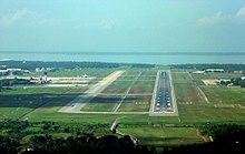
Colombo's Bandaranaike International Airport is the busiest airport in the country and one of the busiest airports in South Asia. It was estimated to handle over 10.5 million passengers in 2018.
This is a list of airports in Sri Lanka.
Airport[]
Airport names shown in bold indicate the facility has scheduled passenger service on a commercial airline.
International airports[]
| Location served | Province | ICAO | IATA | Airport name | Usage | Runway(s) | Coordinates | Total passengers |
|---|---|---|---|---|---|---|---|---|
| Batticaloa | Eastern | VCCB | BTC | Batticaloa International Airport | Public/military | 1,560 m (5,120 ft) | 07°42′18″N 81°40′38″E / 7.70500°N 81.67722°E | NA |
| Colombo | Western | VCBI | CMB | Bandaranaike International Airport | Public/military | 3,350 m (10,990 ft) 4,000 m (13,000 ft) |
07°10′52″N 79°53′06″E / 7.18111°N 79.88500°E | 2,372,928 (2020) |
| Colombo | Western | VCCC | RML | Ratmalana International Airport | Public/military | 1,830 m (6,000 ft) | 06°49′23″N 79°53′12″E / 6.82306°N 79.88667°E | 2,336,897 (2016) |
| Hambantota | Southern | VCRI | HRI | Mattala Rajapaksa International Airport | Public | 3,500 m (11,500 ft) | 06°17′10″N 81°07′32″E / 6.28611°N 81.12556°E | 1,536 (2019) |
| Jaffna | Northern | VCCJ | JAF | Jaffna International Airport | Public/military | 2,375 m (7,792 ft) | 09°47′32″N 80°04′12″E / 9.79222°N 80.07000°E | NA |

Domestic airports[]
Waterdromes[]
| Location served | Province | ICAO | IATA | Airport name | Usage | Runway(s) | Coordinates |
|---|---|---|---|---|---|---|---|
| Ampara | Eastern | AFK | |||||
| Arugam Bay | Eastern | AYY | |||||
| Batticaloa | Eastern | ||||||
| Bentota | Southern | BJT | Bentota River Airport | ||||
| Central | NUF | Castlereigh Reservoir Waterdrome | |||||
| Colombo-Dandugama | Western | DGM | |||||
| Colombo-Peliyagoda | Western | KEZ | Kelani River-Peliyagoda Waterdrome | ||||
| Dambulla | Central | DBU | (Dambulu Oya Tank) | ||||
| Dikwella | Southern | DIW | Mawella Lagoon Airport | ||||
| Hambantota | Southern | HBT | |||||
| Iranamadu | Northern | IRU | |||||
| Jaffna | Northern | ||||||
| Kalpitiya | North Western | ||||||
| Kandy-Polgolla | Central | KDZ | |||||
| Kandy-Victoria | Central | KDW | |||||
| Koggala | Southern | KCT | |||||
| Nuwara Eliya | Central | NUA | Lake Gregory Waterdrome | ||||
| Pasikudah | Eastern | PQD | |||||
| Tissamaharama | Southern | TTW | |||||
| Trincomalee | Eastern | THW |
See also[]

Hambantota's Mattala Rajapaksa International Airport is the second largest airport.
- List of Sri Lankan air force bases
- List of airports by ICAO code: V § VC – Sri Lanka
- Wikipedia:WikiProject Aviation/Airline destination lists: Asia#Sri Lanka
References[]
- "Aeronautical Information Publication". Aeronautical Information Services of Sri Lanka. Archived from the original on 2016-01-24. Retrieved 2016-01-24.
- "Aerodrome Index Chart" (PDF). Aeronautical Information Services of Sri Lanka. Archived from the original (PDF) on 2016-01-24. Retrieved 2016-01-24.
- "Location Indicators by State" (PDF). International Civil Aviation Organization. 17 September 2010. p. 100.
- "Airline and Airport Code Search". International Air Transport Association.
- "Code for Trade and Transport Locations (UN/LOCODE)". United Nations Economic Commission for Europe.
- "Search for Locations – country:LK". Great Circle Mapper.
- "Airports in Sri Lanka". World Aero Data.
- "Airports in Sri Lanka". Airport & Aviation Services (Sri Lanka) Limited.
List of airports in Asia | |
|---|---|
| Sovereign states |
|
| States with limited recognition | |
| Dependencies and other territories |
|
| |
Categories:
- Airports in Sri Lanka
- Lists of airports by country
- Lists of buildings and structures in Sri Lanka
- Sri Lanka transport-related lists
- Lists of airports in Asia