List of cities and towns in the San Francisco Bay Area
From Wikipedia, the free encyclopedia
Wikipedia list article
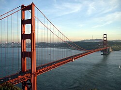
San Francisco Bay Area
The San Francisco Bay Area, commonly known as the Bay Area, is a metropolitan region surrounding the San Francisco Bayestuaries in Northern California. According to the 2010 United States Census, the region has over 7.1 million inhabitants and approximately 6,900 square miles (18,000 km2) of land.[1] The region is home to three major cities: San Francisco, Oakland and, the largest, San Jose.
The Bay Area has been inhabited since antiquity, first by the Ohlone and Miwok peoples, followed by the Spanish, who first arrived in 1769 and established the area's first mission, Mission San Francisco de Asís, in 1776.[2][3][4] After being ceded to the United States in 1848, the Bay Area grew immensely due to the California Gold Rush, establishing itself as one of the most important regions on the West Coast. Today, the Bay Area is the home of Silicon Valley, Wine Country, and numerous companies, universities, bridges, airports, and parks.
The Bay Area consists of nine counties (Alameda, Contra Costa, Marin, Napa, San Francisco, San Mateo, Santa Clara, Solano, and Sonoma) and 101 municipalities.[5] One, San Francisco, is a consolidated city–county. California law makes no distinction between "city" and "town", and municipalities may use either term in their official names.[6] The first municipalities to incorporate were Benicia and San Jose on March 27, 1850, while the most recent was Oakley on July 1, 1999.[7] The largest municipality by population and land area is San Jose with 1,013,240 residents and 178.26 square miles (461.7 km2). The smallest by population is Colma with 1,507 people,[8] while the smallest by land area is Belvedere at 0.52 square miles (1.3 km2).[9]
^Kroeber, Alfred L. (1925). Handbook of the Indians of California. Washington, DC: Smithsonian Institution, Bureau of American Ethnology. pp. 273, 462.
^ ab"Explore Census Data". United States Census Bureau. United States Census Bureau. Retrieved December 5, 2021.
^ ab"Places". 2020 U.S. Gazetteer Files. United States Census Bureau. Retrieved December 5, 2021.
^Long, Percy V. (1911). "Consolidated City and County Government of San Francisco". Proceedings of the American Political Science Association. 8 (Eighth Annual Meeting): 109–121. doi:10.2307/3038399. JSTOR3038399.


 San Francisco Bay Area portal
 Cities portal
 California portal


