| Image
|
Crossing
|
Location
|
Opened
|
Coordinates
|
Notes
|

|
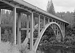
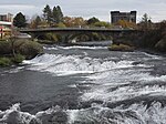
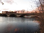
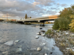
Spokane River Bridge at Fort Spokane
 SR 25 SR 25
|
Fort Spokane
|
1941[1]
|
 47°54′28″N 118°19′03″W / 47.907916°N 118.317557°W / 47.907916; -118.317557 47°54′28″N 118°19′03″W / 47.907916°N 118.317557°W / 47.907916; -118.317557
|
NRHP
|
|
|
Little Falls Road
|
Little Falls
|
|
47°49′44″N 117°55′06″W / 47.829008°N 117.918408°W / 47.829008; -117.918408
|
|
|
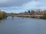
Spokane River Bridge at Long Lake Dam
 SR 231 SR 231
|
Long Lake
|
1949[1]
|
47°50′19″N 117°51′09″W / 47.838726°N 117.852442°W / 47.838726; -117.852442
|
NRHP
|
|
Charles Road
|
Nine Mile Falls
|
|
47°46′37″N 117°32′41″W / 47.776938°N 117.544859°W / 47.776938; -117.544859
|
|
|
Seven Mile Road
|
|
47°44′26″N 117°31′10″W / 47.740640°N 117.519485°W / 47.740640; -117.519485
|
|
|
|
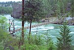
Bowl & Pitcher Footbridge
|
Spokane
|
1941[1]
|
47°41′48″N 117°29′52″W / 47.696724°N 117.497694°W / 47.696724; -117.497694
|
In Riverside State Park
|
|
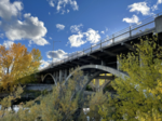
T. J. Meenach Bridge
Whistalks Way
|
|
47°40′48″N 117°27′10″W / 47.679870°N 117.452659°W / 47.679870; -117.452659
|
Carries Spokane River Centennial Trail[2]
|

|
Sandifur Memorial Footbridge
|
|
47°39′24″N 117°27′16″W / 47.656671°N 117.454329°W / 47.656671; -117.454329
|
|

|
Maple Street Bridge
|
1958[1]
|
47°39′39″N 117°26′07″W / 47.660765°N 117.435354°W / 47.660765; -117.435354
|
|
|
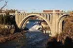
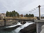
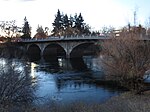
Monroe Street Bridge
|
1911[1]
|
47°39′38″N 117°25′36″W / 47.660596°N 117.426688°W / 47.660596; -117.426688
|
Replaced 1889 and 1892 bridges[1]
|

|
Post Street
|
1917[1]
|
47°39′44″N 117°25′28″W / 47.662157°N 117.424328°W / 47.662157; -117.424328
|
Being replaced as of 2021[3]
|
|
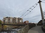
Upper Falls Suspension Footbridges
|
1974
|
47°39′49″N 117°25′23″W / 47.663718°N 117.423008°W / 47.663718; -117.423008
|
Crosses north branch in Riverfront Park
|
|
47°39′46″N 117°25′22″W / 47.662808°N 117.422772°W / 47.662808; -117.422772
|
Crosses south branch in Riverfront Park
|
|
Howard Street Bridges
|
|
47°39′51″N 117°25′15″W / 47.664296°N 117.420787°W / 47.664296; -117.420787
|
Crosses north branch in Riverfront Park
|

|
1916[1][4]
|
47°39′47″N 117°25′16″W / 47.663060°N 117.421034°W / 47.663060; -117.421034
|
Crosses south branch in Riverfront Park
|

|
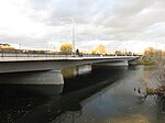
Washington Street
|
1985[1]
|
47°39′48″N 117°25′04″W / 47.663398°N 117.417891°W / 47.663398; -117.417891
|
Replaced 1908 bridge.[1] Passes through Riverfront Park
|
|
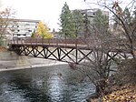
Lou Barbieri Footbridge
|
|
47°39′48″N 117°24′58″W / 47.663253°N 117.416173°W / 47.663253; -117.416173
|
Crosses north branch Riverfront Park
|

|
  Division Street Division Street
|
|
47°39′46″N 117°24′40″W / 47.662703°N 117.411167°W / 47.662703; -117.411167
|
Carries U.S. Route 2
|

|
Don Kardong Footbridge
|
1920s[1]
|
47°39′48″N 117°24′11″W / 47.663441°N 117.403000°W / 47.663441; -117.403000
|
Replaced 1892 bridge; converted to footbridge in1988.[1] Carries Spokane River Centennial Trail[2]
|
|
Spokane Falls Boulevard
|
|
47°39′43″N 117°24′04″W / 47.661887°N 117.400994°W / 47.661887; -117.400994
|
|
|
 Hamilton Street Hamilton Street
|
|
47°39′36″N 117°23′46″W / 47.660008°N 117.395976°W / 47.660008; -117.395976
|
|
|
Trent Avenue
|
1910[1]
|
47°39′43″N 117°23′37″W / 47.661887°N 117.393508°W / 47.661887; -117.393508
|
Being replaced as of 2021[5]
|

|
Iron Bridge
|
1911[1]
|
47°39′52″N 117°23′32″W / 47.664479°N 117.392122°W / 47.664479; -117.392122
|
Converted to footbridge in 2012[1]
|
|
BNSF Chewelah Subdivision
|
|
47°40′00″N 117°23′27″W / 47.666761°N 117.390781°W / 47.666761; -117.390781
|
|
|
Mission Avenue
|
1909[1]
|
47°40′18″N 117°23′16″W / 47.671764°N 117.387647°W / 47.671764; -117.387647
|
|
|
Greene Street
|
1955[1]
|
47°40′42″N 117°21′50″W / 47.678366°N 117.363779°W / 47.678366; -117.363779
|
|
|
|
Argonne Road
|
Millwood
|
2004[1]
|
47°41′23″N 117°16′58″W / 47.689833°N 117.282771°W / 47.689833; -117.282771
|
Replaced 1920 bridge[1]
|

|
Plante's Ferry Footbridge
|
Spokane Valley
|
|
47°41′35″N 117°15′02″W / 47.692922°N 117.250426°W / 47.692922; -117.250426
|
Carries Spokane River Centennial Trail[2]
|

|
Trent Avenue
|
|
47°41′30″N 117°14′06″W / 47.691746°N 117.234908°W / 47.691746; -117.234908
|
|

|
BNSF Spokane Subdivision
|
|
47°41′25″N 117°13′57″W / 47.690394°N 117.232454°W / 47.690394; -117.232454
|
|

|
UP Spokane International Railroad
|
|
47°40′38″N 117°12′17″W / 47.677336°N 117.204855°W / 47.677336; -117.204855
|
|

|
Sullivan Road
|
|
47°40′21″N 117°11′48″W / 47.672498°N 117.196550°W / 47.672498; -117.196550
|
|

|
Barker Road
|
|
47°40′41″N 117°09′14″W / 47.678091°N 117.153950°W / 47.678091; -117.153950
|
|
|
Harvard Road
|
Liberty Lake and
Otis Orchards-East Farms
|
|
47°40′59″N 117°06′41″W / 47.683188°N 117.111264°W / 47.683188; -117.111264
|
|
|
|
Appleway Avenue
|
Otis Orchards-East Farms
|
|
47°41′55″N 117°02′40″W / 47.698647°N 117.044382°W / 47.698647; -117.044382
|
|
|
|
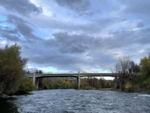
 I-90 I-90
|
State Line, Idaho
|
|
47°41′49″N 117°02′27″W / 47.696811°N 117.040830°W / 47.696811; -117.040830
|
|
|
|
North Idaho Centennial Trail
|
|
47°41′45″N 117°02′22″W / 47.695815°N 117.039353°W / 47.695815; -117.039353
|
Carries the Spokane River Centennial Trail[6]
|
|
|
Post Falls Dam Bridge
|
Post Falls, Idaho
|
|
47°42′41″N 116°57′22″W / 47.711315°N 116.956128°W / 47.711315; -116.956128
|
Crosses side channel
|

|
Spokane Street
|
|
47°42′14″N 116°56′56″W / 47.704011°N 116.948983°W / 47.704011; -116.948983
|
|

|
 US 95 US 95
|
Coeur d'Alene, Idaho
|
|
47°41′10″N 116°47′58″W / 47.685992°N 116.799379°W / 47.685992; -116.799379
|
|


