List of cultural monuments in Lučenec
This list contains the 59 buildings and structures officially designated as cultural monuments in Lučenec, Slovakia.
| Photography | Name | Register number ÚSKP | Address/Coordinates | Notes |
|---|---|---|---|---|
 |
Jewish Mortuary | 606-458/0 | Vajanský street | |

|
Memorial | 606-516/0 | Monument for Romanian soldiers killed in World War II. | |

|
Ráday Family Crypt | 606-2741/0 | Lučenec cemetery | |

|
Mansion | 606-3479/0 | Zámocká street 54 = 48°20′2.26″N 19°40′59.2″E / 48.3339611°N 19.683111°E | |

|
Synagogue | 606-3507/0 | Ady street 4 = 48°19′28.02″N 19°40′9.3″E / 48.3244500°N 19.669250°E | The largest synagogue in the Slovak Republic |
|
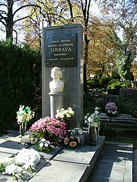
Grave with a tombstone | 606-519/0 | Lučenec cemetery | Grave of Slovak writer Timrava (Božena Slančíková) |

|
Crypt | 606-10455/0 | Lučenec cemetery | Andrejcsik Family Crypt |

|
Mansion | 606-10452/0 | Filakovská street 12 - 48°19′32.45″N 19°40′14.84″E / 48.3256806°N 19.6707889°E | Szilassy Mansion |

|
Town hall | 606-3488/0 | Dr. Herz street 1 - 48°19′38.96″N 19°40′5.59″E / 48.3274889°N 19.6682194°E | Former town hall |

|
Burgher's house | 606-3494/0 | Dr. Herz street 12 = 48°19′38.71″N 19°40′1.24″E / 48.3274194°N 19.6670111°E | |

|
Office building | 606-3483/0 | Dr. Herz street 14 = 48°19′38.68″N 19°39′59.69″E / 48.3274111°N 19.6665806°E | Currently, the district court |

|
Rakottay villa | 606-10958/0 | Jókai street 7 = 48°19′52″N 19°40′11.32″E / 48.33111°N 19.6698111°E | |

|
Villa | 606-11072/1 | Jókai street 13 = 48°19′53.87″N 19°40′3.22″E / 48.3316306°N 19.6675611°E | Currently, kindergarten |

|
Summer-house | 606-11072/2 | Jókai street 13 = 48°19′53.87″N 19°40′3.22″E / 48.3316306°N 19.6675611°E | |

|
parcel wall | 606-11072/3 | Jókai street 13 = 48°19′53.87″N 19°40′3.22″E / 48.3316306°N 19.6675611°E | |

|
Railing with columns | 606-11072/4 | Jókai street 13 = 48°19′53.87″N 19°40′3.22″E / 48.3316306°N 19.6675611°E | |

|
Set of columns | 606-11072/5 | Jókai street 13 = 48°19′53.87″N 19°40′3.22″E / 48.3316306°N 19.6675611°E | |

|
Bowl with stand | 606-11072/6 | Jókai street 13 = 48°19′53.87″N 19°40′3.22″E / 48.3316306°N 19.6675611°E | |

|
Calvinist church | 606-454/0 | J. Kármán street 1 = 48°19′43.64″N 19°40′10.11″E / 48.3287889°N 19.6694750°E | |

|
Bank | 606-3489/0 | J. Kármán street 2 = 48°19′43.86″N 19°40′9.08″E / 48.3288500°N 19.6691889°E | Currently, Novohradská library |

|
Pedagogy school | 606-3502/0 | Komenský street 12 = 48°19′34.07″N 19°39′57.89″E / 48.3261306°N 19.6660806°E | |

|
Evangelical church | 606-453/0 | Komenský street 14 = 48°19′32.78″N 19°39′58.02″E / 48.3257722°N 19.6661167°E | |

|
Evangelical parsonage | 606-3503/0 | Komenský street 16 = 48°19′31.87″N 19°39′57.02″E / 48.3255194°N 19.6658389°E | |

|
Roman Catholic Church | 606-452/0 | Kubínyi square = 48°19′41.56″N 19°39′10.39″E / 48.3282111°N 19.6528861°E | |

|
Burgher's house | 606-3484/0 | Kubínyi square 1 = 48°19′39.07″N 19°40′10.49″E / 48.3275194°N 19.6695806°E | |

|
The Roman Catholic parish | 606-456/0 | Kubínyi square 2 = 48°19′39.61″N 19°40′10.63″E / 48.3276694°N 19.6696194°E | |

|
Burgher's house | 606-457/0 | Kubínyi square 3 = 48°19′40.12″N 19°40′10.81″E / 48.3278111°N 19.6696694°E | |

|
Burgher's house | 606-3485/0 | Kubínyi square 4 = 48°19′40.62″N 19°40′10.96″E / 48.3279500°N 19.6697111°E | |

|
Burgher's house | 606-3490/0 | Kubínyi square 5 = 48°19′41.16″N 19°40′11.14″E / 48.3281000°N 19.6697611°E | |

|
Primary school | 606-3491/0 | Kubínyi square 6 = 48°19′41.66″N 19°40′11.28″E / 48.3282389°N 19.6698000°E | Former girls School |

|
Burgher's house | 606-3487/0 | Kubínyiho náměstí 7 = 48°19′42.17″N 19°40′11.42″E / 48.3283806°N 19.6698389°E | |

|
Burgher's house | 606-3486/0 | Kubínyi square 8 = 48°19′39.76″N 19°40′8.76″E / 48.3277111°N 19.6691000°E | |

|
Banka | 606-3492/0 | Kubínyi square 9 = 48°19′41.05″N 19°40′9.08″E / 48.3280694°N 19.6691889°E | Former Dunajská bank |

|
Burgher's house | 606-3493/0 | Kubínyi square 10 = 48°19′42.74″N 19°40′9.12″E / 48.3285389°N 19.6692000°E | |

|
Burgher's house | 606-3495/0 | Masaryk street 2 = 48°19′43.1″N 19°40′8.51″E / 48.328639°N 19.6690306°E | |

|
Burgher's house | 606-3496/0 | Masaryk street 4 = 48°19′43.36″N 19°40′7.68″E / 48.3287111°N 19.6688000°E | |

|
Burgher's house | 606-3497/0 | Masaryk street 6 = 48°19′43.57″N 19°40′6.82″E / 48.3287694°N 19.6685611°E | |

|
Burgher's house | 606-3498/0 | Masaryk street 8 = 48°19′43.82″N 19°40′5.99″E / 48.3288389°N 19.6683306°E | |

|
Burgher's house | 606-3499/0 | Masaryk street 10 = 48°19′44.04″N 19°40′5.12″E / 48.3289000°N 19.6680889°E | |

|
Burgher's house | 606-3500/0 | Masaryk street 28 = 48°19′46.09″N 19°39′56.34″E / 48.3294694°N 19.6656500°E | |

|
Burgher's house | 606-3501/0 | Masaryk street 29 = 48°19′47.42″N 19°39′49.82″E / 48.3298389°N 19.6638389°E | |

|
Burgher's house | 606-11073/0 | Masaryk street 34 = 48°19′46.6″N 19°39′53.86″E / 48.329611°N 19.6649611°E | |

|
Former YMCA | 606-10806/0 | Novohrad street 2 = 48°19′48.79″N 19°39′46.8″E / 48.3302194°N 19.663000°E | |

|
Reduta - Lučenec | 606-3482/0 | Vajanský street 2 = 48°19′38.68″N 19°40′9.57″E / 48.3274111°N 19.6693250°E | |

|
Memorial plaque | 606-517/0 | Vajanský street 5 = 48°19′36.88″N 19°40′7.5″E / 48.3269111°N 19.668750°E | Memorial plaque for Hungarian poet Sándor Petőfi |

|
Burgher's house | 606-10451/0 | Vajanský street 7 = 48°19′36.41″N 19°40′7.36″E / 48.3267806°N 19.6687111°E | |

|
Burgher's house | 606-3504/0 | Vajanský street 14 = 48°19′35.26″N 19°40′7.82″E / 48.3264611°N 19.6688389°E | |

|
Administrativní budova | 606-3505/0 | Vajanský street 16 = 48°19′34.72″N 19°40′7.68″E / 48.3263111°N 19.6688000°E | |

|
Burgher's house | 606-10765/0 | Dr. Voda street 2 = 48°19′45.3″N 19°39′53.32″E / 48.329250°N 19.6648111°E | |

|
Memorial plaque | 606-518/0 | Zvolenská street 10 = 48°20′11.15″N 19°39′40.14″E / 48.3364306°N 19.6611500°E | Memorial plaque for Slovak writer Timrava (Božena Slančíková) |

|
Cafe | 606-3506/0 | Železničná street 1 = 48°19′47.78″N 19°39′57.24″E / 48.3299389°N 19.6659000°E | Currently, OTP Bank |

|
Burgher's house | 606-11249/0 | Železničná street 16 = 48°19′52.21″N 19°39′57.02″E / 48.3311694°N 19.6658389°E | |

|
Mansion | 606-470/1 | Dolná Slatinka 4 = 48°20′58.99″N 19°41′22.88″E / 48.3497194°N 19.6896889°E | |

|
Park | 606-470/2 | Dolná Slatinka 4 = 48°20′58.99″N 19°41′22.88″E / 48.3497194°N 19.6896889°E | |

|
Mansion | 606-469/1 | Jegorov street 3 = 48°20′32.82″N 19°40′52″E / 48.3424500°N 19.68111°E | |

|
Park | 606-469/2 | Jegorov street 3 = 48°20′32.82″N 19°40′52″E / 48.3424500°N 19.68111°E | |

|
Ruins of mansion | 606-471/1 | Jegorov street 10 = 48°20′34.12″N 19°40′48.29″E / 48.3428111°N 19.6800806°E | |

|
Remains of the park | 606-471/2 | Jegorov street 10 = 48°20′34.12″N 19°40′48.29″E / 48.3428111°N 19.6800806°E | |

|
Memorial plaque | 606-522/0 | Gemerská street 32 = 48°20′21.66″N 19°40′44.98″E / 48.3393500°N 19.6791611°E | Memorial plaque for Czech writer Alois Jirásek |
| Wikimedia Commons has media related to Cultural heritage monuments in Lučenec. |
Sources[]
- English translation of the Slovak Wikipedia
Categories:
- Buildings and structures in Banská Bystrica Region
- Heritage registers in Slovakia