List of earthquakes in Cuba
Cuba is located in an area with several active fault systems which produce on average about 2000 seismic events each year.[1] While most registered seismic events pass unnoticed, the island has been struck by a number of destructive earthquakes over the past four centuries, including several major quakes with a magnitude of 7.0 or above.
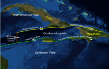
Approximately 70% of seismic activity in Cuba emanates from the Oriente fault zone, located in the Bartlett-Cayman fault system which runs along the south-eastern coast of Cuba and marks the tectonic boundary between the North American Plate and the Caribbean Plate.[2] The 12 currently active faults in Cuba also include the , and faults.[2] Destructive earthquakes originating from the Oriente fault occurred in 1766 (MI= 7.6), 1852 (MI = 7.2) and 1932 (Ms = 6.75).[3] Some studies suggested there is a high probability the Oriente fault would produce a magnitude 7 earthquake,[4] this happening in January 2020, with a magnitude of 7.7, the highest registered in this country's history.
This list is incomplete; you can help by . (January 2010) |
Notable earthquakes in recent Cuban history include the following:
| Name | Date | Epicentre | M | Intensity | Depth | Notes | Deaths |
|---|---|---|---|---|---|---|---|
| August 1578 |
Santiago de Cuba[1] | 6.8 | VIII | 30 km | Magnitude estimated at 6.8 ML on the Richter magnitude scale, intensity at VIII EMS-98.[1] | ||
| 1580-12-19 |
Santiago de Cuba[5] | ||||||
| October 1632 |
Santiago de Cuba[6] | ||||||
| 1675-02-11 |
Santiago de Cuba[1][7] | 5.8 | VII | 30 km | Magnitude estimated at 5.8 ML on the Richter magnitude scale, intensity at VII EMS-98.[1] | ||
| 1678-02-11 14:59 |
Santiago de Cuba[7] | 6.8 | VIII | 30 km | Magnitude estimated at 6.8 ML on the Richter magnitude scale, intensity at VIII EMS-98.[1] | ||
| 1679-02-11 |
Santiago de Cuba[7] | ||||||
| 1682 |
Santiago de Cuba[7] | 5.8 | VII | 30 km | Magnitude estimated at 5.8 ML on the Richter magnitude scale, intensity at VII EMS-98.[1] | ||
| July 1693 |
Havana[8] | "1,500 houses thrown down" | |||||
| 1757-12-14 |
Santiago de Cuba[9] | ||||||
| 1766-06-11 05:14 |
Santiago de Cuba[10] | 7.6 MI [3] | IX | 35 km | Magnitude estimated at 7.6 ML on the Richter magnitude scale, intensity at IX EMS-98.[1] | 120 | |
| 1826-09-18 09:26 |
Santiago de Cuba[11] | 5.8 | VII | 30 km | Magnitude estimated at 5.8 ML on the Richter magnitude scale, intensity at VII EMS-98.[1] | ||
| 1842-07-07 |
Santiago de Cuba[1] | 6.0 | VII | 30 km | Magnitude estimated at 6.0 ML on the Richter magnitude scale, intensity at VII EMS-98.[1] | ||
| 1852-08-20 14:05 UTC |
Santiago de Cuba[10][12] | 7.2 MI [3] | IX | 30 km | Intensity estimated at IX EMS-98,[1] with 26 heavy aftershocks. Caused severe damage to churches and other buildings in Santiago de Cuba, as well as landslides in the Sierra Maestra region. Shaking felt in the whole of eastern Cuba, up to the islands of Jamaica and Hispaniola.[13] | ||
| 1852-11-26 08:37 GMT |
Santiago de Cuba, Sierra Maestra[1][14] | 7.0 | VIII | 35 km | |||
| 1858-01-28 22:04 |
Santiago de Cuba[1] | 6.5 | VII | 30 km | |||
| 1880-01-23 04:39 |
San Cristóbal/Vuelta Abajo (Pinar del Río) [1][15][16] | 6.0 | VIII | 15 km | A series of severe shock waves originating from western Cuba were also felt in the town of Key West (Florida), and included a strong earthquake on 23 January 1880 in San Cristóbal, Pinar del Río at 4 a.m.[16] | ||
| 1903-09-22 08:09 |
Santiago de Cuba[1] | 5.7 | VII | 30 km | |||
| 1906-06-22 07:09 |
Santiago de Cuba[1] | 6.2 | VII | 30 km | |||
| 1914-02-28 05:19 |
Gibara[1] | 6.2 | VII | 32 km | |||
| 1914-12-25 05:19 |
Santiago de Cuba[1] | 6.7 | VII | 30 km | |||
| 1932-02-03 |
20°00′00″N 75°48′00″W / 20.000°N 75.800°W Santiago de Cuba[17] |
6.75 mb[3] | VIII | Intensity estimated at VIII EMS-98.[1] 8[17] – 1500[18] deaths, 300 injured. 80% of buildings in Santiago de Cuba affected.,[17] with damage totaling 15 million Pesos.[13] | 8 | ||
| 1947-08-07 00:40:20 hrs |
19°45′N 75°19′W / 19.75°N 75.32°W |
6.8 | VIII | 50 km | Magnitude estimated at 6.8 ML and intensity VIII EMS-98.[1] | ||
| 1992-05-25 16:55:04 UTC |
19°36′47″N 77°52′19″W / 19.613°N 77.872°W Cabo Cruz, Pilón–Manzanillo[20] |
6.9 Ms[21] | VII | 23 km | A strong earthquake struck the Cabo Cruz sector, leaving 40 people injured and more than 820 buildings damaged in the Pilon-Manzanillo area.[22] | - | |
| 2020 Caribbean earthquake | 2020-01-28
14:10 UTC |
19.419°N 78.756°W
Caribbean Sea |
7.7 Mw | VI | 14.9 km | One house collapsed and more than 300 were damaged.[23] | 0 |

Intensity= Intensity on the European Macroseismic Scale (EMS-98), which is somewhat similar to the Modified Mercalli scale (MM)
See also[]
References[]
- ^ Jump up to: a b c d e f g h i j k l m n o p q r s t u Oficina Nacional de Estadísticas, 2009
- ^ Jump up to: a b Cotilla, 2007
- ^ Jump up to: a b c d Alvarez 1999:2
- ^ Rubio, 1985
- ^ Milne, 1912: 30
- ^ Milne, 1912: 32
- ^ Jump up to: a b c d Milne, 1912: 36
- ^ Milne, 1912: 37
- ^ Milne, 1912: 44
- ^ Jump up to: a b Cotilla, 2003
- ^ Milne, 1912: 54
- ^ Milne, 1912: 62
- ^ Jump up to: a b ONE, 2006
- ^ Milne 1912: 63
- ^ Milne 1912: 80
- ^ Jump up to: a b "Florida. Earthquake History". Retrieved 2010-01-25.
- ^ Jump up to: a b c "Significant Earthquake". National Geophysical Data Center. Retrieved 2010-01-25.
- ^ Earthquake in Cuba. 1500 Deaths reported. The Sidney Morning Herald, Feb. 4, 1932.
- ^ A Chronological History of the U.S. Navy Cruiser U.S.S. LITTLE ROCK
- ^ USGS. "Significant Earthquakes of the World, 1992". Retrieved 2010-01-25.
- ^ Pierrot et al, 1998
- ^ Earthquake in Cuba Injures 40 and Destroys 100 Homes
- ^ OnCuba Staff (4 February 2020). "Earthquake-damaged buildings in Cuba were in "poor condition"". On Cuba News. Retrieved 27 November 2020.
Other sources[]
- Alvarez, Leonardo; Giuliano F. Panza; Franco Vaccari; Bertha E. Gonzalez (December 1999), "Modelling of seismic ground motion in Santiago de Cuba city from earthquakes in Oriente fault seismic zone", Pure and Applied Geophysics, Trieste/Miramare: The Abdus Salara International Centre for Theoretical Physics, 158 (9–10): 1763, Bibcode:2001PApGe.158.1763A, doi:10.1007/PL00001242
- Blanco Moreno, Jesús; Joaquín Proenza Fernández (2000). "Sistematización tectonoestratigráfica de Cuba centro oriental". Revista Minería y Geología. XVII (1): 35–45. Archived from the original on 2011-07-18. Retrieved 2010-01-25.
- Calais, E.; J. Perrot; B. Mercier de Lépinay (1997). "Tectonic and Kinematic Regime along the Northern Caribbean Plate Boundary: New Insights from Broad-band Modeling of the May 25, 1992, Ms = 6.9 Cabo Cruz, Cuba, Earthquake". Pure and Applied Geophysics. 149 (3): 475–487. Bibcode:1997PApGe.149..475P. doi:10.1007/s000240050036.
- Calais, E.; J. Perrot; B. Mercier de Lépinay (1998). "Strike-slip tectonics and seismicity along the northern Caribbean plate boundary from Cuba to Hispaniola" (PDF). Geological Society of America Special Papers. Geological Society of America. 326 (326): 125–169. doi:10.1130/0-8137-2326-4.125. ISBN 978-0-8137-2326-6. Archived from the original (PDF) on 2011-07-25. Retrieved 2010-01-25.
- Cotilla Rodriguez, M.O. (2003). "The Santiago de Cuba earthquake of 11 June 1766: Some new insights" (PDF). Geofísica Internacional. 42 (4): 589–602. Retrieved 2010-01-25.
- Cotilla Rodriguez, M.O.; Franzke, H.J.; Córdoba Barba, D. (June 2007). "Seismicity and seismoactive faults of Cuba". Russian Geology and Geophysics. 48 (6): 505–522. Bibcode:2007RuGG...48..505C. doi:10.1016/j.rgg.2006.08.004.
- Lander, James F. (1997). "Caribbean Tsunamis: An initial history" (PDF). In Ahmad, Rafi (ed.). Natural hazards and hazard management in the Greater Caribbean and Latin America. 3. Kingston: Unit for Disaster Studies, University of the West Indies. pp. 1–18. ISBN 978-976-41-0115-4.
- Milne, John (1912). A catalogue of destructive earthquakes, A.D. 7 to A.D. 1899. London: British Association for Advancement of Science. Seismological Committee.
- Oficina Nacional de Estadísticas (ONE) (2006). "4. Desastres naturales" (PDF). Compendio de Estadísticas del Medio Ambiente de Cuba, 1990–2004. Havana: Oficina Nacional de Estadísticas.
- Oficina Nacional de Estadísticas (ONE) (2009). "Terremotos fuertes reportados en Cuba". Anuario Estadístico de Cuba 2008. Havana: Oficina Nacional de Estadísticas.
- Rubio, M. (1985). The assessment of seismic hazard for the Republic of Cuba. Prague: Ph.D. Thesis, Institute of Geophysics, Science Academy of Czechoslovakia.
- USGS. "Significant Earthquakes of the World, 1992". Retrieved 2010-01-25.
| Authority control: National libraries |
|---|
- Earthquakes in Cuba
- Lists of events in Cuba
- Lists of earthquakes by country