List of hills of Wiltshire
This is a list of hills in Wiltshire. Many of these hills are important historical, archaeological and nature conservation sites, as well as popular hiking and tourist destinations in the county of Wiltshire in southern England.
Colour key[]
| Class | Prominence |
|---|---|
| Marilyns | 150 – 599 m |
| HuMPs | 100 – 149 m |
| TuMPs | 30 – 99 m |
| Unclassified | 0 – 29 m |
The table is colour-coded based on the classification or "listing" of the hill. The types that occur in Wiltshire are Marilyns, HuMPs and TuMPs, listings based on topographical prominence. "Prominence" correlates strongly with the subjective significance of a summit. Peaks with low prominences are either subsidiary tops of a higher summit or relatively insignificant independent summits. Peaks with high prominences tend to be the highest points around and likely to have extraordinary views. A Marilyn is a hill with a prominence of at least 150 metres or about 500 feet.[1] A "HuMP" (the acronym comes from "Hundred Metre Prominence) is a hill with a prominence of at least 100 but less than 150 metres.[2] In this table Marilyns are in beige and HuMPs in lilac. The term "sub-Marilyn" or "sub-HuMP" is used, e.g. in the online Database of British and Irish Hills to indicate hills that fall just below the threshold. To qualify for inclusion, hills must either be 200 metres or higher with a prominence of at least 30 metres, below 200 metres with a prominence of at least 90 metres (the threshold for a sub-HuMP) or be in some other way notable. In this context, a "TuMP" is a hill with a prominence of at least 30 but less than 100 metres; by way of contrast, see also the article listing Tumps (a traditional term meaning a hillock, mound, barrow or tumulus). For further information see the Lists of mountains and hills in the British Isles and the individual articles on Marilyns, HuMPs and TuMPs.
Table[]
| Hill | Height (m) | Prom. (m) | Grid ref. | Class | Parent | Range/Region | Remarks | Image |
|---|---|---|---|---|---|---|---|---|
| Milk Hill[3] | 294.3 | 147 | SU104643 | Hardy,sub-Marilyn, HuMP, Wiltshire county top (historical and current) | Walbury Hill[4] | North Wessex Downs | Wiltshire's county top. Highest point of North Wessex Downs. |
|
| Tan Hill[3] | 294 | 48 | SU082647 | TuMP | Walbury Hill | North Wessex Downs | Wiltshire's second highest summit. Second highest point of North Wessex Downs. |

|
| Martinsell Hill[3] | 289 | 76 | SU178638 | TuMP | Walbury Hill | North Wessex Downs | Wiltshire's third summit. Trig point at summit. |
|
| Long Knoll[3] | 288 | 171 | ST786376 | Marilyn, HuMP, TuMP | Beacon Batch[4] | Cranborne Chase and West Wiltshire Downs | Featureless summit 10m NE of trig point and 50 cm higher than its base. | 
|
| Brimsdown Hill[3] | 285 | 88 | ST824391 | TuMP | Long Knoll | Cranborne Chase and West Wiltshire Downs | Copse on summit. Summit is 1m higher than base of trig point 50 m S. |
|
| Win Green[3] | 277 | 159 | ST925206 | Marilyn, HuMP, TuMP | Long Knoll[4] | Cranborne Chase, North Wessex Downs | Copse on summit. Summit is 1m higher than base of trig point 50 m S. |

|
| [3] | 272 | 104 | SU129743 | HuMP, TuMP | Milk Hill[4] | Marlborough Downs, North Wessex Downs | Trig point in middle of field | 
|
| [3] | 271 | 52 | SU129640 | TuMP | Walbury Hill | North Wessex Downs | Flat summit area; summit 2m S of fence corner | 
|
| [3] | 267 | 84 | SU277577 | TuMP | Walbury Hill | North Wessex Downs | Long barrow and water tower near summit | 
|
| Cherhill Down[3] | 262 | 86 | SU053689 | TuMP | Walbury Hill | North Wessex Downs | No summit feature; ground 5m S of fence. Oldbury Castle ramparts are as high but man-made. |

|
| [3] | 262 | 33 | ST745354 | TuMP | Long Knoll | Cranborne Chase and West Wiltshire Downs | ||
| Morgan's Hill[3] | 260 | 83 | SU029668 | TuMP | Walbury Hill | North Wessex Downs | Toppled trig point at summit | 
|
| [3] | 258 | 31 | SU313566 | TuMP | Walbury Hill | North Wessex Downs | Trig point at summit | 
|
| [3] | 256 | 52 | ST807378 | TuMP | Long Knoll | Cranborne Chase and West Wiltshire Downs | No summit feature; ground by fence | 
|
| [3] | 249 | 87 | ST868251 | TuMP | Long Knoll | Cranborne Chase and West Wiltshire Downs | ||
| [3] | 247 | 65 | ST825431 | TuMP | Long Knoll | Cranborne Chase and West Wiltshire Downs | ||
| [3] | 246 | 37 | SU181744 | TuMP | Long Knoll | Marlborough Downs, North Wessex Downs | 
| |
| [3] | 245 | 73 | ST804347 | TuMP | Long Knoll | Cranborne Chase & West Wiltshire Downs | 
| |
| Cley Hill[3] | 244 | 73 | ST838448 | TuMP | Long Knoll | Cranborne Chase & West Wiltshire Downs | Tumuli and fort | 
|
| Easton Hill[3] | 243 | 91 | SU210592 | TuMP, sub-HuMP | Walbury Hill | North Wessex Downs | Summit knoll | 
|
| [3] | 242 | 59 | SU210592 | TuMP | Long Knoll | Cranborne Chase & West Wiltshire Downs | ||
| Roundway Hill[3] | 242 | 55 | SU022646 | TuMP | Walbury Hill | North Wessex Downs | Site of Battle of Roundway Down, 1643 | 
|
| [3] | 242 | 90 | ST944242 | TuMP, sub-HuMP | Win Green | Cranborne Chase & West Wiltshire Downs | Summit 20m SE of trig point. | 
|
| [3] | 241 | 34 | SU264789 | TuMP | Walbury Hill | North Wessex Downs | flat summit area. Close to M4 motorway | 
|
| [3] | 238 | 38 | SU192584 | TuMP | Walbury Hill | North Wessex Downs | 
| |
| [3] | 238 | 31 | ST878379 | TuMP | Long Knoll | Cranborne Chase & West Wiltshire Downs | 
| |
| King's Play Hill[3] | 232 | 32 | SU009660 | TuMP | Long Knoll | Cranborne Chase & West Wiltshire Downs | Summit knoll | 
|
| [3] | 230 | 108 | ST901511 | HuMP, TuMP | Long Knoll | Salisbury Plain | Trig point at summit; flat summit area. | 
|
| [3] | 229 | 31 | ST805411 | TuMP | Long Knoll | Cranborne Chase & West Wiltshire Downs | No summit feature. | |
| [3] | 226 | 30 | ST898307 | TuMP | Long Knoll | Cranborne Chase & West Wiltshire Downs | No summit feature. | |
| [3] | 226 | 64 | ST941524 | TuMP | Long Knoll | Salisbury Plain | Long barrow at ST 939524 probably higher but manmade. | 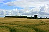
|
| [3] | 225 | 44 | ST875316 | TuMP | Long Knoll | Cranborne Chase & West Wiltshire Downs | 
| |
| Sidbury Hill[3] | 223 | 69 | SU216506 | TuMP | Walbury Hill | Salisbury Plain | Trig point, fort and earthworks | 
|
| [3] | 216 | 30 | SU074764 | TuMP | Walbury Hill | North Wessex Downs | Mast near summit | 
|
| [3] | 216 | 32 | ST909289 | TuMP | Long Knoll | North Wessex Downs | ||
| [3] | 216 | 89 | SU040555 | TuMP | Long Knoll | North Wessex Downs | Flagpole on mound summit (mound probably manmade). Ground 100m SW is lower than base of summit mound | 
|
| Barkers Hill[3] | 208 | 59 | ST905256 | TuMP | Win Green | Cranborne Chase & West Wiltshire Downs | No summit feature. | 
|
| [3] | 208 | 39 | ST898455 | TuMP | Win Green | Cranborne Chase & West Wiltshire Downs | Hilltop fort; above Waterloo Lines | 
|
| [3] | 205 | 101 | ST791661 | HuMP, TuMP | [4] | Summit within 2m of tower (Brown's Folly) | 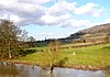
| |
| [3] | 205 | 38 | SU118614 | TuMP | Walbury Hill | North Wessex Downs | No summit feature; centre of flat area | 
|
| [3] | 204 | 88 | SU194427 | TuMP | Walbury Hill | Salisbury Plain | Above Bulford Camp and just N of A303; mast near summit. | |
| [3] | 202 | 50 | ST941268 | TuMP | Win Green | Cranborne Chase & West Wiltshire Downs | Near Old Wardour Castle | 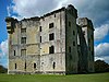
|
| Scratchbury Hill[3] | 197 | 60 | ST911442 | TuMP | Long Knoll | Salisbury Plain | Hillfort summit: Scratchbury Camp; trig point | 
|
| Castle Ditches[3] | 193 | 68 | ST962284 | TuMP | Win Green | Cranborne Chase & West Wiltshire Downs | Hillfort summit; trig point | 
|
| Silbury Hill[3] | 187 | 29 | SU100685 | Unclassified | Walbury Hill | North Wessex Downs | Prehistoric chalk mound | 
|
| Old Sarum[3] | 122 | 43 | SU138326 | TuMP | Walbury Hill | Salisbury Plain | Earliest settlement at Salisbury and remains of Iron Age hillfort, Norman castle and Old Sarum Cathedral | 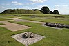
|

See also[]
- List of mountains and hills of the United Kingdom
- List of Marilyns in England
References and footnotes[]
- ^ Dawson, Alan (1992). The Relative Hills of Britain. Milnthorpe: Cicerone Press. ISBN 1-85284-068-4. Archived from the original on 2010-09-21.
- ^ Jackson, Mark. "More Relative Hills of Britain" (PDF). Relative Hills of Britain. Archived from the original (PDF) on 12 October 2013. Retrieved 31 March 2013.
- ^ Jump up to: a b c d e f g h i j k l m n o p q r s t u v w x y z aa ab ac ad ae af ag ah ai aj ak al am an ao ap aq ar as at Name, height, prominence, grid and class data from: Database of British and Irish Hills, retrieved 2 Jul 2016.
- ^ Jump up to: a b c d e Name, height, prominence, grid, class and parent data from: Jackson, Mark (2009). More Relative Hills of Britain, Marilyn News Centre, UK, p. 168. E-book Archived 2013-10-12 at the Wayback Machine.
| hide Lists of hills of Southern England | ||
|---|---|---|
 | ||
| ||
- Hills of Wiltshire
- Wiltshire-related lists
- Lists of mountains and hills of England