| Name
|
Address
|
Coordinates
|
IDF
|
IDP
|
IDM
|

|
Image
|
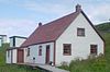
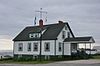
| L'Anse Amour National Historic Site of Canada
|
On the road to Point Amour, L'Anse-Amour, NL
|
 51°28′49″N 56°51′59″W / 51.4804°N 56.8663°W / 51.4804; -56.8663 (L'Anse Amour National Historic Site of Canada) 51°28′49″N 56°51′59″W / 51.4804°N 56.8663°W / 51.4804; -56.8663 (L'Anse Amour National Historic Site of Canada)
|
14130
|
|
|
|

|
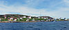
| Battle Harbour Historic District National Historic Site of Canada
|
, Battle Harbour, NL
|
52°16′26″N 55°35′07″W / 52.274°N 55.5854°W / 52.274; -55.5854 (Battle Harbour Historic District National Historic Site of Canada)
|
3453
|
|
|
|
|
| Building 1081
|
CFB Goose Bay, Happy Valley-Goose Bay, NL
|
53°17′42″N 60°22′34″W / 53.2951°N 60.3762°W / 53.2951; -60.3762 (Building 1081)
|
10648
|
|
|
|

|
| Building 1082
|
CFB Goose Bay, Happy Valley-Goose Bay, NL
|
53°17′43″N 60°22′34″W / 53.2952°N 60.3761°W / 53.2952; -60.3761 (Building 1082)
|
10651
|
|
|
|
|
| Building 1090
|
CFB Goose Bay, Happy Valley-Goose Bay, NL
|
53°17′42″N 60°22′34″W / 53.2950°N 60.3761°W / 53.2950; -60.3761 (Building 1090)
|
10709
|
|
|
|
|
| Bunkhouse/Cookhouse Registered Heritage Structure
|
, Battle Harbour, NL
|
52°15′38″N 55°36′00″W / 52.2606°N 55.6°W / 52.2606; -55.6 (Bunkhouse/Cookhouse Registered Heritage Structure)
|
|
10844
|
|
|
|
| Flour Store Registered Historic Structure
|
, Battle Harbour, NL
|
52°16′28″N 55°35′10″W / 52.2745°N 55.5860°W / 52.2745; -55.5860 (Flour Store Registered Historic Structure)
|
|
19764
|
|
|
|
| Grenfell Cottage Registered Heritage Structure
|
, Battle Harbour, NL
|
52°15′39″N 55°36′00″W / 52.2608°N 55.6°W / 52.2608; -55.6 (Grenfell Cottage Registered Heritage Structure)
|
|
10846
|
|
|

|
| Grenfell Shed and Wharf Municipal Heritage Site
|
, Mary's Harbour, NL
|
52°18′42″N 55°50′16″W / 52.3117°N 55.8378°W / 52.3117; -55.8378 (Grenfell Shed and Wharf Municipal Heritage Site)
|
|
|
5747
|
|

|
| Hebron Mission National Historic Site of Canada
|
, Hebron, NL
|
58°11′56″N 62°37′38″W / 58.199°N 62.6273°W / 58.199; -62.6273 (Hebron Mission National Historic Site of Canada)
|
9620
|
|
|
|
|
| Herring Store Registered Historic Structure
|
, Battle Harbour, NL
|
52°16′29″N 55°35′08″W / 52.2746°N 55.5856°W / 52.2746; -55.5856 (Herring Store Registered Historic Structure)
|
|
19765
|
|
|
|
| Hopedale Mission National Historic Site of Canada
|
, Hopedale, NL
|
55°27′28″N 60°12′44″W / 55.4579°N 60.2121°W / 55.4579; -60.2121 (Hopedale Mission National Historic Site of Canada)
|
11597
|
19225
|
|
|
|
| Hudson's Bay Company Net Loft
|
, Rigolet, NL
|
54°11′00″N 58°26′00″W / 54.1833°N 58.4333°W / 54.1833; -58.4333 (Hudson's Bay Company Net Loft)
|
|
2235
|
|
|

|
| Louie A. Hall
|
, Forteau, NL
|
51°28′22″N 56°57′17″W / 51.4729°N 56.9546°W / 51.4729; -56.9546 (Louie A. Hall)
|
|
2193
|
|
|
|
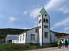
| Moravian Church Registered Heritage Structure
|
, Nain, NL
|
56°32′46″N 61°41′32″W / 56.5462°N 61.6923°W / 56.5462; -61.6923 (Moravian Church Registered Heritage Structure)
|
|
15662
|
|
|
|
| Okak National Historic Site of Canada
|
, Okak, NL
|
57°33′53″N 61°58′51″W / 57.5648°N 61.9809°W / 57.5648; -61.9809 (Okak National Historic Site of Canada)
|
14408
|
|
|
|
|
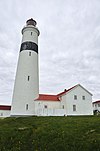
| Point Amour Lighthouse
|
, L'Anse Amour, NL
|
51°27′40″N 56°51′29″W / 51.4610°N 56.858°W / 51.4610; -56.858 (Point Amour Lighthouse)
|
20377
|
14863
|
|
|
|
| Pork Store Registered Historic Structure
|
, Battle Harbour, NL
|
52°16′27″N 55°35′07″W / 52.2741°N 55.5852°W / 52.2741; -55.5852 (Pork Store Registered Historic Structure)
|
|
19768
|
|
|
|
| Pye House
|
, Cape St. Charles, NL
|
52°13′00″N 55°38′00″W / 52.2167°N 55.6333°W / 52.2167; -55.6333 (Pye House)
|
|
2141
|
|
|
|
| Red Bay National Historic Site of Canada
|
, Red Bay, NL
|
51°44′00″N 56°25′42″W / 51.7332°N 56.4283°W / 51.7332; -56.4283 (Red Bay National Historic Site of Canada)
|
14409
|
|
|
|

|
| Royal Canadian Air Force Hangar 7
|
CFB Goose Bay, Happy Valley-Goose Bay, NL
|
53°17′53″N 60°21′09″W / 53.298°N 60.3525°W / 53.298; -60.3525 (Royal Canadian Air Force Hangar 7)
|
10870
|
|
|
|
|
| Royal Canadian Air Force Hangar 8
|
CFB Goose Bay, Happy Valley-Goose Bay, NL
|
53°17′53″N 60°21′10″W / 53.298°N 60.3527°W / 53.298; -60.3527 (Royal Canadian Air Force Hangar 8)
|
10795
|
|
|
|
|
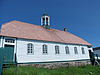
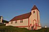
| St. James Anglican Church
|
, Battle Harbour, NL
|
52°15′39″N 55°36′00″W / 52.2607°N 55.6°W / 52.2607; -55.6 (St. James Anglican Church)
|
|
2137
|
|
|
|
| Salmon Store Registered Historic Structure
|
, Battle Harbour, NL
|
52°16′28″N 55°35′10″W / 52.2744°N 55.5862°W / 52.2744; -55.5862 (Salmon Store Registered Historic Structure)
|
|
19766
|
|
|
|
| Salt Store Registered Historic Structure
|
, Battle Harbour, NL
|
52°16′26″N 55°35′09″W / 52.2739°N 55.5858°W / 52.2739; -55.5858 (Salt Store Registered Historic Structure)
|
|
19767
|
|
|
|
| Seal Store Registered Historic Structure
|
, Battle Harbour, NL
|
52°16′27″N 55°35′08″W / 52.2741°N 55.5856°W / 52.2741; -55.5856 (Seal Store Registered Historic Structure)
|
|
19769
|
|
|
|
| Isaac Smith House Registered Heritage Structure
|
, Battle Harbour, NL
|
52°15′39″N 55°36′36″W / 52.2607°N 55.61°W / 52.2607; -55.61 (Isaac Smith House Registered Heritage Structure)
|
|
10845
|
|
|
|
| White Elephant Building Registered Heritage Structure
|
, Makkovik, NL
|
55°05′28″N 59°10′29″W / 55.0911°N 59.1746°W / 55.0911; -59.1746 (White Elephant Building Registered Heritage Structure)
|
|
2146
|
|
|
|
| Richard (Dick) White's Trading Post
|
Kauk Bight, Nain, NL
|
56°43′00″N 61°44′00″W / 56.7167°N 61.7333°W / 56.7167; -61.7333 (Richard (Dick) White's Trading Post)
|
|
2277
|
|
|
|


