List of lighthouses in Alaska

From Wikipedia, the free encyclopedia
Map all coordinates using: OpenStreetMap 
Download coordinates as: KML

This is a list of all lighthouses in the U.S. state of Alaska as identified by the United States Coast Guard. There are eleven active lights in the state; the other five have been replaced by automated skeleton towers.

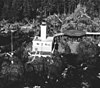
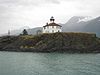
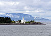
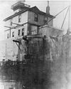
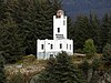
The history of Alaskan lighthouses predates the Seward purchase: the Russians erected a light at Sitka, in Baranof Castle (located on Castle Hill); this light was found unnecessary by the Lighthouse Service and discontinued, but was taken over by the army and maintained by them until 1877.[1] The first American lighthouses in the state were erected in 1902[2] but most early lights were rebuilt before 1940 in a distinctive Art Deco style; the only surviving building from the earlier group is the Eldred Rock Light.[2] The last constructed were replacements for the lights on Unimak Island in 1950.[3]

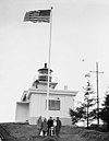
Alaska has the northernmost and westernmost lighthouses in the United States,[4] and some of the most isolated as well. Keepers at the Cape Sarichef and Scotch Cap Lights on Unimak Island in the Aleutians were not permitted to bring their families to the station, and served four years before getting an entire year of leave;[3] Cape Sarichef received no supplies from August 1912 to June 1913, and both lights shut down in the winter due to sea ice.[1] Scotch Cap was also the site of the worst lighthouse disaster in US history, when it was destroyed by a tsunami in the 1946 Aleutian Islands earthquake, killing all five coastguardmen stationed there.[2]

If not otherwise noted, focal height and coordinates are taken from the United States Coast Guard Light List,[5] while location and dates of activation, automation, and deactivation are taken from the United States Coast Guard Historical information site for lighthouses.[3]

Name Image Location Coordinates Year first lit Automated Year deactivated Current Lens Focal Height
Cape Decision Light USCGCape Decision.jpg 56°00′05″N 134°08′13″W / 56.0014°N 134.1369°W / 56.0014; -134.1369 (Cape Decision Light) 1932 1974 Active DCB-24 096 96 ft (29 m)
Cape Hinchinbrook Light USCGCape Hinchinbrook.jpg 60°14′15″N 146°38′47″W / 60.2374°N 146.6465°W / 60.2374; -146.6465 (Cape Hinchinbrook Light) 1910 (First)
1934 (Current)
1974 Active VRB-25 235 235 ft (72 m)
Cape Sarichef Light USCGcapesarichef.JPG 54°35′54″N 164°55′39″W / 54.5982°N 164.9276°W / 54.5982; -164.9276 (Cape Sarichef Light) 1904 (First)
1950 (Last)
1979 1979
(Demolished in 1999)
None 177 177 ft (54 m)[6]
Cape Spencer Light USCGcapespencer.JPG 58°11′56″N 136°38′26″W / 58.1988°N 136.6405°W / 58.1988; -136.6405 (Cape Spencer Light) 1925 1974 Active Un­known 105 105 ft (32 m)
Cape St. Elias Light Cape Stelias light.jpg 59°47′54″N 144°35′56″W / 59.7984°N 144.5988°W / 59.7984; -144.5988 (Cape St. Elias Light) 1916 1974 Active VRB-25 085 85 ft (26 m)
Eldred Rock Light Eldred Rock Lighthouse - Alaska.jpg 58°58′15″N 135°13′15″W / 58.9709°N 135.2209°W / 58.9709; -135.2209 (Eldred Rock Light) 1906 1973 Active 250mm 091 91 ft (28 m)
Fairway Island Light 57°26′34″N 134°52′18″W / 57.4428°N 134.8718°W / 57.4428; -134.8718 (Fairway Island Light) 1904 Never Unknown
(Est: 1917-1925)
None 041 41 ft (12 m)
Five Finger Islands Light Five Finger Light House 49.jpg 57°16′13″N 133°37′53″W / 57.2704°N 133.6315°W / 57.2704; -133.6315 (Five Finger Islands Light) 1902 (First)
1935 (Current)
1984 Active Un­known 081 81 ft (25 m)
Guard Island Light USCGguardisland1924.JPG 55°26′45″N 131°52′52″W / 55.4459°N 131.8811°W / 55.4459; -131.8811 (Guard Island Light) 1904 (First)
1924 (Current)
1969 Active Un­known 074 74 ft (23 m)
Lincoln Rock Light USCGlincolnrocks.JPG 56°03′25″N 132°41′49″W / 56.057°N 132.697°W / 56.057; -132.697 (Lincoln Rock Light) 1903 (First)
1944 (Last)
Never 1968
(Demolished)
None 058 58 ft (18 m)
Mary Island Light Maryisland1937.jpg 55°05′56″N 131°10′57″W / 55.0990°N 131.1826°W / 55.0990; -131.1826 (Mary Island Light) 1903 (First)
1937 (Current)
1969 Active 250mm 076 76 ft (23 m)
Point Retreat Light Pt Retreat L 1143.jpg 58°24′41″N 134°57′18″W / 58.4115°N 134.9551°W / 58.4115; -134.9551 (Point Retreat Light) 1904 (First)
1923 (Current)
1973 Active 300mm 063 63 ft (19 m)
Point Sherman Light USCGpointsherman.JPG 58°51′11″N 135°09′06″W / 58.8531°N 135.1517°W / 58.8531; -135.1517 (Point Sherman Light) 1904 (First)
1981 (Current)
1911 Active Un­known 020 20 ft (6.1 m)
Scotch Cap Light USCGscotchcap1950.JPG 54°23′45″N 164°44′43″W / 54.3958°N 164.7453°W / 54.3958; -164.7453 (Scotch Cap Light) 1903 (First)
1950 (Last)
1971 1977[7] None 116 116 ft (35 m)[6]
Sentinel Island Light Sentinel Lighthouse 48.jpg 58°32′46″N 134°55′22″W / 58.5460°N 134.9229°W / 58.5460; -134.9229 (Sentinel Island Light) 1902 (First)
1935 (Current)
1966 Active Un­known 086 86 ft (26 m)
Tree Point Light USCGtreepoint1935.JPG 54°48′10″N 130°56′02″W / 54.8029°N 130.9338°W / 54.8029; -130.9338 (Tree Point Light) 1904 (First)
1935 (Current)
1969 Active VRB-25 086 86 ft (26 m)

References[]

  1. ^ a b Noble, Dennis (1999). "Alaska and Hawaii: A Brief History of U.S. Coast Guard Operations" (PDF). Retrieved 2007-07-05.
  2. ^ a b c Rowlett, Russ. "Lighthouses of Alaska". The Lighthouse Directory. University of North Carolina at Chapel Hill.
  3. ^ a b c "Historic Light Station Information and Photography: Alaska" (PDF). United States Coast Guard Historian's Office.
  4. ^ de Wire, Elinor (2007). The Lightkeepers' Managerie: Stories of Animals at Lighthouses. Sarasota, Florida: Pineapple Press. ISBN 9781561643912.
  5. ^ Light List, Volume VI, Pacific Coast and Pacific Islands (PDF). Light List. United States Coast Guard. 2012.
  6. ^ a b Willapa Bay (Map). 1:300,000. US Department of Commerce. 1968. Chart 8860.
  7. ^ Bering Sea:Eastern Part (Map). 1:1,534,076. NOAA. 1978. Chart 16006. This is the first chart catalogued which shows the shorter skeleton tower.
Retrieved from ""