List of listed buildings in Bonhill, West Dunbartonshire
This is a list of listed buildings in the southern part of the parish of Bonhill, in West Dunbartonshire, Scotland. The northern part of Bonhill parish is within Argyll and Bute. See List of listed buildings in Bonhill, Argyll and Bute.
List[]
| Name | Location | Date Listed | Grid Ref. [note 1] | Geo-coordinates | Notes | LB Number [note 2] | Image |
|---|---|---|---|---|---|---|---|
| Balloch Castle, Walled Garden | 56°00′32″N 4°34′57″W / 56.008914°N 4.582409°W | Category B | 43222 | 
| |||
| Jamestown Primary School With Boundary Wall And Railings | 55°59′54″N 4°34′14″W / 55.99845°N 4.570451°W | Category C(S) | 43226 | 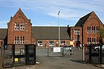
| |||
| Lower Stoneymullen Road, Drumkinnon Farm | 55°59′59″N 4°35′51″W / 55.99979°N 4.597422°W | Category B | 4903 |
| |||
| Bonhill Parish Church With Boundary Wall And Graveyard | 55°58′58″N 4°34′27″W / 55.982677°N 4.574294°W | Category B | 1095 | 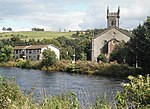
| |||
| Westerton House With Gatepiers And Walled Garden | 56°01′05″N 4°32′52″W / 56.017939°N 4.547805°W | Category B | 1127 |
| |||
| Jamestown Parish Church Of Scotland With Boundary Wall Railings And Gatepiers | 55°59′53″N 4°34′15″W / 55.998163°N 4.570833°W | Category B | 1137 | 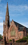
| |||
| Balloch Castle | 56°00′47″N 4°35′01″W / 56.01303°N 4.583694°W | Category A | 123 | 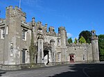
| |||
| Alexandria, North Main Street, Argyll Motor Works With Lodge, Gatepiers, Railings And Boundary Wall | 55°59′31″N 4°35′02″W / 55.991924°N 4.583825°W | Category A | 127 | 
| |||
| Alexandria, Bank Street, Vale Of Leven Constitutional Club | 55°59′11″N 4°34′40″W / 55.986487°N 4.57777°W | Category C(S) | 43194 | 
| |||
| Alexandria, 252 Main Street | 55°59′07″N 4°34′53″W / 55.985144°N 4.581368°W | Category C(S) | 43201 |
| |||
| Alexandria, Queen's Drive, Saint Mungo's Episcopal Church With Hall, Boundary Wall And Gatepiers | 55°58′54″N 4°35′01″W / 55.981772°N 4.583596°W | Category B | 43210 |
| |||
| Balloch, Drymen Road, Tullichewan Hotel | 56°00′10″N 4°35′00″W / 56.002747°N 4.583313°W | Category C(S) | 43217 |
| |||
| Balloch, Lomond Road, Bridge | 56°00′06″N 4°34′52″W / 56.00159°N 4.581054°W | Category B | 43218 |
| |||
| Balloch, Lomond Road, Fisherwood | 56°00′04″N 4°34′55″W / 56.001043°N 4.581867°W | Category B | 43219 | 
| |||
| Alexandria, Christie Park, War Memorial | 55°59′25″N 4°35′06″W / 55.990266°N 4.584869°W | Category B | 43197 | 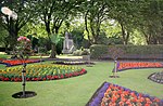
| |||
| Alexandria, Overton Road, Vale Of Leven Cemetery With Monuments, Bridge, Boundary Wall, Gates And Gatepiers | 55°59′03″N 4°35′29″W / 55.984042°N 4.591476°W | Category B | 43206 |
| |||
| Balloch, Balloch Road Bridge | 56°00′12″N 4°34′55″W / 56.003389°N 4.581848°W | Category B | 43215 |
| |||
| Cameron House, Mid Lodge With Boundary Wall, Gatepiers, Gates And Railings | 56°00′48″N 4°36′40″W / 56.013467°N 4.611161°W | Category B | 1122 |
| |||
| Alexandria, Gilmour Street, Masonic Temple | 55°59′13″N 4°35′07″W / 55.987033°N 4.585166°W | Category A | 1135 | 
| |||
| Alexandria, Main Street, Saint Andrew's Parish Church With Gatepiers, Railings, Graveyard And Smollett Mausoleum | 55°59′08″N 4°34′47″W / 55.98551°N 4.579757°W | Category B | 1136 |
| |||
| Alexandria, Glen Alwyn Lodge With Gatepiers And Wall | 56°00′05″N 4°35′31″W / 56.001265°N 4.591827°W | Category B | 91 |
| |||
| Alexandria, Albert Street, Methodist Church With Gatepiers And Railings | 55°59′01″N 4°34′50″W / 55.983671°N 4.580485°W | Category C(S) | 43191 |
| |||
| Alexandria, Bank Street, Post Office With Gatepiers And Boundary Wall | 55°59′11″N 4°34′39″W / 55.986438°N 4.577542°W | Category C(S) | 43192 |
| |||
| Alexandria, 304 Main Street, Ardenlee With Boundary Wall And Gatepiers | 55°59′02″N 4°34′54″W / 55.983851°N 4.581747°W | Category C(S) | 43198 |
| |||
| Alexandria, Overton Road, Kirkland With Boundary Wall And Gatepiers | 55°59′08″N 4°35′08″W / 55.985559°N 4.585597°W | Category C(S) | 43205 |
| |||
| Balloch Castle, North Lodge With Gatepiers And Boundary Wall | 56°00′48″N 4°34′31″W / 56.013412°N 4.57536°W | Category C(S) | 43220 |
| |||
| Alexandria, Gilmour Street, Ewing Gilmour Institute | 55°59′14″N 4°34′58″W / 55.987209°N 4.582789°W | Category B | 1096 | 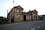
| |||
| Cameron House With Terrace Walls | 56°00′48″N 4°36′29″W / 56.013397°N 4.608124°W | Category B | 1121 | 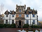
| |||
| Alexandria, Christie Park With Lodge, Gates, Gatepiers And Boundary Wall | 55°59′23″N 4°35′02″W / 55.989605°N 4.583799°W | Category B | 43196 |
| |||
| Alexandria, 354 Main Street, With Boundary Wall | 55°58′56″N 4°34′59″W / 55.982233°N 4.583034°W | Category C(S) | 43202 |
| |||
| Alexandria, North Main Street, Bellville With Boundary Wall | 55°59′25″N 4°35′01″W / 55.990318°N 4.583654°W | Category B | 43203 |
| |||
| Alexandria, North Main Street, Lodge With Boundary Walls, Gates And Gatepiers | 55°59′27″N 4°35′04″W / 55.990831°N 4.584506°W | Category B | 43204 |
| |||
| Alexandria, Middleton Street, Christie Park Primary School With Gatepiers And Boundary Wall And Railings | 55°59′19″N 4°35′08″W / 55.988651°N 4.585595°W | Category C(S) | 6610 |
| |||
| Alexandria, Smollett Fountain With Lamp Standards | 55°59′16″N 4°34′56″W / 55.987798°N 4.582123°W | Category B | 1134 | 
| |||
| Loch Lomond, Drumkinnon Bay, Winch House Including Slipway | 56°00′28″N 4°35′27″W / 56.007782°N 4.590964°W | Category A | 46721 | 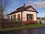
| |||
| Bonhill, 120-122 (Even Nos), Main Street And Adjoining Workshop | 55°59′08″N 4°34′22″W / 55.985549°N 4.572769°W | Category B | 43224 |
| |||
| Lower Stoneymollen Road, Drumkinnon Farm, Mill, Granary And Saw Mill | 55°59′58″N 4°35′50″W / 55.999444°N 4.597207°W | Category B | 43229 |
| |||
| Westerton Lodge Gatepiers And Boundary Wall | 56°00′52″N 4°33′04″W / 56.014573°N 4.551049°W | Category C(S) | 43232 | 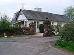
| |||
| Alexandria, 320 Main Street, Niagra With Boundary Walls | 55°59′00″N 4°34′56″W / 55.983331°N 4.582097°W | Category C(S) | 43199 |
| |||
| Alexandria, Upper Smollett Road, Alexandria House With Boundary Walls And Gatepiers | 55°59′05″N 4°35′08″W / 55.984589°N 4.585532°W | Category C(S) | 43212 |
| |||
| Balloch, Drymen Road, The Cottage With Gatepiers And Boundary Wall | 56°00′21″N 4°34′18″W / 56.005807°N 4.571534°W | Category C(S) | 43216 |
| |||
| Woodbank House With Garden Building | 56°00′05″N 4°35′47″W / 56.001384°N 4.596407°W | Category A | 1125 | 
| |||
| Balloch Castle, South Lodge With Boundary Walls And Gatepiers | 56°00′17″N 4°34′36″W / 56.004618°N 4.576796°W | Category B | 43221 |
| |||
| Bonhill, Jamestown Road, Dalmonach Print And Dye Works, Lodge | 55°59′21″N 4°34′21″W / 55.989255°N 4.572615°W | Category C(S) | 43223 |
| |||
| Tullichewan Estate, Stables Cottage | 55°59′43″N 4°35′46″W / 55.995155°N 4.596005°W | Category B | 43230 |
| |||
| Cameron House, South Lodge With Gatepiers And Boundary Wall | 56°00′16″N 4°35′55″W / 56.004332°N 4.598577°W | Category B | 4904 |
| |||
| Alexandria, Bank Street, Vale Of Leven Bingo Club With Boundary Wall, Railings And Portals | 55°59′06″N 4°34′29″W / 55.98502°N 4.574835°W | Category B | 43193 |
| |||
| Alexandria, 127-133, Main Street, Bank Of Scotland | 55°59′13″N 4°34′53″W / 55.987059°N 4.581336°W | Category C(S) | 43200 |
| |||
| Drumkinnon Cottage With Wall And Railings | 56°00′16″N 4°35′51″W / 56.004327°N 4.597502°W | Category C(S) | 1124 |
|

Key[]
The scheme for classifying buildings in Scotland is:
- Category A: "buildings of national or international importance, either architectural or historic; or fine, little-altered examples of some particular period, style or building type."[1]
- Category B: "buildings of regional or more than local importance; or major examples of some particular period, style or building type, which may have been altered."[1]
- Category C: "buildings of local importance; lesser examples of any period, style, or building type, as originally constructed or moderately altered; and simple traditional buildings which group well with other listed buildings."[1]
In March 2016 there were 47,288 listed buildings in Scotland. Of these, 8% were Category A, and 50% were Category B, with the remaining 42% being Category C.[2]
Notes[]
- ^ Sometimes known as OSGB36, the grid reference (where provided) is based on the British national grid reference system used by the Ordnance Survey.
• "Guide to National Grid". Ordnance Survey. Retrieved 12 December 2007.
• "Get-a-map". Ordnance Survey. Retrieved 17 December 2007. - ^ Historic Environment Scotland assign a unique alphanumeric identifier to each designated site in Scotland, for listed buildings this always begins with "LB", for example "LB12345".
References[]
- All entries, addresses and coordinates are based on data from Historic Scotland. This data falls under the Open Government Licence
- ^ a b c "What is Listing?". Historic Environment Scotland. Retrieved 29 May 2018.
- ^ Scotland's Historic Environment Audit 2016 (PDF). Historic Environment Scotland and the Built Environment Forum Scotland. pp. 15–16. Retrieved 29 May 2018.
Categories:
- Lists of listed buildings in West Dunbartonshire
- Vale of Leven