List of listed buildings in Ceres, Fife
This is a list of listed buildings in the parish of Ceres in Fife, Scotland.
List[]
| Name | Location | Date Listed | Grid Ref. [note 1] | Geo-coordinates | Notes | LB Number [note 2] | Image |
|---|---|---|---|---|---|---|---|
| Bridge Over Ceres Burn, South Of Pitscottie | 56°18′05″N 2°56′46″W / 56.301497°N 2.94605°W | Category B | 6501 | 
| |||
| Ceres, Saughtree, Main Street, House, Store And Garages | 56°17′40″N 2°58′34″W / 56.294399°N 2.976072°W | Category C(S) | 4286 |
| |||
| High Street, House And Shop ( James Walker) | 56°17′32″N 2°58′14″W / 56.292277°N 2.970638°W | Category C(S) | 4292 |
| |||
| High Street, Kirphon | 56°17′32″N 2°58′14″W / 56.292115°N 2.97065°W | Category C(S) | 4294 |
| |||
| Teassesmill Bridge | 56°17′08″N 2°58′19″W / 56.285519°N 2.972018°W | Category B | 2424 |
| |||
| Dairy, Castlegate, Ceres | 56°17′30″N 2°58′12″W / 56.291796°N 2.970125°W | Category C(S) | 2371 |
| |||
| Castlegate Farmhouse Castlegate, Ceres | 56°17′30″N 2°58′12″W / 56.291797°N 2.969947°W | Category C(S) | 2372 |
| |||
| 15 Main Street, Plumtree Cottage | 56°17′34″N 2°58′15″W / 56.292896°N 2.970718°W | Category B | 2383 |
| |||
| Cottage At East Gate, Baltilly, Formerly Occupied By James Archibald | 56°17′36″N 2°58′29″W / 56.293234°N 2.974653°W | Category C(S) | 2386 |
| |||
| Southern Outbuilding Of Brand's Hotel, High Street, Ceres | 56°17′31″N 2°58′14″W / 56.291944°N 2.970678°W | Category A | 2393 | 
| |||
| Castle House, Anstruther Road, Ceres | 56°17′32″N 2°58′04″W / 56.292191°N 2.967792°W | Category C(S) | 2397 |
| |||
| Cummerfield Cottage, Anstruther Road, Ceres | 56°17′32″N 2°58′04″W / 56.292092°N 2.967838°W | Category C(S) | 2398 |
| |||
| Ceres, Kirklands, 43 Main Street | 56°17′39″N 2°58′24″W / 56.294079°N 2.973382°W | Category C(S) | 4285 |
| |||
| Bridgend, Dam Bridge | 56°17′41″N 2°58′35″W / 56.294648°N 2.97645°W | Category B | 4295 |
| |||
| Bridgend, Gatepiers To Eastmost House On S Side Of New Town, West Of Bridge | 56°17′41″N 2°58′37″W / 56.294726°N 2.976824°W | Category C(S) | 4296 |
| |||
| Scotstarvit Tower | 56°17′23″N 3°01′08″W / 56.28967°N 3.018828°W | Category A | 2416 |
| |||
| Craigrothie, Footbridge | 56°17′21″N 3°00′01″W / 56.289194°N 3.000156°W | Category B | 2419 |
| |||
| Kilhill Bridge Over Ceres Burn | 56°17′57″N 2°57′35″W / 56.299119°N 2.959629°W | Category C(S) | 2427 |
| |||
| Struthers Doocot | 56°16′33″N 3°00′27″W / 56.275739°N 3.007395°W | Category B | 2431 |
| |||
| Loch Houses | 56°17′29″N 2°58′25″W / 56.291338°N 2.973506°W | Category C(S) | 2442 |
| |||
| Baltilly, House And Walled Garden With Sundial | 56°17′35″N 2°58′32″W / 56.293047°N 2.975521°W | Category B | 2384 |
| |||
| Viewfield Cottage St Andrew's Road Including Garden Walls And Gatepiers | 56°17′37″N 2°58′02″W / 56.293668°N 2.967329°W | Category B | 2391 |
| |||
| Fife Folk Museum (Central And North Fife Preservation Society) High Street, Ceres[1] | 56°17′31″N 2°58′14″W / 56.291847°N 2.970466°W[1]) | Category A | 2394 | ![Fife Folk Museum (Central And North Fife Preservation Society) High Street, Ceres[1]](http://upload.wikimedia.org/wikipedia/commons/thumb/3/33/Fife_Folk_Museum%2C_Ceres_%28geograph_5493633%29.jpg/150px-Fife_Folk_Museum%2C_Ceres_%28geograph_5493633%29.jpg)
| |||
| Old Manse, Anstruther Road, Ceres | 56°17′29″N 2°58′01″W / 56.29147°N 2.96695°W | Category B | 2403 |
| |||
| Smithy Cottage And Smith, Schoolhill, Junction With Anstruther Road | 56°17′33″N 2°58′04″W / 56.292488°N 2.967784°W | Category C(S) | 2405 |
| |||
| Restalrig And Marlowes, Schoolhill, Ceres | 56°17′33″N 2°58′02″W / 56.292555°N 2.967204°W | Category C(S) | 2407 |
| |||
| Craighall Den, Ceres, Limekiln | 56°17′03″N 2°57′25″W / 56.284225°N 2.957011°W | Category B | 51767 |
| |||
| Greenside Farm Steading | 56°15′17″N 2°58′52″W / 56.2548°N 2.981068°W | Category A | 4302 | 
| |||
| Teasses Estate, Walled Garden | 56°15′42″N 2°57′11″W / 56.261766°N 2.953092°W | Category C(S) | 3436 |
| |||
| Teasses House, Gatelodge | 56°15′35″N 2°57′56″W / 56.259648°N 2.965566°W | Category B | 3437 |
| |||
| Bow Butts Bridge - Bannockburn Monument | 56°17′31″N 2°58′17″W / 56.292064°N 2.971424°W | Category C(S) | 2409 |
| |||
| House (Jasmine S Mair) South Croftdyke, Ceres | 56°17′29″N 2°58′19″W / 56.291468°N 2.971862°W | Category C(S) | 2412 |
| |||
| Bridge Over Ceres Burn, On B939, West Side Pitscottie | 56°18′20″N 2°56′47″W / 56.305672°N 2.946347°W | Category C(S) | 2428 |
| |||
| Wood End Cottage, North Croftdyke, Ceres | 56°17′33″N 2°58′23″W / 56.292527°N 2.973052°W | Category C(S) | 2441 |
| |||
| Edenwood Home Farm (Front Nw Part Only) | 56°17′40″N 3°02′10″W / 56.294307°N 3.036062°W | Category B | 2444 |
| |||
| Crawford Priory East Gate Gate Piers On A92 Near Clushford Toll | 56°17′28″N 3°02′33″W / 56.290974°N 3.042483°W | Category C(S) | 2446 |
| |||
| Kirk Brae Lindsay Vault, Parish Churchyard (Formerly Main Street), Ceres | 56°17′37″N 2°58′18″W / 56.293662°N 2.97161°W | Category B | 2365 | 
| |||
| St John's Masonic Lodge Off High Street, Ceres, Including Garden Walls | 56°17′29″N 2°58′13″W / 56.291407°N 2.970406°W | Category A | 2368 | 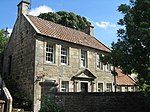
| |||
| Kimberley (Former Parish School) 33 Main Street, Ceres Including Garden Walls | 56°17′37″N 2°58′21″W / 56.293602°N 2.972384°W | Category B | 2380 |
| |||
| 1 Main Street, The Cross, Corner St Andrew's Road (Mrs Cunningham) | 56°17′33″N 2°58′13″W / 56.292567°N 2.970274°W | Category C(S) | 2382 |
| |||
| Cottage (A Macdonald), Baltilly | 56°17′36″N 2°58′28″W / 56.293387°N 2.974576°W | Category C(S) | 2387 |
| |||
| Castle Bank, Anstruther Road, Ceres | 56°17′32″N 2°58′04″W / 56.292281°N 2.967779°W | Category C(S) | 2396 |
| |||
| High Street, Burnview | 56°17′32″N 2°58′14″W / 56.292196°N 2.970668°W | Category B | 4293 |
| |||
| Craigrothie House, Icehouse And Screen Wall Linked To House | 56°17′18″N 3°00′02″W / 56.288364°N 3.000538°W | Category B | 4300 |
| |||
| House (John Webster, Southern House), South Croftdyke, Ceres | 56°17′29″N 2°58′18″W / 56.291297°N 2.971793°W | Category C(S) | 2414 |
| |||
| Wellwood, Well | 56°17′54″N 2°57′40″W / 56.298289°N 2.961192°W | Category B | 2425 |
| |||
| Gathercauld Bridge Over Craighall Burn | 56°16′29″N 2°56′06″W / 56.274806°N 2.935071°W | Category C(S) | 2429 |
| |||
| Teasses House | 56°15′42″N 2°57′30″W / 56.261591°N 2.958383°W | Category B | 2430 |
| |||
| Kirk Brae Ceres Parish Churchyard (Formerly Main Street), Ceres | 56°17′37″N 2°58′16″W / 56.293746°N 2.971144°W | Category C(S) | 2364 |
| |||
| Bishop Bridge Over Ceres Burn, Including Approach Walls Linking To Folk Museum, Ceres | 56°17′29″N 2°58′14″W / 56.291495°N 2.970683°W | Category A | 2366 | 
| |||
| 1 Kirk Brae Parish Church Hall (Formerly 31 Main Street), Ceres | 56°17′36″N 2°58′17″W / 56.293438°N 2.971508°W | Category B | 2379 |
| |||
| Brand's Hotel, High Street, Ceres Including North-West Wing | 56°17′31″N 2°58′15″W / 56.292052°N 2.970729°W | Category B | 2392 |
| |||
| War Memorial Hall, Anstruther Road, Ceres | 56°17′30″N 2°58′02″W / 56.291657°N 2.967197°W | Category B | 2402 |
| |||
| Main Street, Premises Formerly P Butt And Sons, Ceres | 56°17′37″N 2°58′22″W / 56.293554°N 2.972755°W | Category C(S) | 4287 |
| |||
| 56 Main Street, Meldrum's Hotel | 56°17′37″N 2°58′25″W / 56.293619°N 2.973677°W | Category C(S) | 4289 |
| |||
| Teasses Estate, Steading | 56°15′43″N 2°57′27″W / 56.261867°N 2.95755°W | Category B | 3435 |
| |||
| House (David Kidd) South Croftdyke Ceres | 56°17′30″N 2°58′19″W / 56.291566°N 2.971929°W | Category C(S) | 2411 |
| |||
| Hill Of Tarvit Dovecot | 56°17′30″N 3°00′23″W / 56.291731°N 3.006378°W | Category B | 2418 |
| |||
| Mile Plate On A92 Near Tarvit Mill | 56°18′02″N 3°01′41″W / 56.300691°N 3.027945°W | Category B | 2445 |
| |||
| Dunroamin, Bishop Bridge Off High Street, Ceres | 56°17′30″N 2°58′13″W / 56.291533°N 2.970409°W | Category C(S) | 2367 |
| |||
| Wilbra Cottage, South Croftdyke, Ceres | 56°17′28″N 2°58′19″W / 56.291073°N 2.971835°W | Category C(S) | 2375 |
| |||
| Coachhouse And Offices, Baltilly | 56°17′35″N 2°58′30″W / 56.293178°N 2.974862°W | Category C(S) | 2385 |
| |||
| St Helens, St Andrew's Road | 56°17′37″N 2°58′07″W / 56.293524°N 2.968553°W | Category B | 2390 |
| |||
| 17,19 Main Street | 56°17′35″N 2°58′15″W / 56.292994°N 2.970834°W | Category B | 4284 |
| |||
| 54 Main Street | 56°17′36″N 2°58′22″W / 56.293454°N 2.972898°W | Category C(S) | 4288 |
| |||
| Bridgend House Including Ancillary Structures, Gatepiers, Boundary Walls And Walled Garden And 1 And 2 Back Latch, Bridgend Cottage | 56°17′44″N 2°58′39″W / 56.295475°N 2.97757°W | Category B | 4299 |
| |||
| Craigrothie Mill And Detached Garage Block | 56°17′18″N 3°00′01″W / 56.288393°N 3.000265°W | Category B | 2421 |
| |||
| Kilhill House | 56°17′57″N 2°57′32″W / 56.299287°N 2.958809°W | Category C(S) | 2426 |
| |||
| 3 Kirk Brae Ceres Parish Church (Formerly Main Street) Ceres | 56°17′37″N 2°58′19″W / 56.293633°N 2.971917°W | Category B | 2363 |
| |||
| Castlegate Farm, Castlegate, Ceres | 56°17′31″N 2°58′10″W / 56.291837°N 2.969464°W | Category C(S) | 2373 |
| |||
| House And Shop (G Donaldson) Almac, Windsor House, Anstruther Road, Ceres | 56°17′33″N 2°58′08″W / 56.292515°N 2.968948°W | Category C(S) | 2374 |
| |||
| 17 Kirk Brae Mansefield (Former Manse) And Offices Curling Pond Road Off Main Street) | 56°17′40″N 2°58′21″W / 56.294382°N 2.97263°W | Category B | 2381 |
| |||
| Ceres Inn (Former Volunteer Arms) The Cross, St Andrew's Road And Main Street, Ceres | 56°17′33″N 2°58′15″W / 56.292446°N 2.970788°W | Category B | 2388 |
| |||
| Store Building Adjoining St Margaret's On East, Anstruther Road, Ceres | 56°17′33″N 2°58′07″W / 56.292455°N 2.968575°W | Category C(S) | 2395 |
| |||
| Premises (D Kitching) Anstruther Road, Ceres | 56°17′31″N 2°58′03″W / 56.291834°N 2.967557°W | Category C(S) | 2401 |
| |||
| Struthers Castle | 56°16′32″N 3°00′26″W / 56.275624°N 3.007134°W | Category B | 152 |
| |||
| St Andrew Road, The Cross, House (Beaton) | 56°17′33″N 2°58′13″W / 56.29237°N 2.970204°W | Category B | 4290 |
| |||
| Bridgend, Catherine Bank, Coach House | 56°17′43″N 2°58′38″W / 56.29529°N 2.977113°W | Category B | 4298 |
| |||
| House (John Webster, Northern House), South Croftdyke, Ceres | 56°17′29″N 2°58′19″W / 56.291387°N 2.971827°W | Category C(S) | 2413 |
| |||
| Crawford Priory The Kennels Cottage (Near Clushford Toll) | 56°17′29″N 3°02′38″W / 56.291465°N 3.043983°W | Category B | 2415 |
| |||
| Craigrothie House | 56°17′18″N 3°00′03″W / 56.288379°N 3.000927°W | Category B | 2417 |
| |||
| Craigrothie Doocot | 56°17′15″N 3°00′03″W / 56.287545°N 3.000711°W | Category B | 2420 |
| |||
| Ye Kingarrach Inn (Formerly Craigrothie Inn), Main Street, Craigrothie | 56°17′13″N 3°00′18″W / 56.286935°N 3.005057°W | Category B | 2422 |
| |||
| Craigrothie Bridge Over Craigrothie Burn | 56°17′15″N 3°00′19″W / 56.287374°N 3.005214°W | Category C(S) | 2423 |
| |||
| Struthers Farmhouse | 56°16′35″N 3°00′23″W / 56.276331°N 3.006329°W | Category C(S) | 2432 |
| |||
| Orchard Vaults And Associated Garden Walls, South Of St John's Lodge, Ceres | 56°17′27″N 2°58′14″W / 56.290823°N 2.97044°W | Category B | 2369 |
| |||
| House (J W Mitchell) North Croftdyke, Ceres | 56°17′32″N 2°58′20″W / 56.292112°N 2.97225°W | Category C(S) | 2377 |
| |||
| Cottages (Now Incorporated Into J W Mitchell's House) North Croftdyke, Ceres | 56°17′32″N 2°58′21″W / 56.292209°N 2.972381°W | Category C(S) | 2378 |
| |||
| Ceres Academy Schoolmaster's House Schoolhill, Ceres | 56°17′35″N 2°58′02″W / 56.29295°N 2.967278°W | Category B | 2406 |
| |||
| High Street, The Provost | 56°17′32″N 2°58′13″W / 56.292297°N 2.97038°W | Category B | 4291 |
| |||
| Bridgend, Catherine Bank | 56°17′44″N 2°58′37″W / 56.295606°N 2.976895°W | Category B | 4297 |
| |||
| Teassesmill House | 56°17′07″N 2°58′21″W / 56.285156°N 2.972428°W | Category B | 4301 |
| |||
| Bog Well, South Croftdyke, Ceres | 56°17′29″N 2°58′18″W / 56.291497°N 2.971555°W | Category B | 2410 |
| |||
| St Margaret's, Anstruther Road, Ceres | 56°17′33″N 2°58′08″W / 56.292489°N 2.968769°W | Category C(S) | 2433 |
| |||
| Croft House North Croftdyke, Ceres | 56°17′32″N 2°58′22″W / 56.29234°N 2.972885°W | Category C(S) | 2440 |
| |||
| Edenwood House | 56°17′43″N 3°02′31″W / 56.295327°N 3.042004°W | Category B | 2443 |
| |||
| House (Mckellar) Castlegate, Ceres | 56°17′30″N 2°58′13″W / 56.291768°N 2.97027°W | Category C(S) | 2370 |
| |||
| House (A D Mitchell) North Croftdyke, Ceres | 56°17′31″N 2°58′20″W / 56.291995°N 2.97215°W | Category C(S) | 2376 |
| |||
| St Ann's St Andrew's Road, Ceres | 56°17′34″N 2°58′11″W / 56.292842°N 2.969667°W | Category B | 2389 |
| |||
| Cottage (Mary L Borland) Anstruther Road, Ceres | 56°17′31″N 2°58′04″W / 56.292011°N 2.967869°W | Category C(S) | 2399 |
| |||
| Cottage (J P Robertson) Anstruther Road, Ceres Including Garden Wall | 56°17′31″N 2°58′04″W / 56.291885°N 2.967865°W | Category C(S) | 2400 |
| |||
| Bow Butts Bridge Over Ceres Burn Including Parapet Walls Of Approaches | 56°17′32″N 2°58′16″W / 56.292102°N 2.971151°W | Category B | 2408 |
|
Key[]
The scheme for classifying buildings in Scotland is:
- Category A: "buildings of national or international importance, either architectural or historic; or fine, little-altered examples of some particular period, style or building type."[2]
- Category B: "buildings of regional or more than local importance; or major examples of some particular period, style or building type, which may have been altered."[2]
- Category C: "buildings of local importance; lesser examples of any period, style, or building type, as originally constructed or moderately altered; and simple traditional buildings which group well with other listed buildings."[2]
In March 2016 there were 47,288 listed buildings in Scotland. Of these, 8% were Category A, and 50% were Category B, with the remaining 42% being Category C.[3]
See also[]
Notes[]
- ^ Sometimes known as OSGB36, the grid reference (where provided) is based on the British national grid reference system used by the Ordnance Survey.
• "Guide to National Grid". Ordnance Survey. Retrieved 2007-12-12.
• "Get-a-map". Ordnance Survey. Retrieved 2007-12-17. - ^ Historic Environment Scotland assign a unique alphanumeric identifier to each designated site in Scotland, for listed buildings this always begins with "LB", for example "LB12345".
References[]
- All entries, addresses and coordinates are based on data from Historic Scotland. This data falls under the Open Government Licence
- ^ "Home". Fife Folk Museum.
- ^ a b c "What is Listing?". Historic Environment Scotland. Retrieved 29 May 2018.
- ^ Scotland's Historic Environment Audit 2016 (PDF). Historic Environment Scotland and the Built Environment Forum Scotland. pp. 15–16. Retrieved 29 May 2018.
Categories:
- Lists of listed buildings in Fife