List of listed buildings in Grangemouth, Falkirk
This is a list of listed buildings in the parish of Grangemouth in Falkirk, Scotland.
List[]
| Name | Location | Date Listed | Grid Ref. [note 1] | Geo-coordinates | Notes | LB Number [note 2] | Image |
|---|---|---|---|---|---|---|---|
| Sacred Heart Rc Church Dalratho Road And Drummond Place | 56°00′58″N 3°43′05″W / 56.016082°N 3.718031°W | Category C(S) | 34040 | 
| |||
| Dundas Church Bo'Ness Road | 56°01′08″N 3°43′10″W / 56.018829°N 3.719484°W | Category A | 34041 |
| |||
| Avondale House | 55°59′41″N 3°40′39″W / 55.994679°N 3.677381°W | Category B | 8306 |
| |||
| Grangemouth Dock, Former Workshop Building | 56°01′27″N 3°43′29″W / 56.024105°N 3.724597°W | Category C(S) | 50868 |
| |||
| West Lodge Gatepiers | 55°59′30″N 3°43′33″W / 55.991621°N 3.725763°W | Category B | 8303 |
| |||
| Carron House | 56°01′36″N 3°46′14″W / 56.02677°N 3.770499°W | Category B | 8313 |
| |||
| Brightons, Main Street, Brightons Parish Church Including Boundary Wall, Railings, Gatepiers And Gates | 55°58′53″N 3°43′08″W / 55.981338°N 3.718894°W | Category C(S) | 50051 | 
| |||
| Bo'Ness Road, Avon Hall And Gatepiers | 56°00′55″N 3°42′25″W / 56.015256°N 3.706957°W | Category B | 34042 |
| |||
| Ronaldsay Crescent Zetland Parish Church (Old Parish Church) | 56°01′03″N 3°43′03″W / 56.017465°N 3.717418°W | Category B | 34047 |
| |||
| Howkerse Farm Skinflats | 56°02′04″N 3°45′17″W / 56.034429°N 3.75459°W | Category B | 8309 |
| |||
| Reddingmuirhead,Shieldhill Road, Reddingmuirhead Community Centre, Including Gatepiers And Boundary Walls | 55°58′51″N 3°44′27″W / 55.980924°N 3.740738°W | Category C(S) | 47563 |
| |||
| Bo'Ness Road, Avondhu House Hotel And Gate Piers | 56°00′58″N 3°42′27″W / 56.016118°N 3.707637°W | Category B | 34043 |
| |||
| Swing Bridge, Western Channel And Carron Dock, Grangemouth Docks | 56°01′28″N 3°42′52″W / 56.02457°N 3.714444°W | Category B | 34048 |
| |||
| Parkhill House | 55°59′24″N 3°43′07″W / 55.990085°N 3.718657°W | Category A | 8301 | 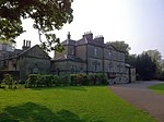
| |||
| The Parish Church Polmont | 55°59′40″N 3°42′22″W / 55.994508°N 3.706234°W | Category B | 8305 | 
| |||
| Lodge, Polmont House | 55°59′07″N 3°42′48″W / 55.985368°N 3.71343°W | Category C(S) | 13680 |
| |||
| Stables, Avondale House | 55°59′39″N 3°40′46″W / 55.994048°N 3.67955°W | Category B | 8307 |
| |||
| Folly, Avondale Park | 55°59′29″N 3°40′43″W / 55.99139°N 3.678746°W | Category B | 8308 |
| |||
| Bothkennar Parish Church | 56°01′54″N 3°45′40″W / 56.031577°N 3.761153°W | Category B | 8310 |
| |||
| Dovecot, Carron House | 56°01′27″N 3°46′13″W / 56.024229°N 3.77035°W | Category B | 8314 |
| |||
| Dovecot, Dovecot Road, Westquarter | 55°59′21″N 3°44′37″W / 55.989061°N 3.743556°W | Category A | 8315 | 
| |||
| Grangemouth Station Road, Former La Scala Cinema | 56°01′11″N 3°43′19″W / 56.019854°N 3.722065°W | Category C(S) | 50873 | 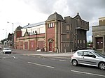
| |||
| Carronflats Road, Abbotsgrange Middle School | 56°00′59″N 3°42′56″W / 56.016466°N 3.715577°W | Category B | 34045 | 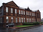
| |||
| School House, Polmont | 55°59′40″N 3°42′19″W / 55.994385°N 3.705411°W | Category C(S) | 8300 |
| |||
| Parkhill, Dovecot | 55°59′23″N 3°43′11″W / 55.989595°N 3.719613°W | Category B | 8302 |
| |||
| Bothkennar Manse | 56°01′55″N 3°45′45″W / 56.03197°N 3.762584°W | Category B | 8311 |
| |||
| Old Church, Polmont | 55°59′42″N 3°42′23″W / 55.994921°N 3.706269°W | Category C(S) | 8316 |
| |||
| Kinneil House, Polmont (Formerly The Manse) | 55°59′37″N 3°42′29″W / 55.993512°N 3.708098°W | Category B | 8299 |
| |||
| Ronaldshay Crescent And Park Road Grange Church And Church Hall | 56°01′04″N 3°43′06″W / 56.017661°N 3.718229°W | Category B | 34046 |
| |||
| Westerton Farm House | 56°01′47″N 3°46′04″W / 56.029792°N 3.76778°W | Category C(S) | 8312 |
|

Key[]
The scheme for classifying buildings in Scotland is:
- Category A: "buildings of national or international importance, either architectural or historic; or fine, little-altered examples of some particular period, style or building type."[1]
- Category B: "buildings of regional or more than local importance; or major examples of some particular period, style or building type, which may have been altered."[1]
- Category C: "buildings of local importance; lesser examples of any period, style, or building type, as originally constructed or moderately altered; and simple traditional buildings which group well with other listed buildings."[1]
In March 2016 there were 47,288 listed buildings in Scotland. Of these, 8% were Category A, and 50% were Category B, with the remaining 42% being Category C.[2]
See also[]
Notes[]
- ^ Sometimes known as OSGB36, the grid reference (where provided) is based on the British national grid reference system used by the Ordnance Survey.
• "Guide to National Grid". Ordnance Survey. Retrieved 12 December 2007.
• "Get-a-map". Ordnance Survey. Retrieved 17 December 2007. - ^ Historic Environment Scotland assign a unique alphanumeric identifier to each designated site in Scotland, for listed buildings this always begins with "LB", for example "LB12345".
References[]
- All entries, addresses and coordinates are based on data from Historic Scotland. This data falls under the Open Government Licence
- ^ a b c "What is Listing?". Historic Environment Scotland. Retrieved 29 May 2018.
- ^ Scotland's Historic Environment Audit 2016 (PDF). Historic Environment Scotland and the Built Environment Forum Scotland. pp. 15–16. Retrieved 29 May 2018.
Categories:
- Lists of listed buildings in Falkirk (council area)
- Grangemouth