List of listed buildings in New Monkland, North Lanarkshire
This is a list of listed buildings in the parish of in North Lanarkshire, Scotland.
List[]
| Name | Location | Date Listed | Grid Ref. [note 1] | Geo-coordinates | Notes | LB Number [note 2] | Image |
|---|---|---|---|---|---|---|---|
| Cleddans Former Stables | 55°54′32″N 4°00′48″W / 55.908797°N 4.013214°W | Category B | 14208 | 
| |||
| Glenboig, Glenboig Farm Road, Glenboig Farmhouse | 55°54′01″N 4°02′16″W / 55.900285°N 4.037903°W | Category B | 19250 |
| |||
| Parish Church | 55°53′12″N 3°59′44″W / 55.886768°N 3.995683°W | Category B | 19676 | 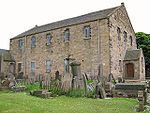
| |||
| Millcroft Former Cornmill | 55°55′27″N 3°59′56″W / 55.924201°N 3.998872°W | Category B | 18438 |
| |||
| Rochsoles | 55°53′13″N 3°59′21″W / 55.886827°N 3.989258°W | Category B | 14205 |
| |||
| Glenvmavis, Yetts Hole Road, Braidenhill Farmhouse | 55°52′54″N 4°00′49″W / 55.881796°N 4.013495°W | Category B | 19251 |
| |||
| Watch House And Churchyard | 55°53′12″N 3°59′42″W / 55.88669°N 3.99496°W | Category B | 14204 | 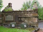
| |||
| Auchingray | 55°53′17″N 3°50′45″W / 55.888057°N 3.845758°W | Category C(S) | 14206 |
| |||
| Cleddans House And Garden Terrace Steps To South | 55°54′30″N 4°00′47″W / 55.908287°N 4.013076°W | Category B | 14207 |
|

Key[]
The scheme for classifying buildings in Scotland is:
- Category A: "buildings of national or international importance, either architectural or historic; or fine, little-altered examples of some particular period, style or building type."[1]
- Category B: "buildings of regional or more than local importance; or major examples of some particular period, style or building type, which may have been altered."[1]
- Category C: "buildings of local importance; lesser examples of any period, style, or building type, as originally constructed or moderately altered; and simple traditional buildings which group well with other listed buildings."[1]
In March 2016 there were 47,288 listed buildings in Scotland. Of these, 8% were Category A, and 50% were Category B, with the remaining 42% being Category C.[2]
See also[]
Notes[]
- ^ Sometimes known as OSGB36, the grid reference (where provided) is based on the British national grid reference system used by the Ordnance Survey.
• "Guide to National Grid". Ordnance Survey. Retrieved 2007-12-12.
• "Get-a-map". Ordnance Survey. Retrieved 2007-12-17. - ^ Historic Environment Scotland assign a unique alphanumeric identifier to each designated site in Scotland, for listed buildings this always begins with "LB", for example "LB12345".
References[]
- All entries, addresses and coordinates are based on data from Historic Scotland. This data falls under the Open Government Licence
- ^ a b c "What is Listing?". Historic Environment Scotland. Retrieved 29 May 2018.
- ^ Scotland's Historic Environment Audit 2016 (PDF). Historic Environment Scotland and the Built Environment Forum Scotland. pp. 15–16. Retrieved 29 May 2018.
Categories:
- Lists of listed buildings in North Lanarkshire