List of listed buildings in Ormiston, East Lothian
This is a list of listed buildings in the parish of Ormiston in East Lothian, Scotland.
List[]
| Name | Location | Date Listed | Grid Ref. [note 1] | Geo-coordinates | Notes | LB Number [note 2] | Image |
|---|---|---|---|---|---|---|---|
| Ormiston, The Old Hall, Adjoining Buildings, Former Stable Range And Walled Garden | 55°53′53″N 2°56′36″W / 55.898073°N 2.94337°W | Category B | 19066 | 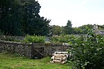
| |||
| 5 The Wynd, Lyn's Corner Shop And Avenue House | 55°54′46″N 2°56′24″W / 55.912762°N 2.940063°W | Category C(S) | 19068 | 
| |||
| Main Street, Ormiston House (Former Manse) With Out-Buildings, Railings And Retaining Walls | 55°54′48″N 2°56′16″W / 55.913472°N 2.937712°W | Category B | 17559 |
| |||
| 24 And 26 Main Street (Including Ormiston Post Office) | 55°54′47″N 2°56′24″W / 55.913033°N 2.939878°W | Category C(S) | 17540 |
| |||
| Main Street, Dominic Molloy's Cottage | 55°54′47″N 2°56′26″W / 55.912929°N 2.940675°W | Category C(S) | 17544 |
| |||
| Main Street, Fawns Park | 55°54′47″N 2°56′14″W / 55.913126°N 2.937112°W | Category B | 17554 |
| |||
| Main Street, Moffat Monument | 55°54′49″N 2°56′08″W / 55.913561°N 2.935443°W | Category B | 17556 | 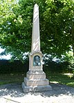
| |||
| Main Street, Ormiston Parish Church With Retaining Walls | 55°54′48″N 2°56′18″W / 55.913386°N 2.93843°W | Category B | 19058 |
| |||
| Ormiston Hall, Belsis Cottage And Walled Garden | 55°54′04″N 2°56′21″W / 55.90108°N 2.939093°W | Category B | 19062 |
| |||
| Ormiston Hall Dovecot | 55°53′45″N 2°56′28″W / 55.895763°N 2.941123°W | Category B | 19063 |
| |||
| Main Street, Oak House With Retaining Walls | 55°54′46″N 2°56′22″W / 55.912651°N 2.939388°W | Category B | 17557 |
| |||
| Ormistonhall Lodge | 55°54′14″N 2°56′24″W / 55.903913°N 2.939977°W | Category B | 19064 |
| |||
| Ormiston Hall, South Lodge With Gatepiers And Walls | 55°53′40″N 2°56′25″W / 55.894314°N 2.940288°W | Category C(S) | 19065 |
| |||
| High Street, Benham | 55°54′45″N 2°56′29″W / 55.91251°N 2.941305°W | Category C(S) | 17539 |
| |||
| Main Street, Coach House | 55°54′48″N 2°56′07″W / 55.913427°N 2.93536°W | Category B | 17543 |
| |||
| Main Street, Througburn | 55°54′48″N 2°56′12″W / 55.913212°N 2.936538°W | Category C(S) | 19060 |
| |||
| Main Street, Beech House With Former Outbuildings And Retaining Walls | 55°54′50″N 2°56′09″W / 55.91381°N 2.935817°W | Category B | 17542 |
| |||
| Main Street, Beech Cottage | 55°54′48″N 2°56′17″W / 55.913372°N 2.937934°W | Category B | 17541 |
| |||
| Main Street, Hillview | 55°54′48″N 2°56′08″W / 55.913372°N 2.935582°W | Category B | 17555 |
| |||
| Main Street, Ormiston War Memorial | 55°54′46″N 2°56′33″W / 55.912653°N 2.942636°W | Category B | 19059 |
| |||
| Ormiston Primary School, Principal Range With Retaining Walls, Piers And Railings | 55°54′41″N 2°56′28″W / 55.911451°N 2.941215°W | Category B | 19067 |
| |||
| Main Street, Cross | 55°54′47″N 2°56′20″W / 55.913006°N 2.938757°W | Category B | 17545 |
| |||
| Ormiston Bridge | 55°54′36″N 2°56′27″W / 55.909908°N 2.940922°W | Category B | 19061 |
| |||
| Main Street, Old Schoolhouse | 55°54′47″N 2°56′12″W / 55.913174°N 2.936761°W | Category B | 17558 |
|

Key[]
The scheme for classifying buildings in Scotland is:
- Category A: "buildings of national or international importance, either architectural or historic; or fine, little-altered examples of some particular period, style or building type."[1]
- Category B: "buildings of regional or more than local importance; or major examples of some particular period, style or building type, which may have been altered."[1]
- Category C: "buildings of local importance; lesser examples of any period, style, or building type, as originally constructed or moderately altered; and simple traditional buildings which group well with other listed buildings."[1]
In March 2016 there were 47,288 listed buildings in Scotland. Of these, 8% were Category A, and 50% were Category B, with the remaining 42% being Category C.[2]
See also[]
Notes[]
- ^ Sometimes known as OSGB36, the grid reference (where provided) is based on the British national grid reference system used by the Ordnance Survey.
• "Guide to National Grid". Ordnance Survey. Retrieved 2007-12-12.
• "Get-a-map". Ordnance Survey. Retrieved 2007-12-17. - ^ Historic Environment Scotland assign a unique alphanumeric identifier to each designated site in Scotland, for listed buildings this always begins with "LB", for example "LB12345".
References[]
- All entries, addresses and coordinates are based on data from Historic Scotland. This data falls under the Open Government Licence
- ^ a b c "What is Listing?". Historic Environment Scotland. Retrieved 29 May 2018.
- ^ Scotland's Historic Environment Audit 2016 (PDF). Historic Environment Scotland and the Built Environment Forum Scotland. pp. 15–16. Retrieved 29 May 2018.
Categories:
- Lists of listed buildings in East Lothian
- Ormiston