List of listed buildings in Saddell And Skipness, Argyll and Bute
This is a list of listed buildings in the parish of in Argyll and Bute, Scotland.
List[]
| Name | Location | Date Listed | Grid Ref. [note 1] | Geo-coordinates | Notes | LB Number [note 2] | Image |
|---|---|---|---|---|---|---|---|
| Bridge I, Lephin Corrach Burn, Torrisdale Estate | 55°34′03″N 5°30′06″W / 55.567607°N 5.501556°W | Category C(S) | 18398 | 
| |||
| Saddell Burial Ground, Campbell Of Glen Carradale Burial Enclosure | 55°31′55″N 5°30′42″W / 55.531919°N 5.511649°W | Category C(S) | 18482 |
| |||
| Cour House Saddell | 55°40′40″N 5°27′48″W / 55.677863°N 5.463404°W | Category A | 18360 |
| |||
| Saddell Abbey | 55°31′55″N 5°30′43″W / 55.531918°N 5.511998°W | Category B | 18402 |
| |||
| Gate-Lodge And Gate-Way Skipness Estate | 55°46′08″N 5°20′37″W / 55.768886°N 5.343522°W | Category C(S) | 18358 |
| |||
| Torrisdale Castle | 55°34′08″N 5°30′05″W / 55.568801°N 5.501297°W | Category B | 18396 |
| |||
| Torrisdale Gate-Lodge And Gateway Torrisdale Estate Saddell - Skipness Road | 55°33′58″N 5°29′46″W / 55.566179°N 5.49616°W | Category B | 18400 |
| |||
| Saddell Castle | 55°31′39″N 5°30′17″W / 55.527418°N 5.504622°W | Category A | 18403 | 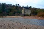
| |||
| Saddell House | 55°31′47″N 5°30′05″W / 55.529812°N 5.501395°W | Category B | 18404 |
| |||
| St. Brendan's Church Of Scotland Skipness Village | 55°46′07″N 5°20′40″W / 55.768565°N 5.344403°W | Category C(S) | 18359 |
| |||
| Saddell Parish Church, Dippen | 55°34′59″N 5°29′55″W / 55.58294°N 5.498636°W | Category C(S) | 18392 |
| |||
| Grogport House (Grogport Old Manse) | 55°38′05″N 5°28′48″W / 55.6348°N 5.480087°W | Category B | 18405 |
| |||
| Gate-House And Stable ('The Arch') Near Torresdale Castle | 55°34′06″N 5°30′10″W / 55.568373°N 5.502766°W | Category B | 18397 |
| |||
| Carradale House | 55°35′03″N 5°28′54″W / 55.584198°N 5.48162°W | Category B | 18394 |
| |||
| Bridge Ii, Torrisdale Estate | 55°34′08″N 5°30′00″W / 55.568941°N 5.499865°W | Category C(S) | 18399 |
| |||
| Glenreasdell Mains Claonaig - Tarbert Road | 55°46′17″N 5°24′28″W / 55.771433°N 5.407826°W | Category C(S) | 18407 |
| |||
| Torrisdale Square | 55°34′18″N 5°29′48″W / 55.571779°N 5.496532°W | Category B | 18395 |
| |||
| Torrisdale Bridge Torrisdale Water Saddell - Skipness Road | 55°33′59″N 5°29′45″W / 55.56638°N 5.495718°W | Category B | 18401 |
| |||
| Skipness Castle | 55°46′05″N 5°20′10″W / 55.768122°N 5.336216°W | Category A | 18408 | 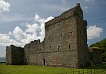
| |||
| St. Brendan's Chapel (Kilbrannan) Skipness Estate | 55°45′57″N 5°19′57″W / 55.765813°N 5.332542°W | Category A | 18409 | 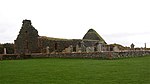
| |||
| Dippen Bridge, Carradale Water, Saddell - Skipness Road, Dippen | 55°34′56″N 5°29′43″W / 55.582232°N 5.495398°W | Category B | 18393 |
| |||
| Skipness Parish Church Claonaig | 55°45′23″N 5°23′42″W / 55.756296°N 5.395057°W | Category B | 18406 |
| |||
| Saddell Burial Ground, Campbell Of Glen Saddell Burial Enclosure | 55°31′55″N 5°30′46″W / 55.531901°N 5.5129°W | Category B | 18483 |
|

Key[]
The scheme for classifying buildings in Scotland is:
- Category A: "buildings of national or international importance, either architectural or historic; or fine, little-altered examples of some particular period, style or building type."[1]
- Category B: "buildings of regional or more than local importance; or major examples of some particular period, style or building type, which may have been altered."[1]
- Category C: "buildings of local importance; lesser examples of any period, style, or building type, as originally constructed or moderately altered; and simple traditional buildings which group well with other listed buildings."[1]
In March 2016 there were 47,288 listed buildings in Scotland. Of these, 8% were Category A, and 50% were Category B, with the remaining 42% being Category C.[2]
See also[]
Notes[]
- ^ Sometimes known as OSGB36, the grid reference (where provided) is based on the British national grid reference system used by the Ordnance Survey.
• "Guide to National Grid". Ordnance Survey. Retrieved 2007-12-12.
• "Get-a-map". Ordnance Survey. Retrieved 2007-12-17. - ^ Historic Environment Scotland assign a unique alphanumeric identifier to each designated site in Scotland, for listed buildings this always begins with "LB", for example "LB12345".
References[]
- All entries, addresses and coordinates are based on data from Historic Scotland. This data falls under the Open Government Licence
- ^ a b c "What is Listing?". Historic Environment Scotland. Retrieved 29 May 2018.
- ^ Scotland's Historic Environment Audit 2016 (PDF). Historic Environment Scotland and the Built Environment Forum Scotland. pp. 15–16. Retrieved 29 May 2018.
Categories:
- Lists of listed buildings in Argyll and Bute
- Kintyre