List of listed buildings in Shotts, North Lanarkshire
This is a list of listed buildings in the parish of in North Lanarkshire, Scotland.
List[]
| Name | Location | Date Listed | Grid Ref. [note 1] | Geo-coordinates | Notes | LB Number [note 2] | Image |
|---|---|---|---|---|---|---|---|
| Kirk Of Shotts And Graveyard | 55°50′45″N 3°50′59″W / 55.845831°N 3.849793°W | Category B | 18228 | 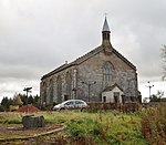
| |||
| South Calder Bridge (West Of Murdostoun Castle) | 55°47′41″N 3°53′25″W / 55.794764°N 3.890282°W | Category B | 18439 | 
| |||
| Hartwood, Hartwood Hospital, Nurses' Home | 55°48′32″N 3°50′26″W / 55.80897°N 3.840672°W | Category C(S) | 49672 |
| |||
| 84 Station Road, St Patrick's Roman Catholic Church And Presbytery | 55°49′10″N 3°47′45″W / 55.819356°N 3.795862°W | Category B | 50146 |
| |||
| Greystone Farm | 55°52′23″N 3°55′25″W / 55.873024°N 3.923655°W | Category C(S) | 18229 |
| |||
| Shotts, Calderhead Road, Centrelink 5 (Former Cummins Engine Company Ltd), Including Boiler House To Nw And Entrance Gates | 55°49′39″N 3°49′02″W / 55.827418°N 3.817212°W | Category A | 50013 |
| |||
| Murdostoun Estate, West Lodge, Including Gatepiers | 55°47′51″N 3°53′32″W / 55.797636°N 3.892288°W | Category B | 18440 |
| |||
| Easter Moffat House | 55°52′23″N 3°55′19″W / 55.872996°N 3.921991°W | Category B | 18230 |
| |||
| Murdostoun Castle | 55°47′41″N 3°52′30″W / 55.794763°N 3.875064°W | Category B | 14187 | 
| |||
| Murdostoun Castle Dovecot | 55°47′41″N 3°52′20″W / 55.794637°N 3.872139°W | Category B | 14188 |
| |||
| Murdostoun Castle, Wellhead | 55°47′41″N 3°52′20″W / 55.794698°N 3.872237°W | Category B | 14189 |
| |||
| Murdostoun Castle, Lodge | 55°47′44″N 3°51′32″W / 55.795493°N 3.858955°W | Category B | 14190 |
| |||
| Hartwood, Hartwood Hospital | 55°48′36″N 3°50′53″W / 55.809963°N 3.848139°W | Category B | 43858 |
| |||
| Furnace Bank And Hot Blast Tower, Shotts Ironworks, Burnbrae Road | 55°49′06″N 3°47′23″W / 55.818359°N 3.789639°W | Category B | 43491 | 
| |||
| Fortissat House | 55°50′00″N 3°49′52″W / 55.833225°N 3.830991°W | Category C(S) | 14192 |
| |||
| Easter Moffat House, Former Stables | 55°52′23″N 3°55′25″W / 55.873024°N 3.923655°W | Category C(S) | 18231 |
|
Key[]
The scheme for classifying buildings in Scotland is:
- Category A: "buildings of national or international importance, either architectural or historic; or fine, little-altered examples of some particular period, style or building type."[1]
- Category B: "buildings of regional or more than local importance; or major examples of some particular period, style or building type, which may have been altered."[1]
- Category C: "buildings of local importance; lesser examples of any period, style, or building type, as originally constructed or moderately altered; and simple traditional buildings which group well with other listed buildings."[1]
In March 2016 there were 47,288 listed buildings in Scotland. Of these, 8% were Category A, and 50% were Category B, with the remaining 42% being Category C.[2]
See also[]
Notes[]
- ^ Sometimes known as OSGB36, the grid reference (where provided) is based on the British national grid reference system used by the Ordnance Survey.
• "Guide to National Grid". Ordnance Survey. Retrieved 2007-12-12.
• "Get-a-map". Ordnance Survey. Retrieved 2007-12-17. - ^ Historic Environment Scotland assign a unique alphanumeric identifier to each designated site in Scotland, for listed buildings this always begins with "LB", for example "LB12345".
References[]
- All entries, addresses and coordinates are based on data from Historic Scotland. This data falls under the Open Government Licence
- ^ a b c "What is Listing?". Historic Environment Scotland. Retrieved 29 May 2018.
- ^ Scotland's Historic Environment Audit 2016 (PDF). Historic Environment Scotland and the Built Environment Forum Scotland. pp. 15–16. Retrieved 29 May 2018.
Categories:
- Lists of listed buildings in North Lanarkshire