List of listed buildings in Spott, East Lothian
This is a list of listed buildings in the parish of Spott in East Lothian, Scotland.
List[]
| Name | Location | Date Listed | Grid Ref. [note 1] | Geo-coordinates | Notes | LB Number [note 2] | Image |
|---|---|---|---|---|---|---|---|
| Easter Broomhouse Cartshed And Granary | 55°59′01″N 2°30′49″W / 55.983556°N 2.513696°W | Category B | 14759 | 
| |||
| Spott Church With Session House, Graveyard Walls And Railings, (Church Of Scotland) | 55°58′20″N 2°31′28″W / 55.972154°N 2.524376°W | Category B | 14762 |
| |||
| Spott House, Lodge With Gatepiers And Quadrants | 55°58′19″N 2°31′22″W / 55.972026°N 2.522852°W | Category C(S) | 14787 |
| |||
| Bourhouse (Bower House) Dovecot | 55°58′56″N 2°32′01″W / 55.982213°N 2.533679°W | Category A | 14757 | 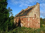
| |||
| Bower House (Bourhouse) Lodge With Gatepiers And Parapet | 55°59′01″N 2°32′04″W / 55.983567°N 2.534371°W | Category B | 14758 |
| |||
| Halls Farm Cottages | 55°56′49″N 2°33′30″W / 55.946811°N 2.558266°W | Category C(S) | 14761 |
| |||
| Spott House, Home Farm Cottages | 55°58′07″N 2°30′52″W / 55.968737°N 2.514396°W | Category B | 14785 |
| |||
| Spott, Main Street, Ivybank | 55°58′25″N 2°31′20″W / 55.97369°N 2.522233°W | Category B | 14790 |
| |||
| Halls Farmhouse With Retaining Walls And Gatepiers | 55°56′48″N 2°33′23″W / 55.946685°N 2.556391°W | Category A | 14760 |
| |||
| Spott Dovecot | 55°58′20″N 2°31′20″W / 55.972244°N 2.522118°W | Category A | 14763 | 
| |||
| Spott House, Kennels With Railings | 55°58′01″N 2°31′04″W / 55.966971°N 2.517689°W | Category C(S) | 14786 |
| |||
| Spott, Main Street, Rosebank And Cottage | 55°58′24″N 2°31′21″W / 55.973302°N 2.522613°W | Category B | 14789 |
| |||
| Spott House With Boundary Walls, Piers, "Chapel" And Game Larder | 55°58′09″N 2°30′56″W / 55.969226°N 2.515572°W | Category B | 14784 |
| |||
| Spott House, Stable Court And Groom's House | 55°58′08″N 2°30′54″W / 55.968761°N 2.514941°W | Category B | 14788 |
| |||
| Bower House (Bourhouse) With Gates, Wellhead, Terrace And Boundary Walls | 55°58′52″N 2°32′10″W / 55.981007°N 2.53621°W | Category A | 14756 |
| |||
| Spott, High Road, Turner's House (Formerly 1 Main Street) | 55°58′13″N 2°31′40″W / 55.970378°N 2.527732°W | Category C(S) | 14791 |
| |||
| Spott, Main Street, Schoolhouse Community Centre | 55°58′17″N 2°31′32″W / 55.97152°N 2.525617°W | Category C(S) | 14792 |
| |||
| The Standards | 55°58′55″N 2°32′17″W / 55.982042°N 2.537939°W | Category C(S) | 14793 |
| |||
| Wester Broomhouse, Wellhead Tower | 55°58′38″N 2°31′44″W / 55.977274°N 2.528755°W | Category C(S) | 14794 |
|

Key[]
The scheme for classifying buildings in Scotland is:
- Category A: "buildings of national or international importance, either architectural or historic; or fine, little-altered examples of some particular period, style or building type."[1]
- Category B: "buildings of regional or more than local importance; or major examples of some particular period, style or building type, which may have been altered."[1]
- Category C: "buildings of local importance; lesser examples of any period, style, or building type, as originally constructed or moderately altered; and simple traditional buildings which group well with other listed buildings."[1]
In March 2016 there were 47,288 listed buildings in Scotland. Of these, 8% were Category A, and 50% were Category B, with the remaining 42% being Category C.[2]
See also[]
Notes[]
- ^ Sometimes known as OSGB36, the grid reference (where provided) is based on the British national grid reference system used by the Ordnance Survey.
• "Guide to National Grid". Ordnance Survey. Retrieved 2007-12-12.
• "Get-a-map". Ordnance Survey. Retrieved 2007-12-17. - ^ Historic Environment Scotland assign a unique alphanumeric identifier to each designated site in Scotland, for listed buildings this always begins with "LB", for example "LB12345".
References[]
- All entries, addresses and coordinates are based on data from Historic Scotland. This data falls under the Open Government Licence
- ^ a b c "What is Listing?". Historic Environment Scotland. Retrieved 29 May 2018.
- ^ Scotland's Historic Environment Audit 2016 (PDF). Historic Environment Scotland and the Built Environment Forum Scotland. pp. 15–16. Retrieved 29 May 2018.
Categories:
- Lists of listed buildings in East Lothian