List of listed buildings in Strathblane, Stirling
This is a list of listed buildings in the parish of Strathblane in Stirling, Scotland.
List[]
| Name | Location | Date Listed | Grid Ref. [note 1] | Geo-coordinates | Notes | LB Number [note 2] | Image |
|---|---|---|---|---|---|---|---|
| Mugdock Castle And Chapel | 55°57′56″N 4°19′29″W / 55.965619°N 4.324714°W | Category A | 15330 | 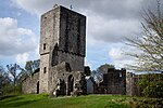
| |||
| Leddrie Green House | 55°59′21″N 4°18′06″W / 55.989223°N 4.301583°W | Category B | 15335 | 
| |||
| Tower, Near Souter Lodge, Mugdock | 55°57′49″N 4°18′58″W / 55.963749°N 4.316173°W | Category C(S) | 15331 |
| |||
| Ballewan Byewash 1 (Former Glasgow Corporation Water Works) | 55°59′59″N 4°19′51″W / 55.999621°N 4.330781°W | Category B | 51141 |
| |||
| Ballewan Byewash 3 (Former Glasgow Corporation Water Works) | 55°59′50″N 4°19′38″W / 55.997116°N 4.327295°W | Category B | 51143 |
| |||
| Townhead Of Auchengillan | 55°59′29″N 4°22′32″W / 55.991386°N 4.375616°W | Category B | 15333 |
| |||
| Blane Valley Valve Houses Including 1856 Valve House, 1932 Valve House, Ventilation Shaft, Boundary Wall And Gates (Former Glasgow Corporation Water Works) | 55°59′28″N 4°19′12″W / 55.991107°N 4.319942°W | Category B | 51146 |
| |||
| Spittal Glen, Ballewan Aqueduct Bridge (Former Glasgow Corporation Water Works) | 56°00′05″N 4°20′02″W / 56.001441°N 4.333874°W | Category B | 51147 |
| |||
| Carbeth Guthrie House | 55°59′08″N 4°21′37″W / 55.985508°N 4.360185°W | Category B | 19738 |
| |||
| Duntreath Castle | 56°00′01″N 4°20′54″W / 56.000283°N 4.348448°W | Category B | 15317 |
| |||
| Ballewan House | 55°59′56″N 4°20′04″W / 55.99886°N 4.334392°W | Category B | 15318 |
| |||
| Ballewan Byewash 2 (Former Glasgow Corporation Water Works | 55°59′57″N 4°19′49″W / 55.999136°N 4.330271°W | Category B | 51142 |
| |||
| Blairgar Byewash (Former Glasgow Corporation Water Works) | 56°00′50″N 4°21′22″W / 56.013824°N 4.356169°W | Category B | 51144 |
| |||
| Blairquhosh Byewash (Former Glasgow Corporation Water Works) | 56°00′37″N 4°21′20″W / 56.010151°N 4.355544°W | Category B | 51145 |
| |||
| Parish Church | 55°59′09″N 4°18′14″W / 55.985961°N 4.303938°W | Category B | 15316 |
| |||
| Low Auchengillan | 55°59′21″N 4°22′40″W / 55.989253°N 4.37765°W | Category B | 15332 |
| |||
| Craigend Stables | 55°58′21″N 4°19′51″W / 55.972541°N 4.330819°W | Category B | 15334 |
| |||
| Mugdock, Dineiddwg And Front Garden Gate | 55°57′42″N 4°18′30″W / 55.96153°N 4.308446°W | Category B | 15336 |
| |||
| Mugdock, Dineiddwg, Main Entrance Gate Pier And Gate At West Lodge | 55°57′42″N 4°18′30″W / 55.96153°N 4.308446°W | Category B | 15337 |
| |||
| Clachan Cottage, Carbeth | 55°59′03″N 4°21′23″W / 55.984141°N 4.356447°W | Category C(S) | 13849 |
| |||
| Mugdock Country Park, Craigend Castle | 55°58′12″N 4°20′00″W / 55.970129°N 4.33335°W | Category C(S) | 50821 | 
|
Key[]
The scheme for classifying buildings in Scotland is:
- Category A: "buildings of national or international importance, either architectural or historic; or fine, little-altered examples of some particular period, style or building type."[1]
- Category B: "buildings of regional or more than local importance; or major examples of some particular period, style or building type, which may have been altered."[1]
- Category C: "buildings of local importance; lesser examples of any period, style, or building type, as originally constructed or moderately altered; and simple traditional buildings which group well with other listed buildings."[1]
In March 2016 there were 47,288 listed buildings in Scotland. Of these, 8% were Category A, and 50% were Category B, with the remaining 42% being Category C.[2]
Notes[]
- ^ Sometimes known as OSGB36, the grid reference (where provided) is based on the British national grid reference system used by the Ordnance Survey.
• "Guide to National Grid". Ordnance Survey. Retrieved 2007-12-12.
• "Get-a-map". Ordnance Survey. Retrieved 2007-12-17. - ^ Historic Environment Scotland assign a unique alphanumeric identifier to each designated site in Scotland, for listed buildings this always begins with "LB", for example "LB12345".
References[]
- All entries, addresses and coordinates are based on data from Historic Scotland. This data falls under the Open Government Licence
- ^ a b c "What is Listing?". Historic Environment Scotland. Retrieved 29 May 2018.
- ^ Scotland's Historic Environment Audit 2016 (PDF). Historic Environment Scotland and the Built Environment Forum Scotland. pp. 15–16. Retrieved 29 May 2018.
Categories:
- Lists of listed buildings in Stirling (council area)