List of listed buildings in Walls And Flotta, Orkney
This is a list of listed buildings in the parish of in Orkney, Scotland.
List[]
| Name | Location | Date Listed | Grid Ref. [note 1] | Geo-coordinates | Notes | LB Number [note 2] | Image |
|---|---|---|---|---|---|---|---|
| Walls, (Hoy), Melsetter House Including Garden Walls And Former Kennels | 58°47′08″N 3°15′48″W / 58.785614°N 3.263284°W | Category A | 18712 | 
| |||
| Flotta (Hoy), Whome Kiln And Barn | 58°49′39″N 3°06′30″W / 58.827481°N 3.108422°W | Category C(S) | 48333 |
| |||
| Walls (Hoy), Longhope Lifeboat Station | 58°46′47″N 3°13′41″W / 58.779678°N 3.227939°W | Category B | 48347 |
| |||
| Walls (Hoy), Melsetter, Gardener's Cottage, Including Stone Setts And Garden Wall To North | 58°47′09″N 3°15′52″W / 58.785883°N 3.264315°W | Category B | 48366 |
| |||
| Walls (Hoy), North Ness, Milestone | 58°48′23″N 3°12′13″W / 58.806413°N 3.203507°W | Category C(S) | 48375 |
| |||
| South Walls (Hoy), Longhope, Church Of St Columba, (Longhope Parish Church, Church Of Scotland) | 58°47′58″N 3°11′31″W / 58.799354°N 3.191823°W | Category C(S) | 18809 |
| |||
| Flotta (Hoy), Bow Old Farmhouse, Byre And Barn | 58°49′24″N 3°05′51″W / 58.82329°N 3.097585°W | Category C(S) | 18814 |
| |||
| South Walls (Hoy), Kirbuster, Letter Box | 58°48′04″N 3°09′36″W / 58.80101°N 3.159879°W | Category C(S) | 48336 |
| |||
| South Walls (Hoy), Longhope, Milestone To North East Of Morven | 58°48′04″N 3°11′00″W / 58.801246°N 3.183373°W | Category C(S) | 48340 |
| |||
| South Walls, (Hoy), South Ness, War Memorial | 58°47′59″N 3°12′24″W / 58.799611°N 3.206698°W | Category C(S) | 48345 |
| |||
| Walls (Hoy), The Garrison (Former Garrison Theatre) | 58°48′45″N 3°12′02″W / 58.812367°N 3.200632°W | Category C(S) | 48346 |
| |||
| Walls (Hoy), Milestone To West Of Lyrawa Bay | 58°52′19″N 3°14′12″W / 58.871988°N 3.236637°W | Category C(S) | 48358 |
| |||
| Walls (Hoy), Melsetter House, Lodge, Gates, Gatepiers And Field Boundary Walls And Gatepiers | 58°47′10″N 3°15′50″W / 58.786166°N 3.263858°W | Category C(S) | 48363 |
| |||
| Walls (Hoy), Melsetter, The Laundry House, Including Walled Yard To North And Wall And Gatepiers To South East | 58°47′08″N 3°15′53″W / 58.785465°N 3.264784°W | Category B | 48368 |
| |||
| Walls (Hoy), Milestone To East Of Pegal Hill | 58°51′47″N 3°13′20″W / 58.863027°N 3.222256°W | Category C(S) | 48377 |
| |||
| South Walls (Hoy), Cantick Head Lighthouse Including Keepers' Cottages, Sheds, Perimeter Wall And Sundial | 58°47′14″N 3°07′54″W / 58.787197°N 3.13153°W | Category B | 18710 |
| |||
| South Walls (Hoy), Crowtaing, Pigsty | 58°47′51″N 3°08′25″W / 58.797627°N 3.140349°W | Category C(S) | 48334 |
| |||
| South Walls (Hoy), Glebelands (Former South Walls Manse), Including Walled Garden And Boundary Wall | 58°47′41″N 3°12′03″W / 58.794699°N 3.200783°W | Category C(S) | 48337 |
| |||
| South Walls (Hoy), Milestone To South Of Kirbuster House | 58°48′03″N 3°09′32″W / 58.800964°N 3.158977°W | Category C(S) | 48339 |
| |||
| South Walls (Hoy), Quoy | 58°47′36″N 3°10′19″W / 58.793356°N 3.171961°W | Category C(S) | 48343 |
| |||
| Walls (Hoy), Lyness Pier | 58°50′01″N 3°11′27″W / 58.833726°N 3.190821°W | Category C(S) | 48349 |
| |||
| Walls (Hoy), Lyness, Milesone To West Of Haybrake | 58°49′57″N 3°12′25″W / 58.832518°N 3.206838°W | Category C(S) | 48355 |
| |||
| Walls (Hoy), Melsetter, The Estate Office, Including Boundary Wall And Adjacent Outhouse And Stone Flagged Yard And Gatepiers To West | 58°47′07″N 3°15′56″W / 58.785287°N 3.265573°W | Category B | 48365 |
| |||
| Walls (Hoy), Melsetter, The Hall, Including Gatepiers To West | 58°47′07″N 3°15′55″W / 58.785307°N 3.265314°W | Category B | 48367 |
| |||
| Walls (Hoy), Millhouse | 58°50′30″N 3°12′41″W / 58.841725°N 3.211507°W | Category C(S) | 48371 |
| |||
| Walls (Hoy), Wee Fea Naval Communications And Operational Centre | 58°49′54″N 3°13′29″W / 58.831757°N 3.224636°W | Category B | 48378 |
| |||
| Hoy, Lyness, Scapa Flow Visitor Centre, Former Steam Pumping Station And Oil Storage Tank | 58°50′01″N 3°11′48″W / 58.833734°N 3.196763°W | Category A | 50533 | 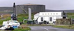
| |||
| Walls (Hoy), St John's Church (Church Of Scotland), Including Boundary Wall | 58°48′21″N 3°13′02″W / 58.805915°N 3.217268°W | Category C(S) | 47969 |
| |||
| Walls (Hoy), Lyness Naval Cemetery Including Pavilions, War Memorial And Boundary Walls | 58°50′00″N 3°12′37″W / 58.833294°N 3.210312°W | Category C(S) | 48348 |
| |||
| Walls (Hoy), Lyness, Haybrake, Granary | 58°49′55″N 3°12′21″W / 58.832068°N 3.205956°W | Category B | 48354 |
| |||
| Melsetter Farm, Steading | 58°47′03″N 3°16′05″W / 58.784193°N 3.268111°W | Category C(S) | 48361 |
| |||
| Walls (Hoy), Melsetter House, Kitchen Garden Including Tea-House And Doocot, Rookery Walls And Gatepiers | 58°47′05″N 3°15′50″W / 58.784827°N 3.263861°W | Category A | 48362 |
| |||
| Walls (Hoy), Melsetter, Walled Garden (Formerly Rose Garden) To Nw Of Melsetter House, Including Cartshed To West | 58°47′09″N 3°15′52″W / 58.785711°N 3.264447°W | Category B | 48370 |
| |||
| Walls (Hoy), Bridge To South East Of Pegal Hill | 58°51′34″N 3°13′36″W / 58.859546°N 3.226571°W | Category B | 48376 |
| |||
| South Walls (Hoy), Snelsetter | 58°46′55″N 3°10′31″W / 58.782055°N 3.175247°W | Category B | 44590 |
| |||
| South Walls (Hoy), South Ness, Ness House | 58°48′00″N 3°12′23″W / 58.800124°N 3.206526°W | Category B | 19662 |
| |||
| Walls (Hoy), 1 North Ness (Formerly The Ship Inn) | 58°48′19″N 3°12′13″W / 58.805162°N 3.203741°W | Category C(S) | 18811 |
| |||
| Walls (Hoy), Lyness, Former Metal Industry Shed | 58°49′52″N 3°11′59″W / 58.831058°N 3.199598°W | Category B | 48356 |
| |||
| Walls (Hoy), Lyness, Romney Hut | 58°50′06″N 3°11′49″W / 58.834999°N 3.19691°W | Category C(S) | 48357 |
| |||
| Walls (Hoy) Melsetter Farmhouse, Including Boundary Wall | 58°47′04″N 3°16′02″W / 58.784543°N 3.267241°W | Category C(S) | 48360 |
| |||
| Walls (Hoy), Melsetter Hill Burial Enclosure | 58°47′16″N 3°16′17″W / 58.787807°N 3.271391°W | Category C(S) | 48364 |
| |||
| Walls (Hoy), Melsetter, Spinning Cottage | 58°47′08″N 3°15′51″W / 58.785587°N 3.264269°W | Category B | 48369 |
| |||
| Walls (Hoy), Rysa Lodge, Including Garden Wall To South And East And Outbuildings To South West | 58°50′52″N 3°12′15″W / 58.847855°N 3.204269°W | Category A | 18714 |
| |||
| Flotta (Hoy), Flotta Church (Church Of Scotland), Including War Memorial To South And Boundary Wall | 58°49′14″N 3°05′55″W / 58.820542°N 3.098659°W | Category C(S) | 18813 | 
| |||
| South Walls (Hoy), Longhope, The Old Custom House (Including Westburn), Including Boundary Wall | 58°47′55″N 3°11′56″W / 58.79858°N 3.198788°W | Category B | 18709 |
| |||
| South Walls (Hoy), Milestone To North Of Gallow Tuag | 58°47′20″N 3°12′12″W / 58.788926°N 3.203421°W | Category C(S) | 48335 |
| |||
| South Walls (Hoy), Lythes, Milestone | 58°47′45″N 3°12′50″W / 58.795835°N 3.213801°W | Category C(S) | 48342 |
| |||
| South Walls (Hoy), Snelsetter Gatepier | 58°47′11″N 3°09′01″W / 58.786276°N 3.150322°W | Category C(S) | 48344 |
| |||
| Walls (Hoy), Muckle Rysa Including Garden Wall | 58°51′11″N 3°12′09″W / 58.853053°N 3.202629°W | Category B | 48373 |
| |||
| South Walls (Hoy), Osmondwall, Moodie Mausoleum And Graveyard | 58°47′17″N 3°09′13″W / 58.788097°N 3.153549°W | Category B | 19905 |
| |||
| South Walls (Hoy), Hillside | 58°48′07″N 3°08′52″W / 58.801819°N 3.147808°W | Category C(S) | 48338 |
| |||
| South Walls (Hoy), Longhope, Royal Hotel, Including Boundary Wall | 58°47′58″N 3°12′28″W / 58.799529°N 3.207717°W | Category C(S) | 48341 |
| |||
| Walls (Hoy), Milestone To North Of Millhouse | 58°50′36″N 3°12′41″W / 58.843307°N 3.211372°W | Category C(S) | 48372 |
| |||
| Walls (Hoy), Munitions Depot Sw Of Ore Farm | 58°49′16″N 3°12′31″W / 58.82123°N 3.208575°W | Category B | 48374 |
| |||
| Walls (Hoy), Lyness, Decontamination Shed | 58°50′03″N 3°12′30″W / 58.834192°N 3.208334°W | Category C(S) | 48353 |
| |||
| Walls (Hoy), Melsetter House, Chapel | 58°47′08″N 3°15′50″W / 58.78551°N 3.263903°W | Category A | 48359 |
|

Key[]
The scheme for classifying buildings in Scotland is:
- Category A: "buildings of national or international importance, either architectural or historic; or fine, little-altered examples of some particular period, style or building type."[1]
- Category B: "buildings of regional or more than local importance; or major examples of some particular period, style or building type, which may have been altered."[1]
- Category C: "buildings of local importance; lesser examples of any period, style, or building type, as originally constructed or moderately altered; and simple traditional buildings which group well with other listed buildings."[1]
In March 2016 there were 47,288 listed buildings in Scotland. Of these, 8% were Category A, and 50% were Category B, with the remaining 42% being Category C.[2]
See also[]
Notes[]
- ^ Sometimes known as OSGB36, the grid reference (where provided) is based on the British national grid reference system used by the Ordnance Survey.
• "Guide to National Grid". Ordnance Survey. Retrieved 2007-12-12.
• "Get-a-map". Ordnance Survey. Retrieved 2007-12-17. - ^ Historic Environment Scotland assign a unique alphanumeric identifier to each designated site in Scotland, for listed buildings this always begins with "LB", for example "LB12345".
References[]
- All entries, addresses and coordinates are based on data from Historic Scotland. This data falls under the Open Government Licence
- ^ a b c "What is Listing?". Historic Environment Scotland. Retrieved 29 May 2018.
- ^ Scotland's Historic Environment Audit 2016 (PDF). Historic Environment Scotland and the Built Environment Forum Scotland. pp. 15–16. Retrieved 29 May 2018.
Categories:
- Lists of listed buildings in Orkney