List of rivers of South Africa

A map showing South Africa's cities, main towns, selected villages, rivers, and its highest peak.
This is a list of rivers in South Africa.
It is quite common to find the Afrikaans word -rivier as part of the name. Another common suffix is "-kamma", from the Khoisan term for "river"[1] (often tautologically the English term "river" is added to the name). The Zulu word amanzi (water) also forms part of some river names.
The Afrikaans term spruit (compare spring) often labels small rivers.
List[]
This list is incomplete; you can help by . (November 2011) |
| River | Drainage basin[A] | Province and location | Source location (town / mountains) |
Tributary of (river) | Dam in river | Mouth / junction at location (town) | Mouth / junction coordinates |
|---|---|---|---|---|---|---|---|
| Amanzimtoti River, (Manzimtoti River) (Toti River) | U7 | KwaZulu-Natal, Amanzimtoti | northwest of Adams Mission | Indian Ocean | 30°3′S 30°52′E / 30.050°S 30.867°E | ||
| Apies River | A2 | Gauteng, Tshwane, Pretoria | southeast of Pretoria | Moretele River, then Crocodile River and Limpopo River | Bon Accord Dam | Makapanstad | 25°14′24″S 28°08′36″E / 25.24000°S 28.14333°E |
| As River (or Axel River) | C8 | Free State | Southeast of Bethlehem | Liebenbergsvlei River, then Wilge River | Sol Plaatjie Dam | 28°13′27″S 28°21′58″E / 28.22417°S 28.36611°E | |
| Assegaai River | W5 | Mpumalanga | North of Wakkerstroom | Heyshope Dam | Swaziland border | 27°04′46″S 31°02′19″E / 27.07944°S 31.03861°E | |
| Baakens River | Eastern Cape | Port Elizabeth | |||||
| Bamboes Spruit | C2 | North West | South of Ottosdal | Vaal River | Bloemhof Dam | 27°40′15″S 25°37′40″E / 27.67083°S 25.62778°E | |
| Baviaanskloof River | L8 | Western and Eastern Cape | North of Plettenberg Bay | Kouga River | 33°39′53″S 24°23′37″E / 33.66472°S 24.39361°E | ||
| Bell River | D1 | Eastern Cape | Near Naudé's Neck | Kraai River, then Orange River | Near Moshesh's Ford | 30°51′08″S 27°46′43″E / 30.85222°S 27.77861°E | |
| Berg River (or Great Berg River) | G1 | Western Cape | Franschhoek Drakenstein | Berg River Dam | Velddrif north of Vredenburg, Atlantic Ocean | 32°46′13.00″S 18°8′39.66″E / 32.7702778°S 18.1443500°E | |
| Berg River | D3 | Free State | 22 km Southwest of Jagersfontein | Orange River | Vanderkloof Dam | Vanderkloof Dam | 29°59′43″S 24°46′48″E / 29.99528°S 24.78000°E |
| Bhira River | R5 | Eastern Cape | North of | between Port Alfred and East London, near Begha, Indian Ocean | 33°23′00″S 27°19′33″E / 33.38333°S 27.32583°E | ||
| Bivane River | W5 | KwaZulu-Natal | Pongola River | Bivane Dam | |||
| Black Kei River | Eastern Cape | Southwest of Queenstown | Great Kei River | ||||
| Blesbokspruit (or Blesbok Spruit) | C2 | Gauteng | North of Daveyton | Vaal River | |||
| Blood River (or Ncome River) | V3 | KwaZulu-Natal | Knight's Pass, Utrecht | Buffalo River | |||
| Bloukrans River | V1 | KwaZulu-Natal | North of Giant's Castle in the Drakensberg foothills | Tugela River | none | near , Weenen area | 28°45′30″S 30°08′55″E / 28.75833°S 30.14861°E |
| Bloukrans River | K | Western and Eastern Cape border | Near Peak Formosa | n.a. | Near Bloukrans Bridge | 33°58′44″S 23°38′49″E / 33.97889°S 23.64694°E | |
| Bloukrans River | Eastern Cape | Near Grahamstown | Kowie River | none | Near Langholm, Grahamstown | 33°24′38″S 26°39′05″E / 33.41056°S 26.65139°E | |
| Blyde River (or Motlatse River) | B6 | Mpumalanga | West of Sabie | Olifants River | Blyderivierpoort Dam | , area | 24°15′13″S 30°49′50″E / 24.25361°S 30.83056°E |
| Western Cape | Northeast of Pearly Beach | Uilkraal River | (south of Gans Bay), Atlantic Ocean | 34°36′21″S 19°24′32″E / 34.60583°S 19.40889°E | |||
| Boesmans River | Eastern Cape | North of | Kenton on Sea, Indian Ocean | 33°41′32″S 26°39′50″E / 33.69222°S 26.66389°E | |||
| Boesmanspruit (or Boesman Spruit) | Mpumalanga | South of Secunda | then into the Vaal River | ||||
| Western Cape | Alphen Dam | ||||||
| Bot River | G | Western Cape | South of Teewaterskloof Dam | , Atlantic Ocean | 34°22′05″S 19°05′53″E / 34.36806°S 19.09806°E | ||
| Braamfontein Spruit (or Braamfonteinspruit) | Gauteng | Greymont Roodepoort | Jukskei River | Emmarentia Dam | |||
| Brak River | A7 | Limpopo | Sand River (Polokwane) | 22°36′15″S 29°44′0″E / 22.60417°S 29.73333°E | |||
| Breede River (or Breë River) | H | Western Cape, Overberg | near Ceres the and Dwars River become the Bree River | West of Mossel Bay, Indian Ocean | 34°24′15″S 20°51′06″E / 34.40417°S 20.85167°E | ||
| Bronkhorst Spruit (or Bronkhorstspruit) | B2 | Gauteng | Wilge River | Bronkhorstspruit Dam | |||
| Buffeljags River | Western Cape | joining of the and | Breede River | Buffeljags Dam | |||
| Buffalo River (Eastern Cape) | R2 | Eastern Cape | Northwest of King William's Town | Laing Dam, Bridle Drift Dam | East London harbour | 33°01′45″S 27°54′57″E / 33.02917°S 27.91583°E | |
| Buffalo River (KwaZulu-Natal) | V3 | KwaZulu-Natal | northeast of Volksrust | Tugela River | |||
| F3 | Northern Cape | 29°40′35″S 17°03′07″E / 29.67642°S 17.051811°E | |||||
| Buffels River | J1 | Western Cape | The and the , join to become the Buffels River | Floriskraal Dam | at Buffelspoort, the joins the Buffels River to become the Groot River | 33°28′05″S 20°59′02″E / 33.467929°S 20.983973°E | |
| Bushman River | V | KwaZulu-Natal | at Giant's Castle | Tugela River | Wagendrift Dam | ||
| Caledon River | D2 | Free State border Lesotho and South Africa | southwest of Witsieshoek | Orange River | Knellpoort Dam, Welbedacht Dam | Bethulie | 30°31′0″S 26°5′46″E / 30.51667°S 26.09611°E |
| Chalumna River (or Tyolomnqa River) | R4 | Eastern Cape | |||||
| Crocodile River | X3 | Mpumalanga | North of Dullstroom | Komati River | Kwena Dam | Komatipoort | |
| Crocodile River | A3 | North West, Gauteng and Limpopo | Roodepoort | Limpopo River | Hartbeespoort Dam Roodekoppies Dam | ||
| Diep River | G | Western Cape | North of Malmesbury | Table Bay Cape Town | 33°53′27″S 18°22′55″E / 33.89083°S 18.38194°E | ||
| Diep River | A7 | Limpopo | Southeast of Polokwane | Sand River | |||
| Doring River | Western Cape and Eastern Cape | Northeast of Ceres | Olifants River | Doring River Dam | |||
| Duiwenhoks River | Western Cape | North of Heidelberg | West of Mossel Bay, Indian Ocean | 34°21′56″S 21°00′01″E / 34.36556°S 21.00028°E | |||
| Elands River | B2 | Gauteng | Near Rayton | Olifants River | Rust de Winter Dam, Rhenosterkop Dam | Marble Hall | 24°55′27″S 29°20′45″E / 24.92417°S 29.34583°E |
| Elands River | A | North West Province | Near Koster | Crocodile River (West) | Vaalkop Dam | 24°17′18″S 27°31′8″E / 24.28833°S 27.51889°E | |
| Elands River | X3 | Mpumalanga | Northeast of Belfast | Crocodile River (East) | |||
| Ga-Selati River | Limpopo | Wolkberg | Olifants River | South of Phalaborwa | |||
| Gamka River | J | Western Cape | North of Beaufort West | Gourits River | Gamkapoort Dam | South of Calitzdorp | |
| Gamtoos River | L9 | Eastern Cape | The Kouga River and Groot River become the Gamtoos River | Northeast of Jeffreys Bay | 33°58′12″S 25°02′03″E / 33.97000°S 25.03417°E | ||
| Gouritz River (or Gourits River) | Western Cape | The Gamka River and Olifants River become the Gourits River | at Gouritsmond | 34°20′47″S 21°53′08″E / 34.34639°S 21.88556°E | |||
| Great Fish River (Groot-Vis River) | Eastern Cape | East of Graaff-Reinet | North of Seafield, Indian Ocean | 33°29′44″S 27°08′09″E / 33.49556°S 27.13583°E | |||
| Groenrivier (Green River) | Northern Cape | About 120 km NNW of Strandfontein by Green River Mouth Lighthouse | |||||
| Great Kei River (Groot-Kei) | Eastern Cape | The Swart-Kei River and the White Kei River become the Great Kei River | Kei Mouth, Indian Ocean | 32°40′45″S 28°23′07″E / 32.67917°S 28.38528°E | |||
| Great Letaba River | B8 | Limpopo | The Great Letaba River and Little Letaba River become the Letaba River | Letaba River | Ebenezer Dam | ||
| Great Usutu River (or Maputo River) | W5 | KwaZulu-Natal, Swaziland and Mozambique | Northwest of Amsterdam | South of Maputo, Mozambique | 26°10′22″S 32°41′45″E / 26.17278°S 32.69583°E | ||
| Great Brak River | K | Western Cape | Perdeberg River, Tweeriviere River and Varings River | Wolwedans Dam | Great Brak River, Indian Ocean | ||
| Groot Brak River | Eastern Cape | North of Steynsburg | Teebusspruit | Great Fish River | |||
| Groot Marico River (or Great Marico River) | North West | ||||||
| Groot River | Eastern Cape | where the Kariega River and join | Gamtoos River | Beervlei Dam | |||
| Groot River | partly the border between Eastern Cape and Western Cape | The Buffels River becomes the Groot River from where the joins the Buffels | Gouritz River | Beervlei Dam | |||
| Groot River | Western Cape | Doring River | |||||
| Groot Vet River | Free State | ||||||
| Eastern Cape | |||||||
| Northern Cape | |||||||
| Northern Cape | |||||||
| Western Cape | |||||||
| Harts River | North West | ||||||
| Hennops River | Gauteng | East of Tembisa | Crocodile River | ||||
| Western Cape | |||||||
| Hex River | H | Western Cape | Breede River | ||||
| North West | Elands River | Bospoort Dam | |||||
| Hluhluwe River | W | KwaZulu-Natal | Hluhluwe Game Reserve | Hluhluwe River | lake St Lucia | ||
| Western Cape | |||||||
| Eastern Cape | |||||||
| Hout River | A7 | Limpopo | Sand River (Polokwane) | 23°4′2″S 29°34′45″E / 23.06722°S 29.57917°E | |||
| Illovo River | KwaZulu-Natal | ||||||
| Incomati River | Mpumalanga | ||||||
| Eastern Cape | Lubisi Dam | ||||||
| C2 | Gauteng | West of Nigel | Vaal River | ||||
| Intombe River | KwaZulu-Natal | ||||||
| Western Cape | |||||||
| Free State | |||||||
| Free State | Bloemhoek Dam | ||||||
| Jukskei River | Gauteng | Crocodile River (West) then Limpopo River | |||||
| Kaaimans River | Western Cape | ||||||
| Eastern Cape | Jeffreys Bay | 34°00′19″S 24°56′08″E / 34.00528°S 24.93556°E | |||||
| Free State | |||||||
| KwaZulu-Natal | |||||||
| Western Cape | |||||||
| Eastern Cape | |||||||
| KwaZulu-Natal | |||||||
| Eastern Cape | |||||||
| Free State | |||||||
| Kat River | Eastern Cape, Seymour, Fort Beaufort | Amatola Mountains | Great Fish River | Katrivier Dam | Great Fish River south of Fort Beaufort | 32°59′44″S 26°47′05″E / 32.99556°S 26.78472°E | |
| Mpumalanga | |||||||
| Kariega River | Eastern Cape | Settlers Dam | Kenton-on-Sea | ||||
| Western Cape | |||||||
| Keiskamma River | R1 | Eastern Cape | Amatola Mountains | Sandile Dam | Hamburg northeast of Port Alfred, Indian Ocean | 33°17′S 27°29′E / 33.283°S 27.483°E | |
| Keurbooms River | Western Cape, Plettenberg Bay | Northeast of Plettenberg Bay, Indian Ocean | |||||
| Western Cape | |||||||
| Klaas Smits River | Eastern Cape | South of Molteno | Swart-Kei River | ||||
| Klaserie River | Mpumalanga | ||||||
| Eastern Cape, Tsitsikamma coast | Klasies River Caves | ||||||
| Little Letaba River | B8 | Limpopo | The Great Letaba River and Little Letaba River become the Letaba River | Letaba River | |||
| North West | |||||||
| Mpumalanga | |||||||
| Klein River | Western Cape | Hermanus, Indian Ocean | 34°25′17″S 19°18′03″E / 34.42139°S 19.30083°E | ||||
| Klip River | Western Cape | ||||||
| Klip River | KwaZulu-Natal | ||||||
| Klip River | Eastern Cape | ||||||
| Western Cape | |||||||
| Eastern Cape | |||||||
| Komani River | Eastern Cape | North of Queenstown | Klaas Smits River | Bongolo Dam | |||
| Komati River (or Incomati, Nkomati) | X1 | Mpumalanga, Komati Gorge | |||||
| KwaZulu-Natal | |||||||
| Kouga River | L8 | Eastern Cape | |||||
| Kowie River | Eastern Cape | Grahamstown | Port Alfred | ||||
| Kraai River | D1 | Eastern Cape | Confluence of Bell River, Sterkspruit and Joggem River at Moshesh's Ford, Eastern Cape Drakensberg | Orange River | Aliwal North | 30°40′S 26°45′E / 30.667°S 26.750°E | |
| Mpumalanga | |||||||
| Krom River | Eastern Cape | ||||||
| Western Cape, Stellenbosch | |||||||
| Western Cape | |||||||
| Eastern Cape | |||||||
| Free State | |||||||
| Western Cape | |||||||
| Limpopo | |||||||
| Liesbeek River (also spelt Liesbeeck) | Western Cape | ||||||
| Leeu River | Free State | Armenia Dam | |||||
| Levubu River (or Luvuvhu, Pafuri River) | A9 | Limpopo | Albasini Dam | Limpopo River | 22°25′32″S 31°18′25″E / 22.42556°S 31.30694°E | ||
| Lephalala River (see Palala River) | A5 | Limpopo | , | ||||
| Letaba River | B8 | Limpopo | The Great Letaba River and Little Letaba River become the Letaba River | Olifants River | |||
| Liebenbergsvlei River | C8 | Free State | |||||
| Liesbeeck River | Western Cape | ||||||
| Limpopo | |||||||
| Liesbeek River | Western Cape, Cape Town | ||||||
| Limpopo River | A | Limpopo, on Zimbabwe, Botswana borders | The Marico River and the Crocodile River become the Limpopo River | Xai-Xai, Mozambique into Indian Ocean | |||
| Little Brak River (or Klein Brak) | Eastern Cape | Little Brak River, Indian Ocean | 34°05′31″S 22°08′55″E / 34.09194°S 22.14861°E | ||||
| Western Cape | |||||||
| (Illovu) | U7 | KwaZulu-Natal | West of Richmond | at , Indian Ocean | 30°6′S 30°51′E / 30.100°S 30.850°E | ||
| Western Cape | Brandvlei Dam | ||||||
| Mpumalanga | |||||||
| Eastern Cape | |||||||
| M | Eastern Cape | West of Port Elizabeth | 33°59′14″S 25°17′37″E / 33.98722°S 25.29361°E[2] | ||||
| Limpopo Province | Olifants River (Limpopo) | ||||||
| Maputo River (or Great Usutu) | Mpumalanga, KwaZulu-Natal | ||||||
| Marico River | A2 | North West | Limpopo River | ||||
| Matlabas River | Limpopo | ||||||
| Mbhashe River | Eastern Cape, Transkei region | East of Elliot | South of | 32°14′56″S 28°54′00″E / 32.24889°S 28.90000°E | |||
| KwaZulu-Natal | |||||||
| KwaZulu-Natal | |||||||
| Limpopo | |||||||
| KwaZulu-Natal | |||||||
| KwaZulu-Natal | |||||||
| KwaZulu-Natal | |||||||
| Mdloti River | KwaZulu-Natal | ||||||
| Eastern Cape | |||||||
| KwaZulu-Natal | |||||||
| Eastern Cape | |||||||
| KwaZulu-Natal | |||||||
| Middle Letaba River | B8 | Limpopo | |||||
| KwaZulu-Natal | |||||||
| KwaZulu-Natal | |||||||
| Mhlatuze River | W | KwaZulu-Natal | |||||
| Mkomazi River | Kwazulu-Natal | ||||||
| W | KwaZulu-Natal | ||||||
| KwaZulu-Natal, Durban | |||||||
| Mngeni River (or Mgeni, Umgeni) | U | KwaZulu-Natal | north of Durban, Indian Ocean | ||||
| Modder River | Northern Cape and Free State | Riet River | |||||
| Mogalakwena River | A6 | Limpopo | Limpopo River | ||||
| Mokolo River (or Mogol River) | A4 | Limpopo | The Sand River and Grootspruit River become the Mokolo River | Limpopo | Mokolo Dam | ||
| Molopo River | D4 | North West border Botswana | Disaneng Dam | ||||
| Mooi River | V | KwaZulu-Natal | Tugela River | ||||
| Mooi River | North West | Vaal River | Boskop Dam | ||||
| T | Eastern Cape | ||||||
| KwaZulu-Natal | Near Hamburg | 30°55′59″S 30°16′00″E / 30.93306°S 30.26667°E | |||||
| Msunduzi River (or Duzi River) | KwaZulu-Natal | ||||||
| Mthatha River | Eastern Cape | ||||||
| Mtamvuna River | KwaZulu-Natal - Eastern Cape border | ||||||
| KwaZulu-Natal | |||||||
| KwaZulu-Natal | |||||||
| KwaZulu-Natal | |||||||
| Eastern Cape, Transkei region | |||||||
| Mzimkulu River (or Umzimkulu) | KwaZulu-Natal | ||||||
| KwaZulu-Natal, Oribi Gorge | |||||||
| Mzimvubu River | Eastern Cape, Transkei region | ||||||
| KwaZulu-Natal | |||||||
| Nahoon River | R3 | Eastern Cape, East London | |||||
| KwaZulu-Natal | |||||||
| Ngotwane River | North West | ||||||
| Ngwavuma | KwaZulu-Natal | Pongola River | 26°57′42″S 32°17′39″E / 26.96167°S 32.29417°E | ||||
| Nossob River | D4 | Northern Cape, Kalahari | |||||
| Eastern Cape | |||||||
| Limpopo | |||||||
| V4 | KwaZulu-Natal | Tugela River | |||||
| KwaZulu-Natal | |||||||
| Free State | |||||||
| KwaZulu-Natal | |||||||
| Nyl River | Limpopo | ||||||
| KwaZulu-Natal | |||||||
| Nzhelele River | A8 | Limpopo | |||||
| Nwanedi River | Limpopo | ||||||
| Ohlanga River (or Umhlanga) | KwaZulu-Natal | ||||||
| Ohrigstad River | Mpumalanga | ||||||
| Olifants River | B | Mpumalanga and Limpopo | Loskop Dam, Flag Boshielo Dam | ||||
| Olifants River | Western Cape Oudtshoorn | ||||||
| Olifants River | Western Cape | Clanwilliam Dam | |||||
| Northern Cape | |||||||
| Eastern Cape | |||||||
| Orange River (or Gariep River) | Eastern Cape, Northern Cape and Free State | Gariep Dam, Vanderkloof Dam, Boegoeberg Dam | Atlantic Ocean at Alexander Bay, Northern Cape | 29°35′S 16°29′E / 29.583°S 16.483°E | |||
| Gauteng | |||||||
| Palala River (or Lephalala) | A5 | Limpopo | |||||
| Palmiet River | Western Cape | Eikenhof Dam | |||||
| Pienaars River | A2 | Gauteng and Northwest | northwest of Bronkhorstspruit | Crocodile River | Roodeplaat Dam, Klipvoor Dam | ||
| Eastern Cape | |||||||
| Western Cape | |||||||
| Western Cape | |||||||
| Pongola River (or Phongolo) | W5 | KwaZulu-Natal | |||||
| Riet River | Free State | Vaal River | |||||
| Eastern Cape | |||||||
| Free State | |||||||
| Riviersonderend (or Sonderend River) | Western Cape, Overberg | ||||||
| Western Cape | |||||||
| Western Cape | |||||||
| Eastern Cape | |||||||
| Sabie River | Mpumalanga | X3 | Incomati River, Mozambique | ||||
| Northern Cape | |||||||
| Salt River | Western Cape Cape Town | ||||||
| Sand River | A | Limpopo Province | Limpopo River | ||||
| Sand River | Free State | Vet River | Allemanskraal Dam | ||||
| Free State | |||||||
| KwaZulu-Natal | |||||||
| Eastern Cape | |||||||
| B2 | Mpumalanga | Highveld east of Middelburg | Olifants River | Near Loskop Dam | 25°22′15″S 29°23′42″E / 25.37083°S 29.39500°E | ||
| Western Cape | |||||||
| Western Cape, Cape Town | |||||||
| Northern Cape | About 18 km SSE of Hondeklip Bay | ||||||
| Steelpoort River | Mpumalanga | ||||||
| Western Cape | |||||||
| North West | Buffelspoort Dam | ||||||
| Storms River | Eastern Cape | ||||||
| C2 | Gauteng | Vereeniging | |||||
| V1 | KwaZulu-Natal | Tugela River | |||||
| Sundays River | M1 | Eastern Cape | Darlington Dam | ||||
| Swart River | Western Cape | North of Caledon | Bot River | ||||
| Eastern Cape, Port Elizabeth | |||||||
| Tamboti River | Limpopo | ||||||
| Tarka River | Eastern Cape | ||||||
| Eastern Cape | Southern Drakensberg | Orange River | near Palmietfontein | 30°24′18″S 27°33′30″E / 30.4049°S 27.5583°E | |||
| Timbavati River | Mpumalanga | Olifants River | near Olifants Camp, Kruger National Park | 24°3′18″S 31°40′39″E / 24.05500°S 31.67750°E | |||
| KwaZulu-Natal | |||||||
| Touws River | Western Cape | Groot River | |||||
| Treur River | B6 | Limpopo | |||||
| Northern Cape | |||||||
| Tsitsikamma River | Eastern Cape | ||||||
| Tsomo River | Eastern Cape | ||||||
| Tugela River | V | KwaZulu-Natal | |||||
| Tyhume River | Eastern Cape | Keiskamma River | Binfield Park Dam | South-east of Alice | 32°54′50″S 26°56′14″E / 32.91389°S 26.93722°E | ||
| Uilkraal River | Western Cape | Gans Bay, Atlantic Ocean | 34°36′22″S 19°24′33″E / 34.60611°S 19.40917°E | ||||
| Umbilo River | KwaZulu-Natal | ||||||
| Umfolozi River (Zulu: Mfolozi) | W | KwaZulu-Natal | , Indian Ocean | 28°23′52″S 32°25′27″E / 28.39778°S 32.42417°E | |||
| Black Umfolozi River (Zulu: Mfolozi emnyama) | KwaZulu-Natal | ||||||
| White Umfolozi River (Zulu: Mfolozi emhlophe) | KwaZulu-Natal | ||||||
| Wilge River (Mpumalanga) | B2 | Mpumalanga | Olifants River | ||||
| Wilge River (Free State) | C8 | Free State | Vaal Dam | ||||
| Umgeni River(uMngeni) | U2 | KwaZulu-Natal | East of Howick | Midmar Dam, Albert Falls Dam, Inanda Dam, Nagle Dam | near Durban, Indian Ocean | 29°48′S 31°2′E / 29.800°S 31.033°E | |
| (or Mvoti River) | U | KwaZulu-Natal | |||||
| Umzimkulu River (Zulu: Mzimkulu) | KwaZulu-Natal | ||||||
| Usutu River | Mpumalanga | ||||||
| KwaZulu-Natal | |||||||
| Vaal River | C | Free State and other | North of Ermelo, Mpumalanga | Orange River | Bloemhof Dam, Vaal Dam, Douglas Weir | ||
| Vals River | Free State | Vaal River | |||||
| Van Stadens River | Eastern Cape | ||||||
| Verlorevlei River | Western Cape | Elands Bay Atlantic Ocean | 32°18′54″S 18°20′15″E / 32.31500°S 18.33750°E | ||||
| Vet River | Free State | Vaal River | |||||
| (English: 24 Rivers) | Western Cape | ||||||
| Mpumalanga | |||||||
| White Kei River | Eastern Cape | North of Queenstown | Great Kei River | ||||
| Wilge River | C8 | Free State | |||||
| Wilge River | Mpumalanga | ||||||
| Eastern Cape | |||||||
| Limpopo | |||||||
| Mpumalanga | Boschmanskop No 1 Dam | ||||||
| Wonderfonteinspruit | |||||||
| Eastern Cape | Xilinxa Dam | ||||||
| Eastern Cape | |||||||
| Eastern Cape | |||||||
| Zandvlei | Western Cape | ||||||
| Eastern Cape | |||||||
| KwaZulu-Natal | |||||||
| KwaZulu-Natal |

- A ^ Drainage basin code assigned by the Department of Water Affairs (South Africa), a complete list is available at Drainage basins of South Africa
Gallery[]
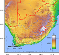
Topographic map of South Africa.
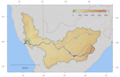
Course and watershed of the Orange River with topography shading and political boundaries.
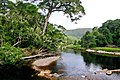
Grootrivier in Nature's Valley, stained a tea colour by plant tannins

Amanzimtoti River at Ilanda Wilds

Amanzimtoti River at Ilanda Wilds

Amanzimtoti Lagoon


See also[]
- List of reservoirs and dams in South Africa
- Water Management Areas
- Estuaries in South Africa
- List of lakes in South Africa
- Lagoons of South Africa
- List of Bays of South Africa
- Drainage basins of South Africa
References[]
- ^ Meiring, Barbara. "South African Toponymic Guidelines for Map and other editors: Fourth Edition"[permanent dead link], 12. Retrieved on 30 April 2013.
- ^ "Maitland River Mouth". Nelson Mandela Bay Tourism. Retrieved 26 June 2019.
External links[]
| Wikimedia Commons has media related to Rivers of South Africa. |
Categories:
- Rivers of South Africa
- Lists of rivers by country
- Lists of landforms of South Africa