Listed buildings in Dalarna County
There are 76 listed buildings (Swedish: byggnadsminne) in Dalarna County.
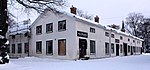
Avesta Municipality[]
placeholder
Borlänge Municipality[]
| Image | Name | Premise | Number of buildings |
Year built | Architect | Coordinates | ID |
|---|---|---|---|---|---|---|---|
|
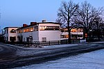
Industriskolan | Utanfors 5 Previously Stg 2948 Forsa 46:3 |
1 | 1931–1932 | Osvald Almqvist | 60°29′31″N 15°26′12″E / 60.49204°N 15.43654°E | 21300000014143 |

|
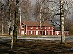
Ornässtugan | Stora Ornäs 1:2 | 4 | 16th century | 60°30′26″N 15°33′10″E / 60.50727°N 15.55283°E | 21300000014366 | |
|
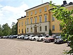
Rommeheds militärläger | Norr Romme 13:6-8 | 33 | 1797–1906 | 60°26′03″N 15°30′04″E / 60.43407°N 15.50108°E | 21300000014306 |
Falun Municipality[]
placeholder
Gagnef Municipality[]
There are no listed buildings in Gagnef Municipality.
Hedemora Municipality[]


Leksand Municipality[]
placeholder
Ludvika Municipality[]
placeholder
Malung-Sälen Municipality[]
placeholder
Mora Municipality[]
placeholder
Orsa Municipality[]
placeholder
Rättvik Municipality[]
placeholder
Smedjebacken Municipality[]
placeholder
Säter Municipality[]
placeholder
Vansbro Municipality[]
placeholder
Älvdalen Municipality[]
placeholder
External links[]
| Wikimedia Commons has media related to Protected buildings in Dalarna County. |
- (in Swedish) Bebyggelseregistret
Categories:
- Listed buildings in Dalarna County