Litlington, East Sussex
| Litlington | |
|---|---|
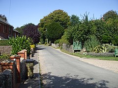 Main street through Litlington and entrance to the Tea Gardens | |
 Litlington Location within East Sussex | |
| Population | 191 Cuckmere Valley as at 2011, including much smaller Westdean and Exceat[1] |
| Civil parish |
|
| District | |
| Shire county | |
| Region | |
| Country | England |
| Sovereign state | United Kingdom |
| Post town | POLEGATE |
| Postcode district | BN26 |
| Dialling code | 01323 |
| Police | Sussex |
| Fire | East Sussex |
| Ambulance | South East Coast |

Litlington is a very lightly populated village in the Cuckmere Valley (which is also its Civil Parish) in England, focussed 3 miles (4.8 km) ENE of Seaford, East Sussex on the south coast. It is in a roughly square parish of dramatic chalkland that extends down to a natural coastline of pebble beach, Cuckmere Haven.
Toponymy[]
The name is Saxon, and literally means Litl's (followers or possibly family's) homestead. It is also potentially a corruption of Littleton but there is no evidence for its missing its -ing component.
Parish description[]
The village is small and like the rest of the parish, which extends to take in much of the Seven Sisters Country Park is on the left bank of a narrow valley in the signature narrow band of the South Downs National Park. It is downriver followed only by marshes mainly to its side of its road leading to hamlets of Exceat and Westdean but across the narrow road a narrow strip of fertile farmland that ascends rapidly into chalkland grazing.
Beyond the Exceat tiny cluster of homes is footpath access to Cuckmere Haven, which has road access from the west, Seaford only, a natural shoreline of pebbles and the soon towering Seven Sisters cliffs to the east. Among features of the landscape here are sheep fields and pillboxes from World War II.
Civic, community buildings and river sports[]
Near the narrow, hedge-lined village street, on its offshoot Clapham Lane, is a community hall, built in 1953.[2]
The church is in the opposite direction, medieval and dedicated to St Michael the Archangel. The Church of England's ecclesiastical parish remains Lilington which has this church and no chapels.[3]
Exceat has a canoe club and a separate paddleboarding experience/outings business.
Notable residents[]
Maria Fitzherbert, mistress of George IV, lived at Clapham House.

Economy[]
Main businesses are a brewery, a crystal and gemstone store, and The Plough & Harrow, a large gastropub-type restaurant.
Litlington White Horse[]
50°47′18″N 0°8′30″E / 50.78833°N 0.14167°E During the 19th century, The Litlington White Horse, being a large chalk figure of a horse was cut into the face of the downs, being situated to the west of the village. The figure, the Litlington White Horse, replaced an earlier period of one present many years before. It is one of the nine white horse figures outside Wiltshire, and was the solution to a treasure hunt in the video game Pimania.[4] North of the parish is the Long Man of Wilmington, famous in part because of its unknown origin.
References[]
External links[]
![]() Media related to Litlington at Wikimedia Commons
Media related to Litlington at Wikimedia Commons
| Authority control |
|
|---|
- Villages in East Sussex
- Wealden