Loch Con
| Loch Con | |
|---|---|
 Fishing hut at Loch Con | |
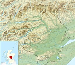
 Loch Con Location in Perth and Kinross | |
| Location | NN68776792 |
| Coordinates | 56°47′04″N 4°09′05″W / 56.784400°N 4.151484°WCoordinates: 56°47′04″N 4°09′05″W / 56.784400°N 4.151484°W |
| Type | freshwater loch |
| Primary outflows | Allt Con |
| Max. length | 1.3 km (0.81 mi) |
| Max. width | 0.4 km (0.25 mi) |
| Surface area | 25 ha (62 acres)[1] |
| Average depth | 3.6 ft (1.1 m)[1] |
| Max. depth | 8.8 ft (2.7 m)[1] |
| Water volume | 9,505,016 cu ft (269,152.1 m3)[1] |
| Shore length1 | 5 km (3.1 mi) [1] |
| Surface elevation | 413 m (1,355 ft)[1] |
| Islands | 0 |
| 1 Shore length is not a well-defined measure. | |
Loch Con is a small, remote, shallow, irregular shaped freshwater loch that is located in in the Perth and Kinross council area, at the edge of the Scottish Highlands.[1][2] It is directly north of Loch Errochty. Directly north of the loch at the east end is . It is the source of the Allt Con, which flows a short distance southwards past Sròn Choin to Loch Errochty.[2] At the north-east end is Loch Cruinn, a very small dam, about 100 metres wide.
See also[]
- List of lochs in Scotland
References[]
- ^ a b c d e f g "Loch Con". Centre for Ecology and Hydrology. Scotland and Northern Ireland Forum for Environmental Research (SNIFFER). Retrieved 8 December 2020.
- ^ a b David M. Munro; Bruce M. Gittings; Royal Scottish Geographical Society (2006). Scotland: An Encyclopedia of Places & Landscapes. Collins. p. 130. ISBN 978-0-00-472466-9. Retrieved 5 March 2021.
Categories:
- Freshwater lochs of Scotland
- Lochs of Perth and Kinross
- Tay catchment
- Birdwatching sites in Scotland
