Loch Iubhair
| Loch Iubhair | |
|---|---|
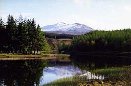 Loch Iubhair Glen Dochart The mountain in the distance is Sgiath Chuil. | |
 Loch Iubhair | |
| Coordinates | 56°24′30″N 4°33′11″W / 56.4083°N 4.553°WCoordinates: 56°24′30″N 4°33′11″W / 56.4083°N 4.553°W |
| Type | freshwater loch |
| Primary outflows | River Dochart |
| Max. length | 2.09215 km (1.30000 mi)[1] |
| Max. width | 0.482 km (0.300 mi)[1] |
| Surface area | 60.7 ha (150 acres)[2] |
| Average depth | 25 ft (7.6 m)[1] |
| Max. depth | 65 ft (20 m)[1] |
| Shore length1 | 7.4 km (4.6 mi) [2] |
| Surface elevation | 152 m (499 ft)[2] |
| 1 Shore length is not a well-defined measure. | |

Loch Iubhair pronounced yoo-ar meaning yew loch,[3] is a freshwater loch, located in Glen Dochart, and 4 miles east of the village of Crianlarich. Loch Dochart is located immediately to the south east, and the outflow of Loch Dochart, as the River Dochart flows into Loch Iubhair.[4][1][2]
References[]
- ^ a b c d e John, Murray; Lawrence, Pullar (1910). Bathymetrical Survey of the Fresh-Water Lochs of Scotland, 1897-1909 Lochs of the Tay Basin Volume II - Loch Iubhair. National Library of Scotland: National Challenger Officer. p. 75. Retrieved 24 July 2018.
 This article incorporates text from this source, which is in the public domain.
- ^ a b c d "Loch Iubhair". British Lakes. Retrieved 24 July 2018.
- ^ "Loch Iubhair & Loch Dochart". Loch Lomond & The Trossachs National Park Authority. Loch Lomond & The Trossachs National Park Authority 2018. Retrieved 15 December 2018.
- ^ "Iubhair, Loch". The Gazetteer for Scotland. School of GeoSciences, University of Edinburgh and The Royal Scottish Geographical Society. Retrieved 24 July 2018.
Categories:
- Freshwater lochs of Scotland
- Tay catchment
- Lochs of Stirling (council area)