Loch Stack
| Loch Stack | |
|---|---|
 Loch Stack | |
 Loch Stack | |
| Location | Sutherland, Scotland |
| Coordinates | 58°20′12″N 4°55′28″W / 58.336700°N 4.924500°W[1] |
| Type | freshwater loch |
| Primary inflows | An Earachd[2] |
| Primary outflows | River Laxford [2] |
| Basin countries | Scotland |
| Max. length | 4 km (2.5 mi)[2] |
| Surface area | 252.1 ha (623 acres)[1] |
| Average depth | 26 m (86 ft)[2] |
| Max. depth | 33 m (108 ft)[2] |
| Water volume | 28,000,000 m3 (988,000,000 cu ft)[2] |
| Shore length1 | 16.6 km (10.3 mi)[1] |
| Surface elevation | 46 m (151 ft)[1] |
| Islands | 1[1] |
| 1 Shore length is not a well-defined measure. | |

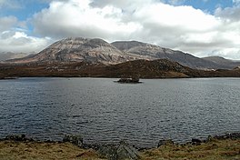
Loch Stack is a large, irregularly shaped freshwater loch in the Northwest of Scotland. It lies approximately 4 miles (6.4 km) southeast of Laxford Bridge and is surrounded by mountains. Ben Stack rises steeply from the loch's southwestern shore and Arkle lies directly to the north.
Survey[]
The loch was surveyed[2] between 6 and 8 September 1902 by T.N. Johnston and James Murray and later charted[3] as part of the Sir John Murray's Bathymetrical Survey of Fresh-Water Lochs of Scotland 1897-1909.
References[]
- ^ a b c d e "Loch Stack". British lakes. British Lakes. Retrieved 6 May 2015.
- ^ a b c d e f g "Bathymetrical Survey of the Fresh-Water Lochs of Scotland, 1897-1909, Lochs of the Laxford Basin". National Library of Scotland. Retrieved 6 May 2015.
- ^ "Loch Stack (Laxford Basin) (Vol. 5, Plate 9) - Bathymetrical Survey, 1897-1909 - National Library of Scotland". National Library of Scotland. Retrieved 6 May 2015.
This Highland location article is a stub. You can help Wikipedia by . |
Categories:
- Landforms of Sutherland
- Freshwater lochs of Scotland
- Highland geography stubs