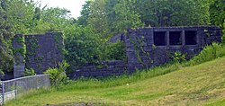
Lock 18 of Enlarged Erie Canal
Lock 18 of Enlarged Erie Canal | |
 West end of lock, 2008 | |
| Location | Cohoes, NY |
|---|---|
| Coordinates | 42°47′05″N 73°42′41″W / 42.78472°N 73.71139°WCoordinates: 42°47′05″N 73°42′41″W / 42.78472°N 73.71139°W |
| Built | 1837-1842[1] |
| Architect | Holmes Hutchinson |
| NRHP reference No. | 71000526 |
| Added to NRHP | 1971 |
Lock 18 of the Enlarged Erie Canal is located off North Mohawk Street in Cohoes, New York, United States. It is made of stone blocks 3 by 2 by 1.5 feet (90 by 50 by 40 cm) in size, roughly 150 feet (46 m) in length, laid in a random ashlar pattern. The lock's wooden gates are no longer extant.
The lock was built as part of an 1837-1842 plan to make the canal bed larger, heading off competition from railroads, and allowing a detour around the section of canal between Albany and Schenectady to the south, which had fewer locks and was difficult to navigate. Holmes Hutchinson, a canal engineer who later became chief of that department and a director of several railroads, surveyed the route and drew up the plans for all locks in the mid-1830s.[1] The canal was relocated slightly within the city of Cohoes; North Mohawk Street today parallels the original alignment, with sections of the original canal kept open to provide water power to nearby mill complexes along the Mohawk River.[2]
Ten of the locks from the Enlarged Erie Canal remain within Cohoes.[3] Lock 18 was individually listed on the National Register of Historic Places, added in 1970 in recognition of the high quality of its remaining stonework; the remainder of the locks on city-owned land were added to the National Register in 2004 as a non-contiguous historic district. A city-owned trail along the former towpath allows visitors to see them. There is also a small parking lot along the street northeast of the lock with an interpretive sign.
References[]
- ^ a b Waite, Diana (July 1970). "National Register of Historic Places nomination, Lock 18 of Enlarged Erie Canal". New York State Office of Parks, Recreation and Historic Preservation. Retrieved 2008-09-09.
- ^ Rossi, Louis; "History/Mystery Bike Tour: Erie and Champlain Canals in Cohoes and Waterford" (PDF). Archived from the original (PDF) on 2010-08-27., retrieved September 9, 2008.
- ^ "Mill District" (PDF). Archived from the original (PDF) on 2010-08-27., Spindle City Historic Society, Mohawk Towpath Scenic Byway website, retrieved September 9, 2008.
External links[]
- Pictures of Lock 18 at Tug44.org
- Erie Canal parks, trails, and historic sites
- Locks on the National Register of Historic Places in New York (state)
- Cohoes, New York
- Transportation buildings and structures in Albany County, New York
- Tourist attractions in Albany County, New York
- Transport infrastructure completed in 1842
- National Register of Historic Places in Albany County, New York


