Lom (river)
| Lom | |
|---|---|
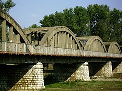 The Italian-built bridge over the Lom at Kriva Bara | |
| Location | |
| Country | Bulgaria |
| Physical characteristics | |
| Mouth | |
• location | Danube |
• coordinates | 43°50′16″N 23°14′57″E / 43.8377°N 23.2493°ECoordinates: 43°50′16″N 23°14′57″E / 43.8377°N 23.2493°E |
| Length | 92.5 km (57.5 mi)[1] |
| Basin size | 1,160 km2 (450 sq mi)[1] |
| Basin features | |
| Progression | Danube→ Black Sea |

The Lom (Bulgarian: Лом [ˈɫɔm], Latin: Almus) is a river in northwestern Bulgaria, a right tributary of the Danube flowing into it 1 km east of the town of Lom.
The river takes its source from the foot of Midzhur (2,168 m), the highest peak of western Stara Planina, on the Bulgarian-Serbian border, and mainly flows northeast until its upper course, where it heads north. It passes the villages of Gorni Lom, Dolni Lom, Sredogriv, , Ruzhintsi, , Belo Pole, , Drenovets, , Knyazheva Mahala, Kriva Bara, Vasilovtsi, Staliyska Mahala, Traykovo, as well as three quarters of the town of Lom: Momin Brod, Dalgoshevtsi and Golintsi.
References[]
Categories:
- Tributaries of the Danube
- Rivers of Bulgaria
- Landforms of Vidin Province
- Landforms of Montana Province
- Europe river stubs
- Bulgaria geography stubs