Longleng
Longleng | |
|---|---|
 Longleng Location in Nagaland, India | |
| Coordinates: 26°28′07″N 94°48′33″E / 26.4685°N 94.8092°ECoordinates: 26°28′07″N 94°48′33″E / 26.4685°N 94.8092°E | |
| Country | |
| State | |
| District | Longleng |
| Elevation | 1,066 m (3,497 ft) |
| Population (2011)[1] | |
| • Total | 7,613 |
| Languages | |
| • Official | English |
| Time zone | UTC+5:30 (IST) |
| Vehicle registration | NL |
| Website | nagaland |

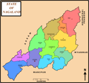
District map of Nagaland with Longleng town
Longleng (Pron:/ˈlɒŋˌlɛŋ/) situated at an altitude of 1066 metres above sea level in India. It the district headquarters of the newly formed Longleng district in Nagaland[2] and has a population of 7,613.[1] The town is inhabited by the Phom Nagas with Phom as the main dialect spoken by the people.
External links[]
References[]
- ^ a b "Longleng City Population Census 2011 - Nagaland". www.census2011.co.in.
- ^ "Longleng District in India". www.india9.com.
Categories:
- Cities and towns in Longleng district