Lontor
Native name: Banda Besar | |
|---|---|
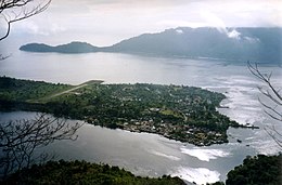 Banda Neira and Lontor from Banda Api | |
 Map of Banda Islands | |
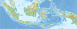 Lontor Location in Indonesia | |
| Geography | |
| Location | Banda Sea |
| Coordinates | 4°33′S 129°55′E / 4.550°S 129.917°E |
| Archipelago | Banda Islands |
| Area | 26.37 km2 (10.18 sq mi) |
| Length | 12 km (7.5 mi) |
| Width | 3 km (1.9 mi) |


Lontor, also known as Lonthor or Lonthoir, or locally Banda Besar ("Great Banda", or Groot-Banda in Dutch), is an island in the Banda Islands, Indonesia.[1] It is administered as part of the administrative district (kecamatan) within the Central Maluku Regency in the province of Maluku.
Geography[]
Lontor is one of the three central Banda Islands: Banda Neira is 800 meters to the north and Banda Api volcano island is 1 km away. The small islet of Pualu Kraka is 1 kilometer north. Lontor and Pula Kraka are located on the south and east sides of submerged caldera with a diameter of around seven kilometers, inside which are the islands of Banda Neira and Banda Api.
Lontor has length of 12 kilometres (7.5 mi) and width of 3 kilometres (1.9 mi) and is the largest of the Banda Islands. The entire island is crossed by a chain of hills and small mountains with a maximum height of 536 metres (1,759 ft). The largest settlements are Lonthoir, Selamon and Waer. There are two dilapidated Dutch forts: Lonthoir Benteng Hollandia, Waer Benteng Concordia.
History[]
Nutmeg is grown on the island and trade brought the inhabitants great wealth in the premodern period. Until the early 17th century, the Banda Islands were ruled by locals magnates called the Orang Kaya. The Portuguese were the first Europeans to attempt to dominate the spice trade from the 16th century, but were replaced by the Dutch. Initially, the Dutch established friendly relations and a trading outpost in 1599,[2] but in 1609 the Orang Kaya on Banda Neira rebelled against Dutch attempts to coerce a monopoly on the spice trade, killing 30 Netherlanders.[3] This resulted in a brutal campaign against the people of Banda Islands by the Dutch including two punitive military expeditions in early 1611 against Lontor led by Piet Hein. The Dutch conquest of the Banda Islands cumulated with the Banda Massacre of 1621, in which Jan Pieterszoon Coen, with a fleet of 19 ships, 1,655 European troops and 286 Asian auxiliaries, invaded the islands and subsequently began a campaign to commit genocide against the local inhabitants.[4] According to Coen's own account, "about 2,500" inhabitants died "of hunger and misery or by the sword", "a good party of woman and children" were taken, and not more than 300 escaped.[5] Straver (2018) concluded that the Lontorese population would have been around 4,500–5,000 people, 50 to 100 of whom died during the fighting, 1,700 of whom were enslaved and 2,500 of whom died due to famine and disease, while an unknown number of natives jumped to their deaths from the cliffs; several hundreds escaped to nearby islands such as the Kei Islands and eastern Seram.
To keep the archipelago productive, the VOC repopulated the islands (including Lontor), mostly with slaves taken from the rest of modern-day Indonesia, India, the coast of China, working under command of Dutch planters (perkeniers).[6] The original natives were also enslaved and were ordered to teach the newcomers about nutmeg and mace agriculture.[7] The treatment of the slaves was severe—the native Bandanese population dropped to one hundred by 1681, and 200 slaves were imported annually to keep the slave population steady at 4,000.[7]
The Dutch continued to rule the island until 1949, although the economic importance of nutmeg and mace declined greatly due to the loss of the Dutch monopoly after the British successfully planted nutmeg trees in other parts of the world (especially Penang and Grenada) following the Invasion of the Spice Islands in the Napoleonic Wars in 1810. Following Indonesian independence, the island has been administered as part of the Indonesian province of Maluku.
See also[]
| Wikimedia Commons has media related to Banda Besar. |
References[]
- ^ Cribb, Robert (2013-02-01). Historical Atlas of Indonesia. Routledge. p. 109. ISBN 9781136780578.
- ^ Schendel, Arthur van (1983-01-01). John Company. Univ of Massachusetts Press. p. 189. ISBN 0870233831.
- ^ Kahler, H. (1981-12-31). Modern Times. Brill Archive. p. 272. ISBN 9004061967.
- ^ Taylor, Jean Gelman (2003-01-01). Indonesia: Peoples and Histories. Yale University Press. p. 165. ISBN 0300105185.
- ^ Corn 1998, p. 170.
- ^ Loth 1995, p. 24.
- ^ Jump up to: a b Van Zanden 1993, p. 77.
External links[]
- Banda Islands
- Central Maluku Regency