Lutterveld
Lutterveld | |
|---|---|
Hamlet | |
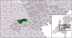 | |
 Lutterveld in the municipality of Buren. | |
| Coordinates: 51°53′55″N 5°21′09″E / 51.89861°N 5.35250°ECoordinates: 51°53′55″N 5°21′09″E / 51.89861°N 5.35250°E | |
| Country | Netherlands |
| Province | Gelderland |
| Municipality | Buren |
| Time zone | UTC+1 (CET) |
| • Summer (DST) | UTC+2 (CEST) |
| Postal code | 7777 |

Lutterveld is a hamlet in the Dutch province of Gelderland. It is a part of the municipality of Buren, and lies about 4 km west of Tiel.[1]
References[]
- ^ ANWB Topografische Atlas Nederland, Topografische Dienst and ANWB, 2005.
This Gelderland location article is a stub. You can help Wikipedia by . |
Categories:
- Populated places in Gelderland
- Buren
- Gelderland geography stubs