Luyères
This article may be expanded with text translated from the corresponding article in French. (December 2008) Click [show] for important translation instructions.
|
Luyères | |
|---|---|
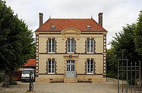
 The town hall in Luyères | |
Location of Luyères  | |
 Luyères | |
| Coordinates: 48°22′59″N 4°11′44″E / 48.3831°N 4.1956°ECoordinates: 48°22′59″N 4°11′44″E / 48.3831°N 4.1956°E | |
| Country | France |
| Region | Grand Est |
| Department | Aube |
| Arrondissement | Troyes |
| Canton | Arcis-sur-Aube |
| Intercommunality | Forêts, lacs, terres en Champagne |
| Government | |
| • Mayor (2020–2026) | Alain Carre |
| Area 1 | 17.37 km2 (6.71 sq mi) |
| Population (Jan. 2018)[1] | 454 |
| • Density | 26/km2 (68/sq mi) |
| Time zone | UTC+01:00 (CET) |
| • Summer (DST) | UTC+02:00 (CEST) |
| INSEE/Postal code | 10210 /10150 |
| 1 French Land Register data, which excludes lakes, ponds, glaciers > 1 km2 (0.386 sq mi or 247 acres) and river estuaries. | |


Luyères (French pronunciation: [lɥijɛʁ]) is a commune in the Aube department in north-central France.
Population[]
| Year | Pop. | ±% |
|---|---|---|
| 1962 | 187 | — |
| 1968 | 227 | +21.4% |
| 1975 | 383 | +68.7% |
| 1982 | 383 | +0.0% |
| 1990 | 401 | +4.7% |
| 1999 | 382 | −4.7% |
| 2008 | 437 | +14.4% |
Town hall (mairie) of Luyères
See also[]
References[]
- ^ "Populations légales 2018". The National Institute of Statistics and Economic Studies. 28 December 2020.
| Wikimedia Commons has media related to Luyères. |
This Aube geographical article is a stub. You can help Wikipedia by . |
Categories:
- Communes of Aube
- Aube geography stubs