Lykketoppen
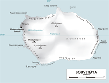
Map of Bouvetøya
Lykketoppen,[1][2] occasionally anglicized as Lykke Peak, is a snow-covered, 765-meter (2,510 ft) tall summit that surmounts the southwest part of Bouvetøya, standing 1 nautical mile (2 km) east of Norvegia Point. It was first roughly charted in 1898 by a German expedition under Carl Chun, and was recharted and named in December 1927 by the under Captain .[3]
References[]
- ^ "Lykketoppen". Norwegian Polar Institute. Archived from the original on 12 May 2012. Retrieved 11 May 2012.
- ^ Barr, Susan (1987). Norway's Polar Territories. Oslo: Aschehoug. p. 59. ISBN 82-03-15689-4.
- ^ "Lykke Peak". Geographic Names Information System. Archived from the original on 12 May 2012. Retrieved 12 May 2012.
Coordinates: 54°27′S 3°23′E / 54.450°S 3.383°E

![]() This article incorporates public domain material from the United States Geological Survey document: "Lykke Peak". (content from the Geographic Names Information System)
This article incorporates public domain material from the United States Geological Survey document: "Lykke Peak". (content from the Geographic Names Information System)
This Bouvet Island location article is a stub. You can help Wikipedia by . |
Categories:
- Mountains of Bouvet Island
- Norway geography stubs
- Subantarctic island geography stubs