Mülheim, Cologne
Mülheim | |
|---|---|
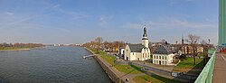 Panoramic view of Mülheim as seen from Mülheimer Brücke | |
 Coat of arms | |
 Location of Mülheim shown in red | |
| Country | Germany |
| Federal state | North Rhine-Westphalia |
| City | Cologne |
| Area | |
| • Total | 52.2 km2 (20.2 sq mi) |
| Population (December 2009) | |
| • Total | 144,419 |
| • Density | 2,765/km2 (7,160/sq mi) |

Mülheim (German: Köln-Mülheim [ˈmyːlhaɪm]; Kölsch: Möllem [ˈmølːəm]) is a city district (Stadtbezirk) of Cologne in Germany and a formerly independent town (Mülheim am Rhein). Mülheim is located on the right bank of the Rhine opposite the old town of Cologne.
The district borders Leverkusen to the north, Bergisch Gladbach to the east, the Cologne districts of Kalk and Innenstadt to the south. The river Rhine lies west of Mülheim, on the other riverbank lies the Cologne borough of Nippes.
The district is ethnically diverse, with a significant Turkish population.
History[]
The place was first mentioned (as Mulenheym) in 1098[1] and became a town in 1322; it belonged to the County of Berg. In April 1914, Mülheim was incorporated into Cologne.
Subdivisions[]
Mülheim consists of nine Stadtteile (city parts):
| # | City part | Population (2009) | Area (km2) | Pop. per km2 | map |
|---|---|---|---|---|---|
| 901 | 41,021 | 7,07 | 5,805 | ||
| 902 | Buchforst | 7,273 | 0,83 | 8,757 | |
| 903 | Buchheim | 12,411 | 2,86 | 4,345 | |
| 904 | Holweide | 20,747 | 4,11 | 5,045 | |
| 905 | Dellbrück | 21,345 | 9,95 | 2,145 | |
| 906 | Höhenhaus | 14,778 | 5,08 | 2,911 | |
| 907 | Dünnwald | 11,685 | 10,9 | 1,077 | |
| 908 | Stammheim | 7,359 | 3,75 | 1,965 | |
| 909 | Flittard | 7,800 | 7,74 | 1,008 | |
| source: Die Kölner Stadtteile in Zahlen 2010 (in German) | |||||
Transportation[]
Mülheim is served by numerous railway stations and highway. Train stations include Köln-Mülheim, Köln-Buchforst, Köln-Dellbrück and Köln-Stammheim, as well as numerous light rail stations of Cologne Stadtbahn line 3, 4, 13 and 18. Bundesautobahn 3 passes through Dellbrück and Dünnwald, as part of the Cologne Beltway.
Rhine bridges[]
Notable people[]
- Adam Adami, Roman Catholic diplomat and priest (1610–1663)
- Abraham Roentgen, cabinet maker (1711–1793)
- Herbert Eulenberg, poet and author (1876–1949)
- Catharina Josepha Pratten, guitarist and composer (1821–1895)
- , rector and historian (1863–1947)
- Peter Kürten, serial killer (1883–1931)
- Willi Ostermann, singer and poet (1876–1936)
- , Jesuit and exorcist (1894–1989)
- Rainer Woelki, Archbishop of Cologne (*1956)
References[]
External links[]
| Wikimedia Commons has media related to Köln-Mülheim. |
- . Encyclopædia Britannica. 18 (11th ed.). 1911. p. 960.
- Official webpage of the district (in German)
| hide | ||
|---|---|---|
| ||
Coordinates: 50°58′N 7°01′E / 50.967°N 7.017°E

This Cologne location article is a stub. You can help Wikipedia by . |
- Mülheim, Cologne
- Boroughs and quarters of Cologne
- 1098 establishments in Europe
- Cologne region geography stubs