Mūša
| Mūša, Mūsa | |
|---|---|
 Map highlighting Mūša | |
| Location | |
| Country | Lithuania and Latvia |
| Physical characteristics | |
| Source | |
| • location | Joniškis district |
| Mouth | Lielupe |
• location | Bauska |
• coordinates | 56°24′10″N 24°9′34″E / 56.40278°N 24.15944°ECoordinates: 56°24′10″N 24°9′34″E / 56.40278°N 24.15944°E |
| Length | 164 km (102 mi) |
| Basin size | 5,318 km2 (2,053 sq mi) |
| Basin features | |
| Progression | Lielupe→ Baltic Sea |
| Tributaries | |
| • right | Kruoja, Lėvuo, Pyvesa, Tatula |

Mūša (Latvian: Mūsa; German: Muhsse) is a river in Northern Lithuania and Southern Latvia (Zemgale region). At its confluence with the river Nemunėlis (Latvian: Mēmele) in Latvia, near city Bauska, the river Lielupė is formed. The river is 164 kilometers (146 km in Lithuania, 18 km in Latvia) long.
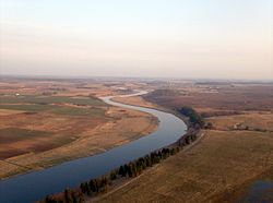
Mūša in Pasvalys district, Lithuania

Hängebrücke-Musa-Bauska
References[]
- LIETUVOS RESPUBLIKOS UPIŲ IR TVENKINIŲ KLASIFIKATORIUS (Republic of Lithuania- River and Pond Classifications). Ministry of Environment (Lithuania). Accessed 2011-11-17.
This Semigallia location article is a stub. You can help Wikipedia by . |
Categories:
- Tributaries of the Lielupe
- Rivers of Lithuania
- Rivers of Latvia
- International rivers of Europe
- Latvia–Lithuania border
- Lithuania river stubs
- Zemgale geography stubs
- Europe river stubs
- Latvia geography stubs