Madhugiri
This article needs additional citations for verification. (May 2014) |
Madhugiri | |
|---|---|
city | |
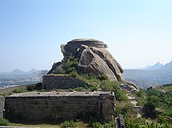 Madhugiri Fort | |
 Madhugiri Location in Karnataka, India | |
| Coordinates: 13°40′N 77°13′E / 13.66°N 77.21°ECoordinates: 13°40′N 77°13′E / 13.66°N 77.21°E | |
| Country | |
| State | Karnataka |
| District | Tumakuru[1] |
| Government | |
| • Type | municipal council |
| Elevation | 787 m (2,582 ft) |
| Population (2001) | |
| • Total | 267,866 |
| Languages | |
| • Official | Kannada |
| Time zone | UTC+5:30 (IST) |
| PIN | |
| Vehicle registration | KA-64 |

Madhugiri is a city in Tumkur district in the Indian state of Karnataka. The city derives its name from a hillock, Madhu-giri (honey-hill) which is to the south of the place. Madhugiri is one of the 34 educational districts of the Karnataka state.[2] Madhugiri surrounding taluks public is demanding to separate madhugiri district out from TUMKUR district since 25 years
At 3,930 ft (1,200 m) elevation, Madhugiri is a single hill. Nestled on its steep slopes is a fort. Antaralada Bagilu, Diddi Bagilu, and Mysuru Gate are the three gateways of the fort. A series of doorways leads to the hill. The ruined temple of Gopalakrishna is located at the top.
The construction of the original mud fort was undertaken by Raja Hire Gowda in the 17th century around 1670 AD. An interesting incident prompted the Gowda family to consider building a fortress. A stray sheep went missing around the Madhugiri hillock only to return late in the night dripping with water. This was music to the ears since a spring would definitely be welcome sign for rain deficient area. A decision to construct a fortress was arrived and the task was completed. The Gowdas started ruling this region based at Madhugiri Fort.
Genesis of the name Madhugiri is derived from the Honeybee colonies which were prevalent in those days towards the northern parts of the Madhugiri fortress. There are several historical temples in and around Madhugiri. However three of them are the main ones that draw regular devotees - the Sri Venkatramana Swamy, the nearby Sri Malleswara Swamy temple and the Dandina Maramma temple at the entrance of the town while coming from Bangalore/Tumkur. There is also a Jaina temple on the precincts of the Madhugiri fort.
Madhugiri, once known as Maddagiri over a hundred years ago, is located around 43 km north of Tumkuru town, and 100 km north-west of Bengaluru city. The monolith and the surrounding greenery of Madhugiri are the main attractions. The place has the old temples of Venkataramanaswami and Malleshwara built by the Vijayanagara feudatories in the Dravidian style.
The highlight is the rock dome, atop which stands a fort. There are a series of doorways leading to the top and the climb is steep and exposed in some places. On the top is the ruined Gopalakrishna temple. [3] The difficulty level is moderate to difficult and take around 4 hours for the ascent.[4]
Attractions[]
- Jayamangali Blackbuck Reserve also known as Maidana Halli Blackbuck Sanctuary is 25 km from Madhugiri. It is near Kodigenahalli, one of the prominent hobli of Madhugiri. Prior permission for overnight camping inside the reserve is needed.
- Chennarayana Durga, located 10 km from Koratagere on the way to Madhugiri via Tumkur, is one of the nine Durga forts. Inside the fort, there is a small temple and semi-ruined old structures can be explored.
- Siddara Betta is known for its medicinal herbs. A natural spring that gushes out from the top of the hill is believed to have medicinal value.
- Madhugiri Fort was built by the Vijaynagar dynasty. Jain Temples are also found at this place.
- Madhugiri State Forest, also known as Timmalapura Forest is close to Madhugiri. The forest is known for its population of peafowls and sloth bears.
- Temples dedicated to Venkataramana and Malleshvara stand side by side in the town. They face east and are built in the Dravidian style of architecture with lofty towers. Venkataramana temple is said to have been built by the chief Nagi Reddy. But the garbhagriha appears to be of Hoysala times. There is a statue near the southern door of the prakara, described as of Nagi Reddy.
- Historical Sree Harihareshwara Swamy Temple (East Faced) Built A.D 979 (Shalivaahana Shaka.900) by Badaganaadu Brahmana Karinika Kariappa and help of his friends. temple located south of town towards Tumakuru in the state highway right and side around 3 km. with Naturally and attractive sculpture of swamy.
- Basvangi Kaval Fort (Kithagali village) and Channarayana Durga. Fort is around 20 km from Madhugiri both hills famous for trekking
- Dandina Maramman Temple Best time to visit the temple is during Jathra Mohothsava & Yugadi festival as it is most crowded during that festival. Regular timings of the temple are 6:00 AM – 9:00 PM on all week days, prefers days are Tuesday and Friday and also Amavasya & Hunime.
Other features[]

- The Mallinatha Jaina Basadi adjoining the fort wall has a good manasthamba.
- At the Veerashaiva Gurrammana Matha there is a tomb of a guru named Shivalingaswamy. There are some fine caves near the matha.
- The erection of the fort at Madhugiri is ascribed to a local chief named Raja Hire Gowda. The fort was greatly improved by Haidar Ali. Haidar Ali, after the conquest of Bednur, had kept the Rani of Bednur imprisoned in this fort until its capture by the Marathas in 1767 A.D.
- Several gates such as the Antaralada Bagilu, Diddibagilu and the Mysore Gate lead one to the top of the hill which has many springs.
- The place is known for the manufacture of handloom cloth and blankets. A superior variety of rice called chinnada-salakki (golden stick) is grown in this taluk.
- Midugeshi, the headquarters of the hobli of the same name, is about 19 km north of the Madhugiri town. The place is said to have been so named by a local chief Nage Gowda of Vijayanagara times, after his wife Midugeshi who was called because her locks (Kesha) were so long that it touched her feet.
- The Midugeshi hill is said to have been fortified by Nage Gowda and it has several gates leading to the top of the hill. On a rock beside the steps to the hill, there is the statue of the woman in relief, and it is identified as of a heroic woman called Chikkamallamma. On the hill are granaries, dome-like structures for storing ghee and oil, powder magazines and springs which are called Musare-done and Kanneramana-done. On the summit is a mosque with two minarets at the sides and ornamental parapet all round roof. Close to the mosque there is a shrine of Hanuman. The building has flights of steps on both the sides.
(Source: Karnataka State Gazetteer 1983)

Geography[]
Madhugiri is located at 13°40′N 77°13′E / 13.66°N 77.21°E.[6] It has an average elevation of 787 metres (2582 feet).
Demographics[]
As of 2001 India census,[7] Madhugiri had a population of 26,351. Males constitute 52% of the population and females 48%. Madhugiri has an average literacy rate of 72%, higher than the national average of 59.5%: male literacy is 77%, and female literacy is 67%. In Madhugiri, 11% of the population is under 6 years of age.
Agriculture[]
The prime crops that are grown in Madhugiri are groundnut, ragi and mango, sericulture, coconut and Kakada (flower). It is known for pomegranate fruit ('daalimbe' in Kannada).[8]
Transportation[]
Nearest Railway Station is Tumakuru Jn. around 44 km. From Bengaluru there are many ways to reach Madhugiri:
- via Nelamangala, Dabaspete (in Dabaspete take a right turn), Urdigere, Koratagere to Madhugiri (102 km). For this route there is a KSRTC bus every 25 min (Morning 5am to evening 9pm) from Bengaluru (Majestic).
- via Tumkur, Koratagere to Madhugiri (114 km).
From Tumkur, there are two ways to reach Madhugiri:
- on leaving Tumkur, there is a deviation that goes via Siddhara Betta and Chennarayana Durga to Madhugiri,
- the other deviation goes directly to Madhugiri via Koratagere.
- From Bengaluru via Doddaballapur, Hindupura also can reach Madhugiri.
See also[]
- Tumkur District
- Taluks of Karnataka
References[]
- ^ "Bangalore is now Bengaluru". November 2014.
- ^ http://ssakarnataka.gov.in/pdfs/aboutus/edn_profile_state.pdf
- ^ "Madhugiri Pincode". citypincode.in. Retrieved 19 May 2014.
- ^ Madhugiri Trek blog. sakrecubes travel blogs.
- ^ "Bird's Eye View of Maddagiri, A Flat-Roofed Town in Mysore". Chronicles of the London Missionary Society. 1890. Retrieved 2 November 2015.
- ^ Madhugiri. Fallingrain.com. Retrieved on 2012-09-04.
- ^ "Census of India 2001: Data from the 2001 Census, including cities, villages and towns (Provisional)". Census Commission of India. Archived from the original on 16 June 2004. Retrieved 1 November 2008.
- ^ "TUMKUR DISTRICT TOURIST PLACES".
| Wikimedia Commons has media related to Madhugiri. |
- Cities and towns in Tumkur district
- Forts in Karnataka
- Buildings and structures in Tumkur district