Magdalena, Intibucá
This article has multiple issues. Please help or discuss these issues on the talk page. (Learn how and when to remove these template messages)
|
Magdalena | |
|---|---|
 Church in Magdalena | |
|
Seal | |
 Magdalena Location in Honduras | |
| Coordinates: 13°56′02.60″N 88°22′36.70″W / 13.9340556°N 88.3768611°W | |
| Country | Honduras |
| Department | Intibucá |
| Municipality | Magdalena |
| Foundation | 1822 |
| Government | |
| • Mayor | Gustavo Adolfo del Cid |
| Area | |
| • Total | 41.61 km2 (16.07 sq mi) |
| Elevation | 300 m (1,000 ft) |
| Population (2015) | |
| • Total | 4,422 |
| • Density | 110/km2 (280/sq mi) |
| Time zone | UTCGMT-6 |
| Postal Code | 14000 |
| Municipality number | 1008 |

Magdalena (Spanish pronunciation: [maɣðaˈlena]) is a municipality in the Honduran department of Intibucá. Magdalena is located 86 km south of the city of La Esperanza and 280 km west of Tegucigalpa. The municipality consists of 7 villages and 33 hamlets.
History[]
It cannot be said with certainty who the first settlers of Magdalena were, where they came from, and when they established the settlement; indigenous towns of Camasca and Colomoncagua already existed there in the late 17th century. According to Hector P. Nolasco, the most experienced historian in history of the municipality, it appears that the site which currently in Magdalena previously consisted of estates that belonged to part of Camasca where they broke up to form a new municipality. It is known from documents prior to the municipality's foundation that at the beginning of the 18th century it was measured and titled the "Hacienda de la Magdalena", measuring seven cavalries, and was re-measured on 7 July 1740 on the request of Marcos Díaz, Native Indian Chief of Camasca.
According to a leaflet edited by the notable professor Maria Trinidad del Cid, the municipality of Magdalena was founded on 15 October 1821; she claimed this as Florentín del Cid, her grandfather, held the position of municipal secretary for several years of the 19th century and the beginning of the 20th century, since in these years the municipal file had not suffered ruin and they were finding in many significant historical documents. However, according to other opposing information later it was known that the date of creation was on 26 October 1861. This municipality was formed bu the union of the estates La Magdalena, San Blas, La Trinidad, La Caridad, part of the estates La Negra Vieja, San Pablo Tenamera, and the hamlet of San Juan Troncoso.
The constitutional mayor and chief of Camasca district joined this population on 21 June 1843 who proceeded to create paths and milestones of the demarcation of the municipality of Magdalena.
This municipality was separate from Camasca, and Magdalena municipality, which was lacking common land for its inhabitants to freely cultivate, requested the supreme government to hand over a part of Camasca municipality's common land to increase its territory. In 1870, the president of the republic was General José María Medina and governor of the department of Gracias, which this municipality belonged to, was Rosa Muñoz. The supreme government in view of the request of Magdalena's people (village), sent the land surveyor Juan Bautista Collart, in order that of Camasca's common lands measuring five cavalries of area those that passed to be common lands of this municipality. The measurement took place on 14 to 18 October 1870. The drawers of rope (string) were Doroteo and Teodosio Ramos, witnesses Valentín Días y Olayo Claros, neighbors of Santa Lucía, book-keepers were Francisco Rodríguez and Genaro Juárez, of this neighborhood. The rope (string) that was used measured 50 Spanish rods (42 m). At present, with the use of modern measuring devices and techniques, it is known that the municipality measures 41.46 km2 (16.01 sq mi).
Geography[]
This section is empty. You can help by . (February 2021) |
Political divisions[]
Neighborhoods[]
- El Castaño
- La Cultura
- El Centro
- El Recibimiento
- Barrio Abajo
- El Llano
- Buenos Aires
Capital: La Esperanza | ||
| Municipalities | 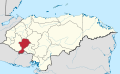 | |
Coordinates: 13°55′59.61″N 88°22′32.26″W / 13.9332250°N 88.3756278°W
- Populated places in Honduras
- 1861 establishments in Honduras