Maidbronn
This article does not cite any sources. (October 2013) |
show This article may be expanded with text translated from the corresponding article in German. (October 2013) Click [show] for important translation instructions. |
Maidbronn | |
|---|---|
Ortsteil of Rimpar | |
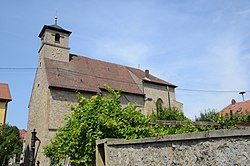 Church of Saint Afra | |
show Location of Maidbronn | |
 Maidbronn | |
| Coordinates: 49°50′49″N 09°58′16″E / 49.84694°N 9.97111°ECoordinates: 49°50′49″N 09°58′16″E / 49.84694°N 9.97111°E | |
| Country | Germany |
| State | Bavaria |
| Admin. region | Unterfranken |
| District | Würzburg |
| Municipality | Rimpar |
| Elevation | 245 m (804 ft) |
| Population (2012-12-31) | |
| • Total | 1,032 |
| Time zone | UTC+01:00 (CET) |
| • Summer (DST) | UTC+02:00 (CEST) |
| Postal codes | 97222 |
| Dialling codes | 09365 |
| Vehicle registration | WÜ |


Maidbronn is a village in Bavaria, Germany, located about 7 kilometres (4.3 mi) northeast of Würzburg. It is part of the municipality Rimpar.
It was the location of the former Maidbronn Abbey, the church of which is still in use by the parish.
| Authority control |
|---|
This Würzburg district location article is a stub. You can help Wikipedia by . |
Categories:
- Würzburg (district)
- Lower Franconia geography stubs