Makato
Makato
Taft | |
|---|---|
| Municipality of Makato | |
 | |
 Flag  Seal | |
| Nickname(s): Blooming Makato | |
| Motto(s): Hala Bira sa Progreso | |
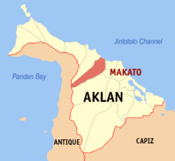 Map of Aklan with Makato highlighted | |
OpenStreetMap  | |
 Makato Location within the Philippines | |
| Coordinates: 11°42′43″N 122°17′32″E / 11.712°N 122.2922°ECoordinates: 11°42′43″N 122°17′32″E / 11.712°N 122.2922°E | |
| Country | Philippines |
| Region | Western Visayas |
| Province | Aklan |
| District | 2nd district |
| Barangays | 18 (see Barangays) |
| Government | |
| • Type | Sangguniang Bayan |
| • Mayor | Abencio T. Torres |
| • Vice Mayor | Ramon Anselmo Martin D. Legaspi III |
| • Representative | Teodorico T. Haresco Jr. |
| • Municipal Council | Members |
| • Electorate | 20,063 voters (2019) |
| Area | |
| • Total | 64.60 km2 (24.94 sq mi) |
| Elevation | 52 m (171 ft) |
| Highest elevation | 1,070 m (3,510 ft) |
| Lowest elevation | 0 m (0 ft) |
| Population (2020 census) [3] | |
| • Total | 29,717 |
| • Density | 460/km2 (1,200/sq mi) |
| • Households | 6,538 |
| Economy | |
| • Income class | 4th municipal income class |
| • Poverty incidence | 20.08% (2015)[4] |
| • Revenue | |
| • Appropriations | |
| • Assets | |
| • Liabilities | |
| • Expenditure | |
| • Obligation's | |
| Service provider | |
| • Electricity | Aklan Electric Cooperative (AKELCO) |
| Time zone | UTC+8 (PST) |
| ZIP code | 5611 |
| PSGC | |
| IDD : area code | +63 (0)36 |
| Native languages | Aklan Hiligaynon Tagalog |
| Patron saint | Sto. Nino |
| Website | www |

Makato, officially the Municipality of Makato (Aklanon: Banwa it Makato; Hiligaynon: Banwa sang Makato; Tagalog: Bayan ng Makato), is a 4th class municipality in the province of Aklan, Philippines. According to the 2020 census, it has a population of 29,717 people. [3]
Established in the thirteenth century, the town’s name had been acquired by accident. Thinking that the Spaniards came to ask the route along the river, the native answered “Makato” which meant “that way”. The Spaniards recorded the name Makato on the year Eighteen Hundred (1800) thinking it was the name of the town. In 1901, the town merged with Tangalan to form the new municipality of Taft, named after the then United States President, William Howard Taft. But in 1923, Respresentative Manuel Terencio of Capiz, authored a law restoring its former name. In 1948, the arrabal of Tangalan, comprising the barrios of Tondog, Jawili, Dumatad, Afga, Baybay, Dapdap, Pudyot, Tagas, Tamalagon, Panayakan, Vivo, Lanipga, Napatag and Tamoko, was separated from Makato to form the municipality of Tangalan.[11]
Geography[]
Makato is located at 11°42′43″N 122°17′32″E / 11.712°N 122.2922°E. It is 8 kilometres (5.0 mi) from Kalibo, the provincial capital.
According to the Philippine Statistics Authority, the municipality has a land area of 64.60 square kilometres (24.94 sq mi) [12] constituting 3.55% of the 1,821.42-square-kilometre- (703.25 sq mi) total area of Aklan.
Climate[]
| Climate data for Makato, Aklan | |||||||||||||
|---|---|---|---|---|---|---|---|---|---|---|---|---|---|
| Month | Jan | Feb | Mar | Apr | May | Jun | Jul | Aug | Sep | Oct | Nov | Dec | Year |
| Average high °C (°F) | 28 (82) |
29 (84) |
30 (86) |
32 (90) |
32 (90) |
31 (88) |
30 (86) |
30 (86) |
29 (84) |
29 (84) |
29 (84) |
28 (82) |
30 (86) |
| Average low °C (°F) | 23 (73) |
22 (72) |
23 (73) |
24 (75) |
25 (77) |
25 (77) |
25 (77) |
24 (75) |
25 (77) |
24 (75) |
24 (75) |
23 (73) |
24 (75) |
| Average precipitation mm (inches) | 47 (1.9) |
33 (1.3) |
39 (1.5) |
48 (1.9) |
98 (3.9) |
150 (5.9) |
169 (6.7) |
147 (5.8) |
163 (6.4) |
172 (6.8) |
118 (4.6) |
80 (3.1) |
1,264 (49.8) |
| Average rainy days | 11.4 | 8.2 | 9.3 | 9.7 | 19.1 | 25.6 | 27.4 | 25.5 | 25.5 | 25.2 | 18.5 | 14.5 | 219.9 |
| Source: Meteoblue [13] | |||||||||||||
Barangays[]
Makato is politically subdivided into 18 barangays.[14]
| PSGC | Barangay | Population | ±% p.a. | |||
|---|---|---|---|---|---|---|
| 2020 [3] | 2010 [15] | |||||
| 060411001 | Agbalogo | 3.8% | 1,127 | 990 | 1.34% | |
| 060411002 | Aglucay | 1.9% | 557 | 521 | 0.69% | |
| 060411003 | Alibagon | 2.2% | 641 | 543 | 1.72% | |
| 060411004 | Bagong Barrio | 1.6% | 487 | 429 | 1.31% | |
| 060411005 | Baybay | 7.0% | 2,077 | 1,916 | 0.83% | |
| 060411006 | Cabatanga | 4.2% | 1,246 | 1,144 | 0.88% | |
| 060411007 | Cajilo | 4.9% | 1,446 | 1,294 | 1.15% | |
| 060411008 | Calangcang | 5.8% | 1,715 | 1,701 | 0.08% | |
| 060411009 | Calimbajan | 7.0% | 2,068 | 1,855 | 1.12% | |
| 060411010 | Castillo | 3.2% | 956 | 791 | 1.97% | |
| 060411011 | Cayangwan | 7.2% | 2,125 | 2,058 | 0.33% | |
| 060411012 | Dumga | 7.3% | 2,170 | 2,107 | 0.30% | |
| 060411013 | Libang | 4.7% | 1,401 | 1,561 | −1.11% | |
| 060411014 | Mantiguib | 6.5% | 1,921 | 1,778 | 0.80% | |
| 060411015 | Poblacion | 11.1% | 3,288 | 3,172 | 0.37% | |
| 060411016 | Tibiawan | 2.9% | 869 | 785 | 1.05% | |
| 060411017 | Tina | 4.1% | 1,223 | 1,094 | 1.15% | |
| 060411018 | Tugas | 6.5% | 1,945 | 1,722 | 1.26% | |
| Total | 29,717 | 25,461 | 1.60% | |||
Demographics[]
| Year | Pop. | ±% p.a. |
|---|---|---|
| 1903 | 5,289 | — |
| 1918 | 11,661 | +5.41% |
| 1939 | 15,526 | +1.37% |
| 1948 | 9,939 | −4.84% |
| 1960 | 11,951 | +1.55% |
| 1970 | 13,287 | +1.06% |
| 1975 | 14,972 | +2.42% |
| 1980 | 16,732 | +2.25% |
| 1990 | 19,230 | +1.40% |
| 1995 | 21,955 | +2.51% |
| 2000 | 22,777 | +0.79% |
| 2007 | 25,043 | +1.32% |
| 2010 | 25,461 | +0.60% |
| 2015 | 27,262 | +1.31% |
| 2020 | 29,717 | +1.71% |
| Source: Philippine Statistics Authority [16] [15] [17][18] | ||
In the 2020 census, Makato had a population of 29,717. [3] The population density was 460 inhabitants per square kilometre (1,200/sq mi).
Economy[]
| Poverty Incidence of Makato | |
| Source: Philippine Statistics Authority[19][20][21][22][23][24] | |
Religion[]

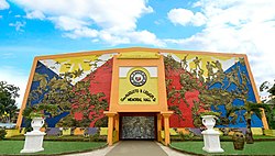
Domicile of the Santo Niño and Ati-atihan Festival known throughout the province and a week ahead of Kalibo, Makato has been celebrating the “Mother of all Philippine Festivals” in admiration of the Holy Child.
Government Officials (Elected)[]
Mayor: Abencio T. Torres
Vice Mayor: Ramon Anselmo Martin D. Legaspi III
Sangguniang Bayan Members
- Nilo Amboboyog
- Marlene Blaire Tenazas Igham
- Nerli Dela Cena
- Randy Vargas
- Rhine Ibabao Roldan
- Abencio HB Torres III
- Leoncito Mationg
- Steven Tejada
Liga ng Barangay (LnB): Bobby Clyde Legaspi
Sangguniang Kabataan Federation: Dina Mae Taladro
Infrastructure[]
The Aklan Sports Complex (Opened in 2010) was located here at Makato, where the 2010 Western Visayas Regional Athletic Association (WVRAA) Meet takes place.[25]
References[]
- ^ Municipality of Makato | (DILG)
- ^ "2015 Census of Population, Report No. 3 – Population, Land Area, and Population Density" (PDF). Philippine Statistics Authority. Quezon City, Philippines. August 2016. ISSN 0117-1453. Archived (PDF) from the original on May 25, 2021. Retrieved July 16, 2021.
- ^ a b c d Census of Population (2020). "Region VI (Western Visayas)". Total Population by Province, City, Municipality and Barangay. PSA. Retrieved 8 July 2021.
- ^ https://psa.gov.ph/sites/default/files/City%20and%20Municipal-level%20Small%20Area%20Poverty%20Estimates_%202009%2C%202012%20and%202015_0.xlsx; publication date: 10 July 2019; publisher: Philippine Statistics Authority.
- ^ "COA Report - Makato, Aklan". coa.gov.ph. Retrieved 24 May 2021.
- ^ "COA Report - Makato, Aklan". coa.gov.ph. Retrieved 24 May 2021.
- ^ "Commission on Audit Financial Report (Aklan)". Commission on Audit. Retrieved 24 May 2021.
- ^ "Commission on Audit Financial Report (Aklan)". Commission on Audit. Retrieved 24 May 2021.
- ^ "Commission on Audit Financial Report (Aklan)". Commission on Audit. Retrieved 24 May 2021.
- ^ "Commission on Audit Financial Report (Aklan)". Commission on Audit. Retrieved 24 May 2021.
- ^ "Republic Act No. 285 - An Act Creating the Municipality of Tangalan in the Province of Capiz". Chan Robles Virtual Law Library. 16 June 1948. Archived from the original on 26 September 2013. Retrieved 21 October 2016.
- ^ "Province: Aklan". PSGC Interactive. Quezon City, Philippines: Philippine Statistics Authority. Retrieved 12 November 2016.
- ^ "Makato: Average Temperatures and Rainfall". Meteoblue. Retrieved 1 May 2020.
- ^ "Municipal: Makato". PSGC Interactive. Quezon City, Philippines: Philippine Statistics Authority. Retrieved 8 January 2016.
- ^ a b Census of Population and Housing (2010). "Region VI (Western Visayas)". Total Population by Province, City, Municipality and Barangay. NSO. Retrieved 29 June 2016.
- ^ Census of Population (2015). "Region VI (Western Visayas)". Total Population by Province, City, Municipality and Barangay. PSA. Retrieved 20 June 2016.
- ^ Censuses of Population (1903–2007). "Region VI (Western Visayas)". Table 1. Population Enumerated in Various Censuses by Province/Highly Urbanized City: 1903 to 2007. NSO.
- ^ "Province of Aklan". Municipality Population Data. Local Water Utilities Administration Research Division. Retrieved 17 December 2016.
- ^ "Poverty incidence (PI):". Philippine Statistics Authority. Retrieved 28 December 2020.
- ^ https://psa.gov.ph/sites/default/files/NSCB_LocalPovertyPhilippines_0.pdf; publication date: 29 November 2005; publisher: Philippine Statistics Authority.
- ^ https://psa.gov.ph/sites/default/files/2003%20SAE%20of%20poverty%20%28Full%20Report%29_1.pdf; publication date: 23 March 2009; publisher: Philippine Statistics Authority.
- ^ https://psa.gov.ph/sites/default/files/2006%20and%202009%20City%20and%20Municipal%20Level%20Poverty%20Estimates_0_1.pdf; publication date: 3 August 2012; publisher: Philippine Statistics Authority.
- ^ https://psa.gov.ph/sites/default/files/2012%20Municipal%20and%20City%20Level%20Poverty%20Estima7tes%20Publication%20%281%29.pdf; publication date: 31 May 2016; publisher: Philippine Statistics Authority.
- ^ https://psa.gov.ph/sites/default/files/City%20and%20Municipal-level%20Small%20Area%20Poverty%20Estimates_%202009%2C%202012%20and%202015_0.xlsx; publication date: 10 July 2019; publisher: Philippine Statistics Authority.
- ^ "100315-R6-WVRAA4". Philippine Information Agency. July 9, 2018.
External links[]
Places adjacent to Makato | ||||||||||||||||
|---|---|---|---|---|---|---|---|---|---|---|---|---|---|---|---|---|
| ||||||||||||||||
Kalibo (capital) | |
| Municipalities | |
This article about a location in Western Visayas region is a stub. You can help Wikipedia by . |
- Municipalities of Aklan
- Western Visayas geography stubs